City Hall Historic District (Lowell, Massachusetts)
City Hall Historic District | |
 Lowell City Hall | |
 | |
| Location | Roughly area between Broadway and French Sts., Colburn St. and both sides of Kirk St., Lowell, Massachusetts |
|---|---|
| Coordinates | 42°38′46″N 71°18′48″W / 42.64611°N 71.31333°WCoordinates: 42°38′46″N 71°18′48″W / 42.64611°N 71.31333°W |
| Built | 1823 |
| Architect | Boot, Kirk; Multiple |
| Architectural style | Greek Revival, Romanesque Revival |
| NRHP reference No. | 75000156[1] (original) 88001906 (increase) |
| Significant dates | |
| Added to NRHP | April 21, 1975 |
| Boundary increase | October 13, 1988 |


The City Hall Historic District is a historic district in Lowell, Massachusetts roughly between Broadway and French Streets, Colburn Street and both sides of Kirk Street. The centerpiece of the district is the Richardsonian Romanesque City Hall, built in 1893 to a design by Merrill and Cutler, with its 180-foot (55 m) clock tower.[2]
The district features Greek Revival and Romanesque Revival architecture, including work by Kirk Boott. City Hall Historic District was added to the National Register of Historic Places in 1975, and expanded in 1988.[1]
Gallery[]

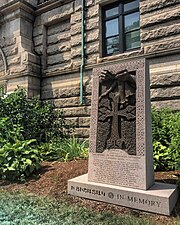
"A Mother's Hands" - Monument Dedicated to the Armenian Genocide at Lowell City Hall


See also[]
References[]
- ^ a b "National Register Information System". National Register of Historic Places. National Park Service. April 15, 2008.
- ^ "MACRIS inventory record for Lowell City Hall". Commonwealth of Massachusetts. Retrieved 2014-04-01.
| Topics |  | ||||||||||||||||
|---|---|---|---|---|---|---|---|---|---|---|---|---|---|---|---|---|---|
| Lists by county | |||||||||||||||||
| Lists by city |
| ||||||||||||||||
| Other lists | |||||||||||||||||
| |||||||||||||||||
Categories:
- Historic districts in Lowell, Massachusetts
- National Register of Historic Places in Lowell, Massachusetts
- Historic districts on the National Register of Historic Places in Massachusetts
- Middlesex County, Massachusetts Registered Historic Place stubs