City Terminal Zone
| City Terminal Zone | |||||||||||||||||||||||||||||||||||||||||||||||||||||||||||||||||||||||||||||||||||||||||||||||||||||||||||||||||||||||||||||||||
|---|---|---|---|---|---|---|---|---|---|---|---|---|---|---|---|---|---|---|---|---|---|---|---|---|---|---|---|---|---|---|---|---|---|---|---|---|---|---|---|---|---|---|---|---|---|---|---|---|---|---|---|---|---|---|---|---|---|---|---|---|---|---|---|---|---|---|---|---|---|---|---|---|---|---|---|---|---|---|---|---|---|---|---|---|---|---|---|---|---|---|---|---|---|---|---|---|---|---|---|---|---|---|---|---|---|---|---|---|---|---|---|---|---|---|---|---|---|---|---|---|---|---|---|---|---|---|---|---|---|
 Westbound view of the line at the Borden Avenue grade crossing, looking west towards Long Island City. | |||||||||||||||||||||||||||||||||||||||||||||||||||||||||||||||||||||||||||||||||||||||||||||||||||||||||||||||||||||||||||||||||
| Overview | |||||||||||||||||||||||||||||||||||||||||||||||||||||||||||||||||||||||||||||||||||||||||||||||||||||||||||||||||||||||||||||||||
| Status | Operational | ||||||||||||||||||||||||||||||||||||||||||||||||||||||||||||||||||||||||||||||||||||||||||||||||||||||||||||||||||||||||||||||||
| Owner | Long Island Rail Road | ||||||||||||||||||||||||||||||||||||||||||||||||||||||||||||||||||||||||||||||||||||||||||||||||||||||||||||||||||||||||||||||||
| Locale | Long Island, New York, USA | ||||||||||||||||||||||||||||||||||||||||||||||||||||||||||||||||||||||||||||||||||||||||||||||||||||||||||||||||||||||||||||||||
| Termini | Western termini: Atlantic Terminal Hunterspoint Avenue Long Island City Penn Station Grand Central (future) Eastern termini: Woodside (Port Washington Branch) Jamaica (all other lines) | ||||||||||||||||||||||||||||||||||||||||||||||||||||||||||||||||||||||||||||||||||||||||||||||||||||||||||||||||||||||||||||||||
| Stations | 11 (10 passenger, 1 employees-only) 2 future stations | ||||||||||||||||||||||||||||||||||||||||||||||||||||||||||||||||||||||||||||||||||||||||||||||||||||||||||||||||||||||||||||||||
| Service | |||||||||||||||||||||||||||||||||||||||||||||||||||||||||||||||||||||||||||||||||||||||||||||||||||||||||||||||||||||||||||||||||
| Type | Commuter rail | ||||||||||||||||||||||||||||||||||||||||||||||||||||||||||||||||||||||||||||||||||||||||||||||||||||||||||||||||||||||||||||||||
| System | Long Island Rail Road | ||||||||||||||||||||||||||||||||||||||||||||||||||||||||||||||||||||||||||||||||||||||||||||||||||||||||||||||||||||||||||||||||
| Services |
Belmont Park Branch
| ||||||||||||||||||||||||||||||||||||||||||||||||||||||||||||||||||||||||||||||||||||||||||||||||||||||||||||||||||||||||||||||||
| Operator(s) | Long Island Rail Road | ||||||||||||||||||||||||||||||||||||||||||||||||||||||||||||||||||||||||||||||||||||||||||||||||||||||||||||||||||||||||||||||||
| Technical | |||||||||||||||||||||||||||||||||||||||||||||||||||||||||||||||||||||||||||||||||||||||||||||||||||||||||||||||||||||||||||||||||
| Track gauge | 4 ft 8+1⁄2 in (1,435 mm) | ||||||||||||||||||||||||||||||||||||||||||||||||||||||||||||||||||||||||||||||||||||||||||||||||||||||||||||||||||||||||||||||||
| Electrification | 750 V (DC) third rail (electrified portions) | ||||||||||||||||||||||||||||||||||||||||||||||||||||||||||||||||||||||||||||||||||||||||||||||||||||||||||||||||||||||||||||||||
| |||||||||||||||||||||||||||||||||||||||||||||||||||||||||||||||||||||||||||||||||||||||||||||||||||||||||||||||||||||||||||||||||
The City Terminal Zone, also known as the City Zone Branch,[1] is a collection of rail lines of the Long Island Rail Road in New York City. Specifically, it includes to all stations that lie in fare zone 1 (except for Mets–Willets Point on the Port Washington Branch), which is the set of stations west of Jamaica.
Routes[]
Current routes[]
There are three routes that are part of the City Terminal Zone:[2]
- New York Penn Station (NYP) – Trains that, from Jamaica, travel west along the Main Line to Penn Station in Manhattan via the East River Tunnels.
- Atlantic Terminal (AT) – Trains that travel along the Atlantic Branch to Brooklyn.
- Long Island City (LIC) – Trains that serve Hunterspoint Avenue and Long Island City in Queens. These trains also use the Main Line west of Jamaica, but typically skip Woodside, Forest Hills, and Kew Gardens. This route is served only during weekday rush hours in the peak direction (to Long Island City in the morning, from Long Island City in the afternoon).
Future routes[]
The City Terminal Zone is slated to include a branch to a new station underneath Grand Central Terminal as part of the East Side Access project, which is anticipated to open in late 2022.[3] A new station in Sunnyside, Queens, is scheduled to be built once the remainder of the project is complete.
To access the new terminal, trains will cross the East River via the lower level of the 63rd Street Tunnel, and then through a new tunnel under Park Avenue.[4] However, due to clearance restrictions in the tunnel, the C3 bilevel cars will be unable to access the new terminal, thus requiring passengers traveling to/from stations in diesel territory to transfer further east (ie: at Jamaica) to an electric train.[4]
Former routes[]
The City Terminal Zone formerly included the Lower Montauk Branch from Long Island City to Jamaica until passenger service on that route was discontinued in November 2012. This line formerly included Penny Bridge, Haberman, Fresh Pond, Glendale, and Richmond Hill stations until they were closed in March 1998.[5]
Stations[]
East of Jamaica, trains continue in Long Island on the Main Line (Hempstead, Oyster Bay, Port Jefferson, Ronkonkoma), Atlantic Branch (Far Rockaway and Long Beach), and Montauk Branch (West Hempstead, Babylon, Montauk).
| Zone | Routes | Location | Station | Connections and notes | ||
|---|---|---|---|---|---|---|
| NYP | AT | LIC | ||||
| 1 | ● | Manhattan | Pennsylvania Station |
Amtrak (long distance): Cardinal, Crescent, Lake Shore Limited, Palmetto, Silver Meteor, Silver Star Amtrak (intercity): Acela Express, Adirondack, Carolinian, Empire Service, Ethan Allen Express, Keystone Service, Maple Leaf, Northeast Regional, Pennsylvanian, Vermonter NJ Transit Rail: Gladstone, Montclair-Boonton, Morristown, Northeast Corridor, North Jersey Coast, Raritan Valley lines New York City Subway: 1, 2, and 3 (at 34th Street–Penn Station), A, C, and E (at 34th Street–Penn Station New York City Bus: M4, M7, M20, M34 SBS, M34A SBS, Q32 | ||
| ● | Long Island City, Queens | Long Island City |
New York City Subway: 7 and <7> (at Vernon Boulevard-Jackson Avenue) MTA Bus: Q103 NYC Ferry: East River | |||
| ● | Hunterspoint Avenue | New York City Subway: 7 and <7> (at Hunters Point Avenue), G (at 21st Street) New York City Bus: B62 MTA Bus: Q67 | ||||
| ● | Woodside, Queens | Woodside |
Long Island Rail Road: Port Washington Branch New York City Subway: 7 and <7> at (61st Street–Woodside) New York City Bus: Q32 MTA Bus: Q18, Q53 SBS, Q70 SBS | |||
| ● | Forest Hills, Queens | Forest Hills |
New York City Subway: E, F, <F>, M, and R (at Forest Hills–71st Avenue) MTA Bus: Q32, Q60, Q64 | |||
| ● | Kew Gardens, Queens | Kew Gardens | New York City Bus: Q10, Q37 MTA Bus: QM18 | |||
| ● | Brooklyn | Atlantic Terminal |
New York City Subway: 2, 3, 4, 5, B, D, N, Q, R and W (at Atlantic Avenue–Barclays Center New York City Bus: B41, B45, B63, B65, B67 | |||
| ● | Nostrand Avenue |
New York City Subway: A and C (at Nostrand Avenue) New York City Bus: B52, B44 SBS, B65 | ||||
| ● | East New York | New York City Subway: L at (Atlantic Avenue), A, C, J, L, and Z (at Broadway Junction) New York City Bus: B12, B20, B25, B83, Q24, Q56 | ||||
| ● | Richmond Hill, Queens | Boland's Landing | Employees only | |||
| 3 | ● | ● | ● | Jamaica, Queens | Jamaica |
Long Island Rail Road: Babylon, Far Rockaway, Hempstead, Long Beach, Montauk, Oyster Bay, Port Jefferson, Ronkonkoma, West Hempstead branches New York City Subway: E, J, and Z (at Sutphin Boulevard–Archer Avenue–JFK Airport) New York City Bus: Q20A, Q20B, Q24, Q30, Q31, Q43, Q44 SBS, Q54, Q56 MTA Bus: Q6, Q8, Q9, Q25, Q34, Q40, Q41, Q60, Q65 Nassau Inter-County Express: n4 AirTrain JFK: Jamaica Station Route |
See also[]
References[]
- ^ "Long island City". Metropolitan Transit Authority. Retrieved January 21, 2017.
- ^ "City Terminal Zone Timetable" (PDF). Metropolitan Transportation Authority. February 16, 2018. Retrieved August 16, 2020.
- ^ "East Side Access". A Modern LI. Retrieved August 16, 2020.
- ^ a b "Chapter 28: Comments and Responses on the Draft Environmental Impact Statement". East Side Access Environmental Impact Statement (PDF). mta.info. MTA Capital Construction. March 2001. Retrieved February 2, 2018.
- ^ "End of the Line for L.I.R.R.'s 10 Loneliest Stops". Retrieved August 16, 2020.
External links[]
Route map:

| ( • help)
|
| Main routes | 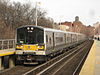  | ||||
|---|---|---|---|---|---|
| Branch services | |||||
| Freight operations |
| ||||
| Defunct branches | |||||
| Acquired railroads |
| ||||
| Other | |||||
- Long Island Rail Road branches
- Transportation in Manhattan
- Transportation in Brooklyn
- Transportation in Queens, New York