Clares
Clares, Spain | |
|---|---|
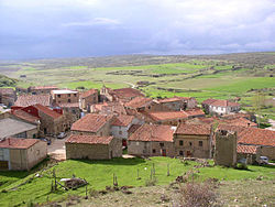 View of Clares in 2007 | |
| Coordinates: 41°02′06″N 2°08′34″W / 41.0351°N 2.1427°WCoordinates: 41°02′06″N 2°08′34″W / 41.0351°N 2.1427°W | |
| Country | Spain |
| Autonomous community | Castile-La Mancha |
| Province | Guadalajara |
| Municipality | Maranchón |
| Area | |
| • Total | 17.2 km2 (6.6 sq mi) |
| Elevation | 1,281 m (4,203 ft) |
| Population (2016) | |
| • Total | 9 |
| • Density | 0.52/km2 (1.4/sq mi) |
| Time zone | UTC+1 (CET) |
| • Summer (DST) | UTC+2 (CEST) |
| Website | soydeclares |

Clares is a small village in the Guadalajara province, incorporated since 1969 in the Maranchón municipality, belonging to the Señorio de Molina-Alto Tajo region in the autonomous community of Castilla - La Mancha (Spain).
Geography[]
Location[]
Clares is in the north of the Guadalajara province, 108 km from the provincial capital.
Demography[]
The population, as of 1 January 2008, was 20.
Climatology[]
The annual average temperature is 8-10 °C, and the average temperature of the hottest month in the summer is less than 25 °C. The total annual amount of precipitation is about 500 mm, with two peaks in spring and autumn.
Orography[]
Clares´ highest point is the Alto del Monte (1362m), and its lowest point is in Valdeclares (1280m). The origin of the Tajuña River is near the village.
Flora[]
Clares belongs to the .
Traditional Celebrations[]
- Burning of "el Judas"
- Virgen del Lluvio (Virgin of the Rain)
- San Roque
- Virgen del Rosario (Virgin of the Rosary)
- El Ojeo (the beating)
Interesting buildings[]
- Local Church
- Ermita de San Roque
- Ermita de la Virgen del Lluvio
- Bread oven
How to get to Clares[]

By Car[]
Take exit 135 on road A-2, then enter N211 and continue there 21 km until you reach Maranchón. Then you take road GU-408 to Clares / Codes / Balbacil / . Then, 700m later, take GU-407 to Clares / Balbacil. Finally, take the entrance to Clares.
By bus[]
The line Madrid / Guadalajara / Teruel / Valencia has a stop in Maranchón, 6 km from Clares.
By train[]
The nearest train stations are in Medinaceli (32 km, roads: SO-411, GU-411, N-211, GU-408 y GU-407) and in Arcos de Jalón (30 km, roads: SO-P-3009, GU-405, N-211, GU-408 y GU-407), both of them are on the Madrid - Zaragoza line.
References[]
- PÉREZ TABERNERO and BARBA MAYORAL. Historia y tradiciones de Clares Asociación de Vecinos y Amigos de Clares y Ayuntamiento de Maranchón. Maranchón, 1999.
External links[]
- Towns in Spain