Clatsop State Forest
| Clatsop State Forest | |
|---|---|
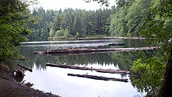 Lost Lake in the Clatsop State Forest (Astoria District), July 2012 | |
 | |
| Type | State forest |
| Location | Oregon, United States |
| Coordinates | 45°56′13″N 123°13′09″W / 45.93694°N 123.21917°WCoordinates: 45°56′13″N 123°13′09″W / 45.93694°N 123.21917°W[1] |
| Area | 136,000 acres (550 km2)[2] |
| Operated by | Oregon Department of Forestry |

Clatsop State Forest is a state forest in Clatsop and Columbia counties in the U.S. state of Oregon. It is managed by the Astoria District of the Oregon Department of Forestry.[2]
References[]
- ^ "Clatsop State Forest". Geographic Names Information System. United States Geological Survey.
- ^ Jump up to: a b "Astoria District". Oregon Department of Forestry.
External links[]
| show Protected areas of Oregon |
|---|
| show Authority control |
|---|
This Clatsop County, Oregon state location article is a stub. You can help Wikipedia by . |
This Columbia County, Oregon state location article is a stub. You can help Wikipedia by . |
Categories:
- Oregon state forests
- Protected areas of Clatsop County, Oregon
- Protected areas of Columbia County, Oregon
- Oregon geography stubs
- Portland metropolitan area geography stubs