Clayton-Marsh Creek-Greenville Fault
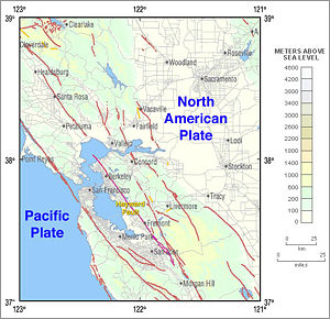
The Clayton-Marsh Creek-Greenville Fault is a fault located in the eastern San Francisco Bay Area of California, in Alameda County and Contra Costa County. It is part of the somewhat parallel system of faults that are secondary to the San Andreas Fault.
Seismic activity[]
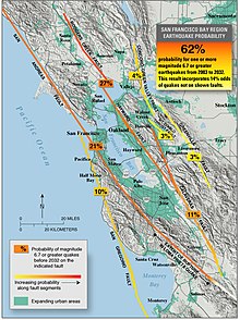
The 5.8 magnitude 1980 Livermore earthquake occurred on this fault.[1] The fault creeps at a rate of at 2 mm/year.[2] The predicted probability of a major earthquake on this fault within the next 30 years is relatively low, at 3%, compared to nearby faults such as the Hayward Fault.
See also[]
References[]
- ^ Tinsley, M.G. "Surface Faulting near Livermore, California Associated with the January 1980 Earthquakes". pubs.usgs.gov. Retrieved 2015-05-18.
- ^ Lienkaemper, James J.; Barry, G. Robert; Smith, Forrest E.; Mello, Joseph D.; McFarland, Forrest S. (2013). "The Greenville Fault: Preliminary Estimates of Its Long‐Term Creep Rate and Seismic Potential" (PDF). Bulletin of the Seismological Society of America. 103 (5): 2729–2738. Bibcode:2013BuSSA.103.2729L. doi:10.1785/0120120169. ISSN 0037-1106.
Coordinates: 37°42′N 121°40′W / 37.7°N 121.67°W

This Contra Costa County, California–related article is a stub. You can help Wikipedia by . |
This Alameda County, California–related article is a stub. You can help Wikipedia by . |
This tectonics article is a stub. You can help Wikipedia by . |
- Seismic faults of California
- Geography of Alameda County, California
- Natural history of Contra Costa County, California
- Contra Costa County, California geography stubs
- Alameda County, California geography stubs
- Tectonics stubs