Cliffs of Magho

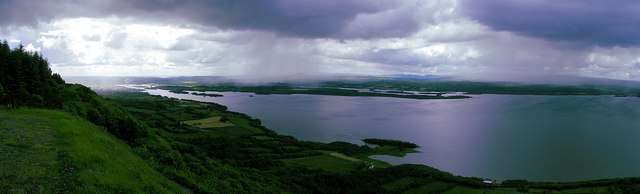
The Cliffs of Magho are a 9-kilometre-long (5.6 mi) limestone escarpment located in the townland of Magho, County Fermanagh, Northern Ireland. The NNW-facing cliffs overlook the western reaches of Lower Lough Erne and define the northern edge of , a major plantation managed by the . A popular viewpoint atop the cliffs is accessed by a forest drive.
The escarpment is formed from two distinct bands of Carboniferous limestone: the Glencar Limestone Formation and the overlying Dartry Limestone Formation. These overlie a series of mudrocks known as the Benbulben Shale Formation. Under the cliffs lie a mostly continuous apron of scree and landslipped material.
The cliffs are a proposed Area of Special Scientific Interest. They are home to the Irish Rock-bristle (), a black moss found on wet calcareous rocks and known only from this site in the whole of the United Kingdom, though found elsewhere in the Republic of Ireland.[1]
On the 18 November 1943 an Royal Air Force, Short Sunderland (W4036) flying boat of No. 201 Squadron RAF was operating a training flight, practicing takeoffs and landings on Lough Erne. During one take off the aircraft overshot flare path, shortly after the left wing struck the lough. The pilots lost control of the aircraft & crashed into Cliffs of Magho, busting into flames on impact. Three of the Eight crew onboard died in the crash.[2]
Since 2007 these cliffs have formed a part of the Marble Arch Caves Global Geopark.[3]
References[]
- ^ "Magho Cliffs – Summary". Earth Science Conservation Review. National Museums Northern Ireland. Retrieved 4 September 2012.
- ^ "ASN Aircraft accident Short Sunderland III W4036 Lough Erne".
- ^ "Geopark News: The Worlds First International Geopark!". Fermanagh District Council. 2008. Archived from the original on 15 June 2011. Retrieved 4 September 2012.
Coordinates: 54°28′01″N 7°54′23″W / 54.4670°N 7.9065°W

This article related to the geography of County Fermanagh, Northern Ireland is a stub. You can help Wikipedia by . |
- Landforms of County Fermanagh
- Escarpments of the United Kingdom
- Aviation accidents and incidents locations in Northern Ireland
- County Fermanagh geography stubs