Clitunno
This article needs additional citations for verification. (May 2020) |
| Clitunno | |
|---|---|
 Source of the Clitunno near Campello sul Clitunno | |
| Location | |
| Country | Umbria, Italy |
| Physical characteristics | |
| Mouth | |
• location | Bevagna |
• coordinates | 42°55′58″N 12°36′15″E / 42.9329°N 12.6042°ECoordinates: 42°55′58″N 12°36′15″E / 42.9329°N 12.6042°E |
| Basin features | |
| Progression | → Topino→ Chiascio→ Tiber→ Tyrrhenian Sea |


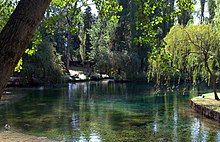
The Clitunno, in Antiquity the Clitumnus, is a river in Umbria, Italy. The name is of uncertain origin, but it was also borne by the river god. The Clitunno rises at 42°49.5′N 12°46′E / 42.8250°N 12.767°E from a spring within a dozen metres of the ancient Via Flaminia near the town of Campello sul Clitunno between Spoleto and Trevi: the spring was celebrated as a great beauty spot by the Romans but also by Byron and Giosuè Carducci; in the 19th century it was planted with willows, and zealously monitored for pollution, it is open today as a paying tourist attraction.
The Clitunno then flows, generally north, through the east Umbrian plain, past the Temple of Clitumnus and the towns of , Cannaiola and Trevi, to join the , a tributary of the Topino, near Bevagna.[1] Though its current is usually sluggish, it is subject, like many other rivers in the east Umbrian plain, to sudden flooding: it was only tamed completely in the 19th century, and is largely banked by levees.
References[]
- ^ Agenzia regionale di protezione ambientale dell'Umbria, Caratterizzazione dei bacini idrografici e dei corpi idrici superficiali, Sottobacino Topino Marroggia, map p. 10 of 22.
External links[]
![]() Media related to Clitunno River at Wikimedia Commons
Media related to Clitunno River at Wikimedia Commons
| hide Authority control | |
|---|---|
| General | |
| National libraries | |
| Other | |
- Tributaries of the Tiber
- Rivers of the Province of Perugia
- Rivers of Italy