Cloud Peak Wilderness
| Cloud Peak Wilderness | |
|---|---|
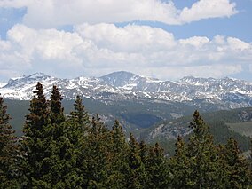 Cloud Peak Wilderness, as viewed from Freezout, off Cold Springs Road. | |
 | |
| Location | Johnson / Big Horn / Sheridan counties, Wyoming, USA |
| Nearest city | Sheridan, WY |
| Coordinates | 44°23′55″N 107°12′07″W / 44.39861°N 107.20194°WCoordinates: 44°23′55″N 107°12′07″W / 44.39861°N 107.20194°W |
| Area | 189,039 acres (765.01 km2) |
| Established | 1984 |
| Governing body | U.S. Forest Service |

The Cloud Peak Wilderness is located in north central Wyoming in the United States. Entirely within Bighorn National Forest,[1] the wilderness was established in 1984 in an effort to preserve the wildest section of the Bighorn Mountains. The wilderness has the highest peaks in the Bighorn Mountains including Cloud Peak and Black Tooth Mountain, as well as Cloud Peak Glacier, the only remaining active glacier in the Bighorn Mountains. The Cloud Peak Wilderness is 189,039 acres (765.01 km2).
U.S. Wilderness Areas do not allow motorized or mechanized vehicles, including bicycles. Although camping and fishing are allowed with proper permit, no roads or buildings are constructed and there is also no logging or mining, in compliance with the 1964 Wilderness Act. Wilderness areas within National Forests and Bureau of Land Management areas also allow hunting in season.
Climate[]
| hideClimate data for Cloud Peak Wilderness | |||||||||||||
|---|---|---|---|---|---|---|---|---|---|---|---|---|---|
| Month | Jan | Feb | Mar | Apr | May | Jun | Jul | Aug | Sep | Oct | Nov | Dec | Year |
| Average high °F (°C) | 35.6 (2.0) |
40.4 (4.7) |
49.7 (9.8) |
59.2 (15.1) |
69.2 (20.7) |
79.0 (26.1) |
86.7 (30.4) |
85.6 (29.8) |
75.1 (23.9) |
62.3 (16.8) |
45.2 (7.3) |
37.4 (3.0) |
60.5 (15.8) |
| Daily mean °F (°C) | 24.7 (−4.1) |
29.4 (−1.4) |
38.1 (3.4) |
46.7 (8.2) |
56.1 (13.4) |
65.5 (18.6) |
72.6 (22.6) |
71.7 (22.1) |
61.6 (16.4) |
50.0 (10.0) |
35.4 (1.9) |
26.9 (−2.8) |
48.2 (9.0) |
| Average low °F (°C) | 13.7 (−10.2) |
18.4 (−7.6) |
26.5 (−3.1) |
34.2 (1.2) |
43.0 (6.1) |
51.9 (11.1) |
58.4 (14.7) |
57.9 (14.4) |
48.0 (8.9) |
37.6 (3.1) |
25.5 (−3.6) |
16.4 (−8.7) |
36.0 (2.2) |
| Average precipitation inches (mm) | 0.5 (13) |
0.3 (7.6) |
0.9 (23) |
1.3 (33) |
2.3 (58) |
1.8 (46) |
0.9 (23) |
0.6 (15) |
1.4 (36) |
1.2 (30) |
0.7 (18) |
0.6 (15) |
12.5 (317.6) |
| Source: climbingweather.com [2] | |||||||||||||
See also[]
- List of U.S. Wilderness Areas
References[]
- ^ "Cloud Peak Wilderness". Retrieved 2019-10-06.
- ^ "climbingweather.com". Retrieved October 6, 2019.
External links[]
- "Cloud Peak Wilderness". The National Wilderness Preservation System. Wilderness.net. Retrieved 2006-08-16.
- "USGS Cloud Peak (WY) Topo Map Quad". TopoQuest. Retrieved 2008-06-30.
- "Wilderness Legislation: The Wilderness Act of 1964". The National Wilderness Preservation System. Wilderness.net. Retrieved 2006-08-16.
| show Authority control |
|---|
This article related to a protected area in Wyoming is a stub. You can help Wikipedia by . |
- IUCN Category Ib
- Protected areas of Big Horn County, Wyoming
- Protected areas of Johnson County, Wyoming
- Protected areas of Sheridan County, Wyoming
- Wilderness Areas of Wyoming
- Bighorn National Forest
- Protected areas established in 1984
- 1984 establishments in Wyoming
- Wyoming geography stubs
- Western United States protected area stubs