Cobija
Cobija | |
|---|---|
Capital city of the Pando Department, Bolivia. | |
 | |
 Cobija Location in Bolivia | |
| Coordinates: 11°01′50″S 68°46′00″W / 11.03056°S 68.76667°W | |
| Country | |
| Department | |
| Province | Nicolás Suárez |
| Founded | 1906 |
| Government | |
| • Mayor | Ana Lucia Reis Melena |
| Area | |
| • Total | 401 km2 (155 sq mi) |
| Elevation | 280 m (919 ft) |
| Population (2020) | |
| • Total | 78,555 |
| • Density | 200/km2 (510/sq mi) |
| Time zone | UTC-4 (BOT) |
| Area code(s) | +591 842 |


The capital of the Bolivian department of Pando, Cobija, is located about 600 km (373 mi.) north of La Paz in the Amazon Basin on the border with Brazil. Cobija lies on the banks of the Rio Acre across from the Brazilian city of Brasiléia. Cobija lies at an elevation of ca. 280 m (920 ft.) above sea level and has a tropical and rainy climate.
Cobija has approximately 80,000 inhabitants, is the seat of a university and capital of the Bolivian Pando Department. Cobija has two airports and is connected by one road to El Choro in the Beni Department, which is not always passable during the rainy season. When the rain allows it, Cobija is connected to the rest of Bolivia also via road. Cobija is connected to Brazil by two bridges.[1]
History[]
Cobija was founded in 1906 by Colonel Enrique Cornejo, originally under the name of Bahía and received its current name in 1908 in commemoration of the former Bolivian seaport Cobija on the Pacific, which has been a part of Chile since the War of the Pacific. In the early 1900s, Cobija experienced a boom as an India rubber industry center. When the industry collapsed, a major source of income being lost, Cobija became impoverished and its population fell. Nowadays, Cobija is developing again and its population is increasing. Currently, the region's primary industry is Bolivia nuts, although tourism and commerce are growing. There is a Free economic zone in the city, the largest in Bolivia.[2]
Population[]
The inhabitants of Cobija has risen very strongly during the past two decades to more than five-fold. Currently the estimated population is as much as 80,000 inhabitants with a population growth of 6 to 8% per year.
| Year | Population | Census |
|---|---|---|
| 1992 | 10 001 | census[3] |
| 2001 | 20 820 | census[4] |
| 2020 | 78,555 | census[5] |
Sports[]
The Estadio Roberto Jordán Cuellar is located in Cobija. The football stadium has a capacity of 24,000.
Climate[]
The city of Cobija sits on a sharp curve of the Acre river. Located at an altitude of 280 metres (920 ft) above sea level and in the north-western jungle region – in Brazilian border – Cobija is considered the rainiest region in Bolivia. It is also a warm spot (exception made for a couple of weeks a year, when a fresh wind from the south blows), with day temperatures above 26 °C (79 °F) most of the time. Cobija has two seasons: The rain season (when is possible to enjoy powerful rainfalls and the vegetation is at its best) and the dry season (when roads are good and excursions deep into the Jungle are made possible, to "lago Bay" for instance). Usually locals use the hottest hours of the day to stay at home, have lunch and a good siesta. But the most active ones enjoy also outdoor activities. The average annual precipitation averages between 1,500 to 2,000 millimetres (59 to 79 in) depending upon the seasonal flooding intensity. Furthermore, contrary to popular belief, Cobija is not the wettest area in Bolivia, as the average annual precipitation in the Chapare lowlands of Cochabamba can receive more than 5,500 millimetres (220 in) of rain per year in some areas.
| hideClimate data for Cobija | |||||||||||||
|---|---|---|---|---|---|---|---|---|---|---|---|---|---|
| Month | Jan | Feb | Mar | Apr | May | Jun | Jul | Aug | Sep | Oct | Nov | Dec | Year |
| Record high °C (°F) | 35.4 (95.7) |
35.0 (95.0) |
35.0 (95.0) |
35.4 (95.7) |
35.0 (95.0) |
37.2 (99.0) |
35.2 (95.4) |
37.6 (99.7) |
38.6 (101.5) |
38.2 (100.8) |
35.0 (95.0) |
35.9 (96.6) |
38.6 (101.5) |
| Average high °C (°F) | 31.2 (88.2) |
30.8 (87.4) |
31.8 (89.2) |
31.2 (88.2) |
29.2 (84.6) |
29.9 (85.8) |
30.2 (86.4) |
33.4 (92.1) |
34.5 (94.1) |
31.9 (89.4) |
31.4 (88.5) |
31.2 (88.2) |
31.4 (88.5) |
| Daily mean °C (°F) | 26.1 (79.0) |
26.0 (78.8) |
26.2 (79.2) |
25.6 (78.1) |
25.2 (77.4) |
24.1 (75.4) |
24.6 (76.3) |
25.5 (77.9) |
26.6 (79.9) |
26.8 (80.2) |
26.6 (79.9) |
26.4 (79.5) |
25.8 (78.4) |
| Average low °C (°F) | 21.3 (70.3) |
21.5 (70.7) |
21.1 (70.0) |
20.8 (69.4) |
18.9 (66.0) |
16.8 (62.2) |
15.8 (60.4) |
17.7 (63.9) |
19.8 (67.6) |
20.5 (68.9) |
20.9 (69.6) |
21.0 (69.8) |
19.7 (67.5) |
| Record low °C (°F) | 16.0 (60.8) |
18.2 (64.8) |
16.0 (60.8) |
11.4 (52.5) |
8.0 (46.4) |
9.5 (49.1) |
9.0 (48.2) |
11.4 (52.5) |
10.0 (50.0) |
14.6 (58.3) |
17.0 (62.6) |
16.0 (60.8) |
8.0 (46.4) |
| Average precipitation mm (inches) | 196 (7.7) |
205 (8.1) |
180 (7.1) |
157 (6.2) |
61 (2.4) |
25 (1.0) |
18 (0.7) |
30 (1.2) |
68 (2.7) |
130 (5.1) |
185 (7.3) |
191 (7.5) |
1,446 (56.9) |
| Average precipitation days (≥ 0.1 mm) | 17 | 13 | 13 | 11 | 6 | 3 | 2 | 3 | 6 | 9 | 11 | 11 | 105 |
| Average relative humidity (%) | 84 | 85 | 83 | 83 | 82 | 81 | 76 | 74 | 73 | 78 | 81 | 83 | 80 |
| Source: Deutscher Wetterdienst[6] | |||||||||||||
Gallery[]
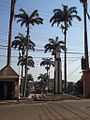
Cobija, Bolivia

Central Park in Cobija

View along the road towards Riberalta
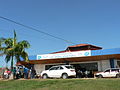
Old facade of Cobija airport, before the reformation.
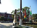
Simón Bolívar bust in Cobija

Cobija, Pando, Bolivia
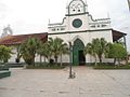
Nuestra Señora del Pilar Cathedral in Cobija and the city main square
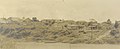
Cobija, 1930.


Transportation[]
Cobija is served by major Bolivian airlines at Captain Aníbal Arab Airport[7] and by buses to Riberalta. The Interoceanic Highway passes through the city of Cobija.
Coordinates: 11°02′S 68°44′W / 11.033°S 68.733°W
References[]
- ^ "Bolivia: Municipal Division (Departments and Municipalities) - Population Statistics, Charts and Map".
- ^ http://zofracobija.gob.bo/
- ^ INE – Instituto Nacional de Estadística Bolivia 1992 Archived 2014-04-23 at the Wayback Machine
- ^ INE – Instituto Nacional de Estadística Bolivia 2001 Archived 2016-03-03 at the Wayback Machine
- ^ "Bolivia: Municipal Division (Departments and Municipalities) - Population Statistics, Charts and Map".
- ^ "Klimatafel von Cobija, Prov. Pando / Bolivien" (PDF). Baseline climate means (1961-1990) from stations all over the world (in German). Deutscher Wetterdienst. Archived from the original (PDF) on 24 February 2020. Retrieved 27 January 2016.
- ^ http://www.visitbolivia.org/pando-en.php
| show Authority control |
|---|
- Populated places in Pando Department
- Populated places established in 1906
- Bolivia–Brazil border crossings
- 1906 establishments in Bolivia