Codfish Island / Whenua Hou
Whenua Hou (Māori) | |
|---|---|
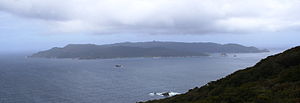 Codfish Island / Whenua Hou as viewed from neighbouring Rakiura | |
 Map of Stewart Island / Rakiura, with Codfish Island / Whenua Hou to the northwest. | |
| Geography | |
| Location | Tasman Sea |
| Coordinates | 46°47′S 167°38′E / 46.783°S 167.633°E |
| Archipelago | New Zealand archipelago |
| Total islands | 1 |
| Area | 14 km2 (5.4 sq mi) |
| Highest elevation | 250 m (820 ft)[1] |
| Administration | |
| Region | Southland Region |
| Demographics | |
| Population | (?) |

Codfish Island / Whenua Hou is a small island (14 km2 or 5.4 sq mi) located to the west of Stewart Island / Rakiura in southern New Zealand. It reaches a height of 250 m (820 ft) close to the south coast. The island is home to Sirocco, an internationally famous kākāpō, a rare species of parrot.
History and Name[]
The island is one of many geographic features in New Zealand to have a dual place name, consisting of the former English and Māori names separated by a slash. The former English name "Codfish Island" refers to the endemic blue cod or rāwaru / pākirikiri, which is fished commercially in surrounding waters by trapping in baited pots. The Māori name "Whenua Hou" means "new land", which dates back to the early days of Pākehā settlement in New Zealand.[2] Responding to concerns and allegations that local Māori women were being harassed by sealers on nearby Rakiura, the local Ngāi Tahu rangatira, Honekai, designated Whenua Hou as the site of a new mixed race settlement where early Pākehā could live with their Māori wives under his protection.[3] This encouraged sealers to move to Whenua Hou, alleviating the issues which their presence had caused on nearby Rakiura and making Whenua Hou one of the first permanent mixed Māori and European settlements in the region.[4]
Wildlife[]
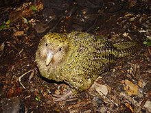
Following the eradication of possums and rats in 1998 and the transfer of weka to other islands, Codfish is a predator-free bird sanctuary and the focus of kākāpō recovery efforts. It holds the majority of the breeding population of critically endangered kākāpō. In 2002, 24 kākāpō chicks fledged on the island. In 2009 and 2016, 33 and 32 chicks fledged respectively.[5] Its most famous resident is Sirocco, a kākāpō born in 1997; Sirocco became the government's "Official Spokesbird for Conservation" in 2010.[6]
Codfish Island is also home to southern short-tailed bats, kākā, fernbirds, red-fronted and yellow-crowned parakeet (both referred to as kākāriki), Pacific black ducks and a recently introduced population of mōhua.
The island has been identified as an Important Bird Area by BirdLife International because of its significance as a breeding site for several species of seabirds, including Fiordland and yellow-eyed penguins, and mottled, Cook's and Whenua Hou diving petrels.[7]
Access[]
The island is visited by scientific researchers and Department of Conservation field workers along with volunteers working on conservation programs. The sole hut is located at in the northeast, with access by light aircraft or helicopter. The island is closed to casual visitors and unauthorised landing is prohibited.
See also[]
References[]
- ^ "Codfish Island (Whenuahou), Southland - NZ Topo Map". Land Information New Zealand. Retrieved 2017-10-17.
- ^ Te Kohanga Ote Whenua Hou, pers comm
- ^ "NZGB Gazetteer: Codfish Island / Whenua Hou". gazetteer.linz.govt.nz. Retrieved 14 August 2021.
- ^ "Kā Huru Manu: Whenua Hou". Kā Huru Manu: The Ngāi Tahu Atlas. Ngāi Tahu. Retrieved 14 August 2021.
- ^ "Whenua Hou - Codfish Island - Kākāpō Recovery". Kākāpō Recovery. Retrieved 2017-11-16.
- ^ Milne, Amy (15 January 2010). "Sirocco chills out on Codfish Island". The Southland Times. Retrieved 15 June 2015.
- ^ BirdLife International. (2012). Important Bird Areas factsheet: Codfish Island. Downloaded from "Archived copy". Archived from the original on 2007-07-10. Retrieved 2012-12-14.CS1 maint: archived copy as title (link) on 31 January 2012.
External links[]
| Wikimedia Commons has media related to Codfish Island. |
- Minders: The Kakapo caregivers of Codfish Island New Zealand Geographic
| hide Authority control | |
|---|---|
| General |
|
| National libraries | |
- Islands of Southland, New Zealand
- Stewart Island
- Island restoration
- Important Bird Areas of New Zealand