Coeur d'Alene National Forest
| Coeur d'Alene National Forest | |
|---|---|
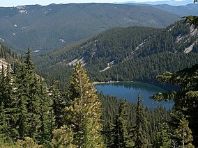 Revett Lake in Coeur d'Alene National Forest | |
 | |
| Location | Idaho, United States |
| Nearest city | Coeur d'Alene, ID |
| Coordinates | 47°48′N 116°18′W / 47.8°N 116.3°WCoordinates: 47°48′N 116°18′W / 47.8°N 116.3°W |
| Area | 726,362 acres (2,939.48 km2) |
| Established | November 6, 1906 |
| Governing body | U.S. Forest Service |
| Website | Idaho Panhandle National Forests |

The Coeur d'Alene is a U.S. National Forest located in the Idaho panhandle and is one of three forests that are aggregated into the Idaho Panhandle National Forests (the other two are the Kaniksu and St. Joe National Forests). Coeur d'Alene National Forest is located in Shoshone, Kootenai, and Bonner counties in northern Idaho. It has a total area of 726,362 acres (1,135 sq mi or 2,940 km²).[1]
The forest headquarters is located in Coeur d'Alene, Idaho. There are local ranger district offices located in Coeur d'Alene and Silverton.
References[]
- ^ Table 6 - NFS Acreage by State, Congressional District and County - United States Forest Service - September 30, 2007
External links[]
 Media related to Idaho Panhandle National Forests (category) at Wikimedia Commons
- Coeur d'Alene River Ranger District - Idaho Panhandle National Forests
| show Authority control |
|---|
This article related to a protected area in Idaho is a stub. You can help Wikipedia by . |
This Bonner County, Idaho state location article is a stub. You can help Wikipedia by . |
This Kootenai County, Idaho state location article is a stub. You can help Wikipedia by . |
This Shoshone County, Idaho state location article is a stub. You can help Wikipedia by . |
- Protected areas of Bonner County, Idaho
- Protected areas of Kootenai County, Idaho
- National Forests of Idaho
- Protected areas of Shoshone County, Idaho
- Idaho Panhandle National Forest
- Protected areas established in 1906
- 1906 establishments in Idaho
- Coeur d'Alene, Idaho
- Idaho geography stubs
- Western United States protected area stubs