Col des Champs
| Col des Champs | |
|---|---|
 Col des Champs, in the background the Tête de l'Encombrette | |
| Elevation | 2,087 m (6,847 ft) |
| Traversed by | D2 |
| Location | France |
| Range | Alps |
| Coordinates | 44°10′41″N 06°42′5″E / 44.17806°N 6.70139°ECoordinates: 44°10′41″N 06°42′5″E / 44.17806°N 6.70139°E |
 Col des Champs Location of Col des Champs | |

Col des Champs (elevation 2,087 m (6,847 ft)) is a high mountain pass in the Alps at the border between the departments of Alpes-de-Haute-Provence and Alpes-Maritimes in France. It connects Saint-Martin-d'Entraunes and Colmars, joining the valleys of the Var River and the Verdon River.
Together with the Col de la Cayolle and the Col d'Allos it forms part of a popular round trip for cyclists (see for example [1]).
Details of the climb[]
The western side, from Colmars, is 12.5 km long, climbing 827 m (2,713 ft) at an average of 6.6%.[2] The state of the pavement is partly very poor (as of August 2014). While some parts are recently renovated, others contain numerous potholes and are covered by loose gravel. On this side mountain pass cycling milestones for cyclists are placed approximately every kilometre. They indicate the current height, the distance to the summit, the average slope in the following passage, as well as the number of the street (D2).
Starting from Saint-Martin-d'Entraunes, the climb is 16.5 km gaining 1,055 m (3,461 ft), resulting in an average of 6.4%.[3] The state of the pavement is generally good on this side. No signposts for cyclists are placed on this side. However, every kilometre a sign indicates the altitude, as well as the distance to the summit (uphill) or the next villages (uphill and downhill).
The exact height[]
The height of the summit is commonly specified by 2,087 m (6,847 ft), including the signpost at the summit used until 2013. However, the current signpost at the summit indicates a height of 2,080 m (6,820 ft) (see below). A topographic map [4] of the French Institut géographique national marks 2,088 m (6,850 ft) at this position of the sign, and 2,089 m (6,854 ft) some 50 metres away from the signpost.
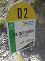
One of the mountain pass cycling milestones along the climb from Colmars
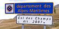
Signpost at the summit of the Col des Champs as of 2013

Signpost at the summit of the Col des Champs as of 2014


References[]
- ^ "Cayolle-Champs-Allos - Bikemap - Your bike routes online". bikemap.net. Retrieved 22 August 2014.
- ^ "Col des Champs (2087 m)" (in German). www.quaeldich.de. Retrieved 22 August 2014.
- ^ "Col des Champs (2087 m)" (in German). www.quaeldich.de. Retrieved 22 August 2014.
- ^ Topographic map published by IGN Number 3540 OT, Scale 1:25 000.
External links[]
- Profile on cyclos-cyclotes.org
- Description on Quäldich.de (in German)
- Cycling up to the Col des Champs: data, profile, map, photos and description
This Provence-Alpes-Côte d'Azur geography article is a stub. You can help Wikipedia by . |
- Mountain passes of Provence-Alpes-Côte d'Azur
- Mountain passes of the Alps
- Provence-Alpes-Côte d'Azur geography stubs