Colanguil
| Colanguil | |
|---|---|
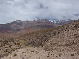 Colangüil as seen from the northeast | |
| Highest point | |
| Elevation | 6,122 m (20,085 ft)[1][2] |
| Prominence | 1,547 metres (5,075 ft) |
| Parent peak | Majadita |
| Coordinates | 29°35′20.75″S 069°26′57.12″W / 29.5890972°S 69.4492000°WCoordinates: 29°35′20.75″S 069°26′57.12″W / 29.5890972°S 69.4492000°W |
| Geography | |
 Colanguil Argentina | |
| Country | Argentina |
| Parent range | , Andes |
| Climbing | |
| First ascent | 15/12/1994 - Pedro Rosell and Humberto Campodónico (Argentina)[3][4] |

Colanguil or Colangüil is a peak in Argentina[5] with an elevation of 6,122 metres (20,085 ft) metres,[6] the highest at . Its territory is within the Argentinean protection areas of Provincial Reserve San Guillermo, located within the territory of the Argentinean province of San Juan, city of Iglesia.[7]
First Ascent[]
Colanguil was first climbed by Pedro Rosell (Argentina) and Humberto Campodónico (Argentina) 15th December 1994.[8][9]
Elevation[]
Other data from available digital elevation models: SRTM yields 6100 metres,[10] ASTER 6076 metres,[11] ALOS 6076 metres[12] and TanDEM-X 6133 metres.[13] The height of the nearest key col is 4575 meters, leading to a topographic prominence of 1547 meters.[14] Colanguil is considered a Mountain Range according to the Dominance System [15] and its dominance is 25.27%. Its parent peak is Majadita and the Topographic isolation is 97.8 kilometers.[16]
References[]
- ^ "Colanguil". Andes Specialists. Retrieved 2020-04-12.
- ^ "Colanguil". Andes Website. Retrieved 2020-06-22.
- ^ "Pyrenaica 182". Pyrenaica 182: 14–19.
- ^ "AAJ". AAJ: 226. 1995.
- ^ Biggar, John (2020). The Andes a guide for climbers (5th ed.). Castle Douglas, Scotland. ISBN 978-0-9536087-7-5. OCLC 1260820889.
- ^ "Capas SIG | Instituto Geográfico Nacional". www.ign.gob.ar. Retrieved 2020-04-30.
- ^ "Capas SIG | Instituto Geográfico Nacional". www.ign.gob.ar. Retrieved 2020-04-30.
- ^ "Pyrenaica 182". Pyrenaica 182: 14–19.
- ^ "AAJ". AAJ: 226. 1995.
- ^ USGS, EROS Archive. "USGS EROS Archive - Digital Elevation - SRTM Coverage Maps". Retrieved 12 April 2020.
- ^ "ASTER GDEM Project". ssl.jspacesystems.or.jp. Retrieved 2020-04-14.
- ^ "ALOS GDEM Project". ALOS EORC Jax Japan. Archived from the original on 2015-07-21. Retrieved 2020-04-14.
- ^ TanDEM-X, TerraSAR-X. "Copernicus Space Component Data Access". Retrieved 12 April 2020.
- ^ "Colanguil". Andes Specialists. Retrieved 2020-04-12.
- ^ "Dominance - Page 2". www.8000ers.com. Retrieved 2020-04-12.
- ^ "Colanguil". Andes Specialists. Retrieved 2020-04-12.
External links[]
- Six-thousanders of the Andes
- Mountains of Argentina