Collectivity of Saint Martin
Saint Martin Saint-Martin | |
|---|---|
| Collectivity of Saint Martin Collectivité de Saint-Martin | |
 Flag | |
| Anthem: "La Marseillaise" | |
Territorial song: "O Sweet Saint Martin's Land" | |
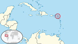 Location of Saint Martin in the Leeward Islands | |
 | |
| Sovereign state | France |
| Partition of island | 23 March 1648 |
| Separated from Guadeloupe | 15 July 2007 |
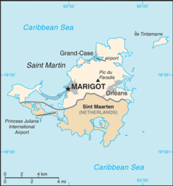
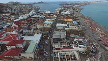
| Capital and largest city | Marigot |
| Official languages | French |
| Demonym(s) | Saint-Martinois |
| Government | Devolved parliamentary dependency |
| Emmanuel Macron | |
• Prefect | Sylvie Feucher |
• President of the Territorial Council | Daniel Gibbs |
| French Parliament | |
• Senate | 1 senator (of 377) |
| 1 seat shared with Saint Barthélemy (of 577) | |
| Area | |
• Total | 53.2 km2 (20.5 sq mi) |
• Water (%) | negligible |
| Population | |
• 2018 census | 34,065[1] |
• Density | 640/km2 (1,657.6/sq mi) |
| GDP (nominal) | 2005 estimate |
• Total | US$599,000,000 |
| Currency |
|
| Time zone | UTC-4:00 (AST) |
| Driving side | right |
| Calling code | +590 |
| ISO 3166 code | |
| Internet TLD | |

The Collectivity of Saint Martin (French: Collectivité de Saint-Martin), commonly known as simply Saint Martin (Saint-Martin), is an overseas collectivity of France in the West Indies in the Caribbean.[2] With a population of 34,065 as of January 2018[1] on an area of 53.2 square kilometres (20.5 sq mi), it encompasses the northern 60% of the divided island of Saint Martin, and some neighbouring islets, the largest of which is Île Tintamarre. The southern 40% of the island of Saint Martin constitutes Sint Maarten, which has been a constituent country of the Kingdom of the Netherlands[2] since 2010. This marks the only place in the world where France borders the Netherlands.
Before 2007, the French region of Saint Martin formed a part of the French overseas department and region of Guadeloupe. Saint Martin is separated from the island of Anguilla by the Anguilla Channel.[3] Its capital is Marigot.[2]
Etymology[]
The island was named by Christopher Columbus in honour of St Martin of Tours because he first sighted it on the saint's feast day on 11 November 1493.[2]
History[]
Pre-colonial[]
Saint Martin was inhabited by Amerindian peoples for many centuries, with archaeological evidence pointing to a human presence on the island as early as 2000 BC.[4] These people most likely migrated from South America.[4] The earliest known people were the Arawak who settled there between 800 and 300 BC.[4] Circa 1300-1400 AD, they began to be displaced by hostile groups of Carib people.[4]
Arrival of Europeans[]

It is commonly believed that Christopher Columbus named the island in honor of Saint Martin of Tours when he encountered it on his second voyage of discovery. However, he actually applied the name to the island now called Nevis when he anchored offshore on 11 November 1493, the feast day of Saint Martin. The confusion of numerous poorly charted small islands in the Leeward Islands meant that this name was accidentally transferred to the island now known as Saint-Martin/Sint Maarten.[5][6]
Nominally a Spanish territory, the island became the focus of the competing interest of the European powers, notably France and the United Provinces. Meanwhile, the Amerindian population began to decline precipitously, dying from diseases brought by the Europeans.
In 1631, the Dutch built Fort Amsterdam on Saint Martin and the Dutch West India Company began mining salt there. Tensions between the Netherlands and Spain were already high due to the ongoing Eighty Years' War, and in 1633 the Spanish captured St Martin and drove off the Dutch colonists. The Dutch, under Peter Stuyvesant, attempted to regain control in 1644 but were unsuccessful.[7] However, in 1648 the Eighty Years' War ended and the island lost its strategic and economic value to Spain. The Spanish abandoned it and the Dutch returned.[4] The French also began settling, and rather than fight for control of the entire island the two powers agreed to divide it in two with the Treaty of Concordia.[8] The first governor of French Saint Martin was Robert de Longvilliers. Various adjustments to the precise alignment of the border occurred, with the boundary settling at its current position by 1817.
18th-19th centuries[]
To work the new cotton, tobacco and sugar plantations the French and Dutch began importing large numbers of African slaves, who soon came to outnumber the Europeans.[4] The French eventually abolished slavery in 1848, followed by the Dutch in 1863 (though after 1848, slavery had scarcely been enforceable as slaves could simply move from the Dutch to the French side of the island).[4] Meanwhile, in 1763, Saint Martin was merged into France's Guadeloupe colony.[4]
20th-21st centuries[]
By the first decades of the 20th century Saint Martin's economy was in a poor state, prompting many to emigrate.[4] Things improved during the Second World War as the Americans built an airstrip on the Dutch side of the island.[4]
In 1946 Saint Martin (along with Saint Barthélemy) was formally subsumed as an arrondissement into the Guadeloupe département.[4] Tourism started expanding from the 1960s-70s onward, eventually becoming the dominant sector of Saint Martin's economy.[4]
Hurricane Luis hit the island in 1995, causing immense destruction and resulting in 12 deaths.[4]
In 2007 Saint Martin was detached from Guadeloupe and became a territorial collectivity with its own Prefect and Territorial Council.[2]
In 2017 Saint Martin was again devastated by a hurricane (Hurricane Irma), causing widespread destruction across the entire island.[9]
Geography[]

The Collectivity of Saint Martin occupies the northern half of the island of Saint Martin in the Leeward Islands; the southern half forms the Dutch territory of Sint Maarten. To the north across the Anguilla Channel lies the British Overseas Territory of Anguilla, to the south-east of the island lies the French island of Saint Barthélemy and further south are the Dutch islands of Saba and Saint Eustatius.
Saint Martin's land area is 53 km2 (20 sq mi).[10] The terrain is generally hilly, with the highest peak being Pic Paradis at 424 m (1,391 ft), which is also the highest peak on the island as a whole.[2] The Terres Basses region lying west of the capital Marigot, which contains the French half of the Simpson Bay Lagoon, is flatter. There are a few small lakes on Saint Martin, such as , Great Pond and Red Pond. The land is part of the Leeward Islands xeric scrub ecoregion.[11]
Numerous small islands lie off the coast, most notably , Creole Rock, , , (within the Simpson Bay Lagoon) and the largest Tintamarre Island.
Hurricane Irma[]
Hurricane Irma hit Saint Martin on 6 September 2017; 95% of the structures on the French side were damaged or destroyed.[9][12] Looting or "pillaging" was a problem initially; France subsequently sent 240 gendarmes to help control the situation.[13][14][15]
On 11 September President Emmanuel Macron visited St Martin to view the damage and to assure residents of support for relief efforts.[16] At that time, only tourists and visitors from France (mainlanders) had been evacuated from St. Martin, leading to complaints by black and mixed-race residents that whites were being given priority.[17] Macron pledged 50 million euros of aid for the French islands and said the rebuilding will be done quickly but very well.[18] By March 2018 much of the territory's infrastructure was back up and running.[19]
Politics and government[]

Saint Martin was for many years a French commune, forming part of Guadeloupe, which is an overseas région and département of France. In 2003 the population of the French part of the island voted in favour of secession from Guadeloupe in order to form a separate overseas collectivity (COM) of France.[2][20] On 9 February 2007, the French Parliament passed a bill granting COM status to both the French part of Saint Martin and (separately) the neighbouring Saint Barthélemy.[21] The new status took effect on 15 July 2007, once the local assemblies were elected,[22] with the second leg of the vote ultimately occurring on 15 July 2007.[23] Saint Martin remains part of the European Union.[24]
The new governance structure befitting an overseas collectivity took effect on 15 July 2007 with the first session of the Territorial Council (French: Conseil territorial). This is a unicameral body of 23 members, with elections held every five years.[3][2] The first President of the Territorial Council was Louis-Constant Fleming, however on 25 July 2008 Fleming resigned after being sanctioned by the Conseil d'État for one year over problems with his 2007 election campaign.[25] On 7 August, was elected as President of the Territorial Council.[26] However, his election was declared invalid on 10 April 2009 and Daniel Gibbs appointed as Acting President of the Territorial Council on 14 April 2009.[27] Gumbs was reelected on 5 May 2009.[28]
The Chief of State is the President of France (currently Emmanuel Macron), who is represented locally by a Prefect appointed by him/her on the advice of the Minister of the Interior (France).[2][3] The current Prefect is Sylvie Feucher.[29] Saint Martin elects one member to the French Senate, and one to the French National Assembly (note that the latter post is shared with Saint Barthélemy).[2]
Before 2007, Saint Martin was coded as GP (Guadeloupe) in ISO 3166-1. In October 2007, it received the ISO 3166-1 code MF (alpha-2 code), MAF (alpha-3 code), and 663 (numeric code).[30]
Demographics[]

Saint Martin has a population of 34,065 (Jan. 2018 census),[1] which means a population density of 640 inhabitants per square kilometre (1,700/sq mi). At the Jan. 2017 French census the population was 35,334[31] (up from only 8,072 inhabitants at the 1982 census). The population decrease between January 2017 and January 2018 is due to Hurricane Irma which affected Saint Martin in early September 2017 and destroyed most of the territory's infrastructure.
Most residents live on the coastal region in the towns of Marigot (the capital), Grand-Case and Quartier-d'Orleans.[2] Most residents are of black or mixed Creole ancestry, with smaller numbers of Europeans and Indians.[2]
French is the official language of the territory.[2] Other languages spoken include English, Dutch, Papiamento and Spanish. A local English-based dialect is spoken in informal situations on both the French and Dutch sides of the island.[32] The sizable Haitian community (7,000 in 2000) also use Haitian Creole.[33]
The main religions are Roman Catholicism, Jehovah's Witnesses, various Protestant denominations and Hinduism.[2]
| 1885 | 1954 | 1961 | 1967 | 1974 | 1982 | 1990 | 1999 | 2007 | 2012 | 2017 | 2018 |
|---|---|---|---|---|---|---|---|---|---|---|---|
| 3,400 | 3,366 | 4,502 | 5,061 | 6,191 | 8,072 | 28,518 | 29,078 | 35,925 | 35,742 | 35,334 | 34,065 |
| Official figures from French censuses. | |||||||||||
Economy[]
As a part of France, the official currency of Saint Martin is the euro,[2] though the US dollar is also widely accepted. Tourism is the main economic activity – with over one million visitors annually some 85% of the population is employed in this sector.[2] The other major sector is the financial services industry.[2] Though limited, agriculture and fishing are also practiced, though these sectors are very small and most food is imported.[2]
INSEE estimated that the total GDP of Saint Martin amounted to 421 million euros in 1999 (US$449 million at 1999 exchanges rates; US$599 million at Oct. 2007 exchange rates).[34] In that same year the GDP per capita of Saint Martin was 14,500 euros (US$15,500 at 1999 exchanges rates; US$20,600 at Oct. 2007 exchange rates), which was 39% lower than the average GDP per capita of metropolitan France in 1999.[34] In comparison, the GDP per capita on the Dutch side of the island, Sint Maarten, was 14,430 euros in 2004.[35]
Education[]
The collectivity has the following public preschool, primary, and elementary schools:[36]
- Preschools: Jean Anselme, Jérôme Beaupère, Elaine Clarke, Evelina Halley, Ghyslaine Rogers, Trott Simeone
- Primary schools: Omer Arrondell, Emile Choisy, Nina Duverly, Elie Gibs, Aline Hanson, Emile Larmonnie, Marie-Amélie Ledee, Clair Saint-Maximin, Hervé Williams
- Ecole élémentaire M-Antoinette Richard
There are three junior high schools (collège) and one senior high school:[37]
- Junior highs: #1 Mont Des Accords, #2 Soualiga, #3 Quartier d'Orleans
- (senior high/sixth-form)
- is a joint public junior-senior high school in Saint Martin
Newspapers[]
The following newspapers are published in Saint Martin:
Transport[]

Saint Martin has one airport – Grand Case-Espérance Airport – which provides flights to Guadeloupe, Martinique and Saint Barthélemy.[44][45] For international tourists Saint Martin relies on Princess Juliana International Airport on the Dutch side of the island.[3]
See also[]
References[]
- ^ Jump up to: a b c INSEE, Government of France. "Populations légales 2018 des départements et collectivités d'outre-mer" (in French). Retrieved 29 January 2021.
- ^ Jump up to: a b c d e f g h i j k l m n o p q r "CIA World Factbook – Saint Martin". Retrieved 24 July 2019.
- ^ Jump up to: a b c d "Encyclopedia Britannica – Saint Martin". Retrieved 24 July 2019.
- ^ Jump up to: a b c d e f g h i j k l m "History of Saint Martin". Retrieved 24 July 2019.
- ^ Hubbard, Vincent K. (2002). A History of St Kitts. MacMillan Caribbean. p. 13. ISBN 0333747607.
- ^ Morison, Samuel Eliot (1974). The European Discovery of America, The Southern Voyages. Oxford University Press. pp. 108-109.
- ^ Caribbean: The Lesser Antilles Karl Luntta
- ^ Henocq, Christophe (15 March 2010), "Concordia Treaty, 23rd March 1648", Heritage, 6: 13, retrieved 17 September 2018
- ^ Jump up to: a b Dutch officials: Irma damaged or destroyed 70 percent of St. Maarten homes, leaving island vulnerable to Jose's approach. The Washington Post 9 September 2017. [1] Accessed 9 September 2017
- ^ INSEE. "2008, An 1 de la collectivitéde Saint-Martin" (PDF) (in French). p. 6. Retrieved 29 January 2021.
- ^ Dinerstein, Eric; et al. (2017). "An Ecoregion-Based Approach to Protecting Half the Terrestrial Realm". BioScience. 67 (6): 534–545. doi:10.1093/biosci/bix014. ISSN 0006-3568.
- ^ Hurricane Irma destroys '95%' of French part of St. Martin—official, Agence France-Presse 7 September 2017. [2] Accessed 9 September 2017
- ^ Whelan, Robbie; Pop, Valentina (9 September 2017). "Looting Reported on Caribbean Island Struck by Hurricane Irma". The Wall Street Journal. Retrieved 3 October 2018.
- ^ "Archived copy". Archived from the original on 8 September 2017. Retrieved 10 September 2017.CS1 maint: archived copy as title (link)
- ^ News, ABC. "International News: Latest Headlines, Video and Photographs from Around the World -- People, Places, Crisis, Conflict, Culture, Change, Analysis and Trends". ABC News. Archived from the original on 13 September 2017. Retrieved 3 October 2018.
- ^ Hilary Clarke; Samantha Beech. "European leaders step up Irma relief effort in Caribbean". CNN. Retrieved 3 October 2018.
- ^ "In Irma's aftermath, Black residents of St. Martin complain France is evacuating white tourists first - The Star". Retrieved 3 October 2018.
- ^ Staff and agencies (12 September 2017). "Emmanuel Macron pledges €50m to help Irma-ravaged Caribbean territories". The Guardian. Retrieved 3 October 2018.
- ^ "Updated: Mapping what's open and closed in the Caribbean: Travel Weekly". travelweekly.com. Archived from the original on 29 April 2018. Retrieved 3 October 2018.
- ^ "French Caribbean voters reject change". Caribbean Net News. 9 December 2003. Archived from the original on 18 March 2009. Retrieved 9 February 2007.
However voters on the two tiny French dependencies of Saint-Barthelemy and Saint-Martin, which have been administratively attached to Guadeloupe, approved the referendum and are set to acquire the new status of "overseas collectivity".
- ^ "Saint-Barth To Become An Overseas Collectivity" (PDF). St. Barth Weekly. 9 February 2007. p. 2. Retrieved 9 February 2007.
- ^ NewMedia. "Les élections du futur conseil territorial font débat - Politique - Ixprim News - NewMedia - Newmedia". newmedia-fr.info. Archived from the original on 18 December 2009.
- ^ See J. P. Thiellay, Droit des outre-mers, Paris:Dalloz, 2007.
- ^ "Consolidated version of the Treaty on the Functioning of the European Union, Article 355". Official Journal of the European Union. 7 June 2016. Retrieved 19 August 2016.
- ^ "Louis-Constant Fleming démissionné par le conseil d'Etat" (in French). fxgpariscaraibe. 28 July 2008. Retrieved 17 August 2008.
- ^ "Frantz Gumbs elected new president of Collectivité". The Daily Herald. 8 August 2008. Archived from the original on 8 July 2011. Retrieved 17 August 2008.
Frantz Gumbs, formerly president of Union Pour le Progrès (UPP) party, swept into power as new president of the Collectivité at an extraordinary meeting of the Territorial Council on Thursday after winning the 23-councillor vote with a clear majority over Marthe Ogoundélé-Tessi.
- ^ "The Daily Herald - New Domain Redirect". thedailyherald.com. Archived from the original on 19 April 2009.
- ^ "May 2009". rulers.org.
- ^ Government of the French Republic (18 June 2018). "Décret du 18 juin 2018 portant nomination de la préfète déléguée auprès du représentant de l'Etat dans les collectivités de Saint-Barthélemy et de Saint-Martin - Mme DANIELO-FEUCHER (Sylvie)". legifrance.gouv.fr (in French). Retrieved 24 April 2020.
- ^ ISO 3166-1 Newsletter. Assignment of code elements for Saint Barthélemy and Saint Martin and update of France and other French Territories
- ^ INSEE, Government of France. "Populations légales 2017 des départements et collectivités d'outre-mer" (in French). Retrieved 29 January 2021.
- ^ Holm (1989) Pidgins and Creoles, vol. 2
- ^ Klomp, Ank. "Saint Martin: Communal Identities on a Divided Caribbean Island." In: Niedermüller, Peter and Bjarne Stoklund (editors). Volume 30:2, 2000: Borders and Borderlands: An Anthropological Perspective. Museum Tusculanum Press, 2000. ISBN 8772896779, 9788772896779. Start: p. 73. CITED: p. 80.
- ^ Jump up to: a b INSEE, CEROM. "Estimation du PIB de Saint-Barthélemy et de Saint-Martin" (PDF) (in French). Retrieved 13 November 2007.
- ^ Total 2004 GDP of Sint Maarten ("Archived copy". Archived from the original on 24 November 2007. Retrieved 14 November 2007.CS1 maint: archived copy as title (link)) divided by the number of inhabitants in 2004 ("Archived copy". Archived from the original on 6 July 2011. Retrieved 14 October 2010.CS1 maint: archived copy as title (link)), then converted from Netherlands Antillean gulden to euro by using the 2004 exchange rate.
- ^ "LISTE DES ECOLES PUBLIQUES ET PRIVEES SOUS CONTRAT." . Retrieved 10 March 2018.
- ^ "Établissements du 2nd degré PUBLIC 2017-2018." . Retrieved 10 March 2018.
- ^ "Qui sommes nous?". lepelican-journal.com. Retrieved 16 September 2020.
- ^ "Contact". Faxinfo. Retrieved 16 September 2020.
- ^ "Contacter la rédaction de SXMINFO". Saint Martin Island | sxminfo.fr (in French). 2 June 2010. Retrieved 16 September 2020.
- ^ "Mentions Légales". SoualigaPost.com (in French). Retrieved 16 September 2020.
- ^ "Politique Editoriale retenue". Le St Martin's Week (in French). Retrieved 16 September 2020.
- ^ "St. Martin News Network - Contact Us". smn-news.com. Retrieved 16 September 2020.
- ^ "St. Martin Tourist Office - Coming to SXM by air or sea". St. Martin Tourist Office. Archived from the original on 25 October 2007.
- ^ "StBarthCommuter.com - L'Espérance Airport, Grand Case (SFG)". Archived from the original on 22 September 2007. Retrieved 24 July 2019.
External links[]
 Definitions from Wiktionary
 Media from Wikimedia Commons
 News from Wikinews
 Quotations from Wikiquote
 Texts from Wikisource
 Textbooks from Wikibooks
 Resources from Wikiversity
- Official website of the Collectivity of Saint Martin (in French)
- Official website of the Tourist Office of Saint Martin
 Wikimedia Atlas of Saint Martin (France)
 Collectivity of Saint Martin travel guide from Wikivoyage
- Saint Martin. The World Factbook. Central Intelligence Agency.


| show Authority control |
|---|

- Collectivity of Saint Martin
- Saint Martin
- Island countries
- Dependent territories in the Caribbean
- French Caribbean
- Overseas collectivities of France
- Outermost regions of the European Union
- French-speaking countries and territories
- Former dependencies of Guadeloupe
- States and territories established in 2007
- 2007 establishments in France
- 2007 establishments in North America