Colombo Street
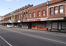
 Colombo Street (left to right) at Hereford Street | |||
| Length | 6.2 km (3.9 mi) | ||
|---|---|---|---|
| Postal code |
8022 (south end to Heathcote River) 8023 (Heathcote River to Moorhouse Ave) 8011 (Moorhouse Ave to Avon River) 8013 (Avon River to Bealey Ave) 8014 (Bealey Ave to north end) | ||
| South end | Dyers Pass Road / Cashmere Road / Centaurus Road roundabout | ||
| North end | Edgeware Road | ||
| Construction | |||
| Construction start | 1851 | ||
Colombo Street is a main road of the city of Christchurch, New Zealand. It runs south-north through the centre of Christchurch with a break at Cathedral Square. As with many other central Christchurch streets, it is named for a colonial Anglican bishopric, Colombo, Sri Lanka in what at the time was known as Ceylon. Parts of the street which run through Sydenham were known as Addison Street during the 1880s, and some parts were known as Colombo Road.[1]
Geography[]
Colombo Street runs for 6.2 kilometres (3.9 mi) due north-south. As with most Christchurch north-south streets, its numbering starts at its southern end. Like most of central Christchurch, the street is flat. It starts 4.0 kilometres (2.5 mi) south of the city centre at a roundabout junction with Dyers Pass Rd, which descends from the Port Hills and Cashmere and Centaurus Roads, which run along the foot of the hills. For its first few hundred metres the street runs north-northeast through the suburb of Somerfield,[2] before turning due north and crossing the Heathcote River in the residential suburb of Beckenham. The suburb of Sydenham starts once Tennyson Street is crossed. Between Tennyson Street and Strickland Street is a suburban shopping centre. Colombo Street crosses the Christchurch ring route (SH 76, at that point called Brougham Street) and enters the commercial/industrial part of Sydenham.
North of Sydenham, Colombo Street crosses the Christchurch-Lyttelton railway line via a flyover then passes beneath the Moorhouse Avenue flyover, entering the Christchurch Central City. It passes the Bus Interchange (until 2011 the Bus Exchange), the city's central bus depot and crosses the major pedestrian mall, City Mall (Cashel Street) before being interrupted by Cathedral Square, the heart of Christchurch. In the square it crosses the loop of the Christchurch tramway circuit, crossing it again two blocks north at Armagh Street. From Armagh Street it skirts the edge of Victoria Square and crosses the Avon River before passing the James Hay Theatre, part of the Christchurch Town Hall.
Colombo Street passes St Mary's Primary School and the former Christchurch Women's Hospital complex (now demolished) before crossing Bealey Avenue and entering the residential suburb of St Albans. The street terminates at Edgeware Road, 2.2 kilometres (1.4 mi) north of Cathedral Square. The highest street number is 1075.
All three remaining[3] Barnes dance intersections in the South Island are on Colombo Street, at the intersections with Armagh, Gloucester, and Hereford Streets. The Colombo / Hereford intersection has the highest pedestrian count. A further Barnes dance is under consideration for Lichfield Street in conjunction with the relocated central city bus exchange.
Notable shopping complexes on Colombo Street include Christchurch's main branch of Farmers, and South City Mall north of Moorhouse Avenue.
History[]
Colombo Street was one of the city's original streets, being laid out at the time of the settlement of Canterbury Province in 1850 by surveyors Joseph Thomas and Edward Jollie.[1]
The street was the site of one of the worst disasters in New Zealand history, with a major fire that swept through the Ballantyne's Department Store in November 1947 killing 41 people. The disaster remains the country's most deadly fire.[4]
Cathedral Square[]
In the original survey of central Christchurch (known as the Black Map), which was undertaken in 1850, it was envisaged for Christ's College and ChristChurch Cathedral to be built adjacent to one another in Cathedral Square, modelled on Christ Church, Oxford.[5] The area set aside for the college in Cathedral Square was found to be insufficient, and Henry Sewell suggested in June 1853 to move the college to land reserved for the Christchurch Botanic Gardens.[6] This transaction was formalised through The Cathedral Square Ordinance 1858, a law passed by the Canterbury Provincial Council in October 1858.[7] The ordinance allowed for Colombo Street to go straight through the middle of Cathedral Square at a legal width of 1.5 chains (99 ft; 30 m), and the cathedral to be placed west of this thoroughfare.[7]
Christianity has adopted the practice of praying towards the East as the Orient was thought of as containing the mankind's original home. Hence, most Christian churches are oriented towards the east,[8][9] and to comply with this convention, Henry Harper, Christchurch's first Bishop, lobbied to have the eastern side of Cathedral Square to be used for the pro-cathedral. That way, the main entrance would face Colombo Street, resulting in praying towards the east in line with convention.[10] The Cathedral Square Amendment Ordinance 1859, which was passed a year after the previous ordinance, formalised the change in placement of the cathedral.[11]

Just before work on the cathedral's foundations began in 1864, the alignment of Colombo Street through Cathedral Square was changed again by introducing a curve towards the west; the western side of the legal road had a radius of 3 chains 75 links (75 m).[12] The purpose of this change was to allow the placement of the cathedral slightly further west, making its tower visible along Colombo Street from a distance.[10]
Until 1965, Colombo Street did not stop at Cathedral Square but continued across it, running across the foot of the cathedral. Several pedestrianisation schemes over the latter part of the century extended the traffic-free area of the central city, and the street was finally stopped from entering the square itself. Recent controversial plans have suggested restoring traffic-flow along the part of Colombo Street which was blocked off in 1965.[13]
Registered heritage buildings[]
Colombo Street contains or contained eleven structures that are registered as Category II historic places by Heritage New Zealand:
| Photo | Name | Status | Address | Description |

|
Rose Historic Chapel | significantly damaged | 866 Colombo Street | chapel of the former St. Mary's Convent[14] |
|
Wharetiki House | demolished | 854 Colombo Street | residential property just north of Salisbury Street[15] |

|
Avon River Bridge | reopened in April 2014 | n/a | road bridge adjacent to and at the north end of Victoria Square[16] |

|
Isaac House | in use | 779 Colombo Street; corner Armagh Street | commercial building south of Victoria Square in Inter War Georgian Revival style[17] |

|
The Union Centre Building (formerly Armstrong's) | demolished | 91-107 Armagh Street | commercial building opposite Isaac House[18] |

|
Beaths Department Store Building | unknown | 682-690 Colombo Street; corner Cashel Mall | these days part of the Bus Exchange[19] |

|
New City Hotel | in use | 527-533 Colombo Street; corner Bath Street | hotel[20] |

|
Sydenham Post Office Building | demolished | 527-533 Colombo Street; corner Brougham Street | restaurant[21] |

|
Sydenham Heritage Church | demolished | 253 Brougham Street | church |

|
Beckenham Baptist Church | demolished | c.146 Colombo Street | church |

|
Old Malthouse | in use | 71 Colombo Street | these days a children's theatre[22] |
Three further Category II structures are located in Victoria Square:
- Queen Victoria Statue, unveiled in 1903[23]
- Cook Statue, donated in 1932 by Matthew Barnett, the owner of Wharetiki (mentioned above)[24]
- Victoria Street Bridge, these days known as the Hamish Hay Bridge, the bridge of the former Victoria Street over the Avon River[25]
Proceeding through Cathedral Square, there are several Category I and II heritage structures, as outlined in the Cathedral Square article.
2010 and 2011 earthquakes[]

Much of Colombo Street through Sydenham was damaged by the 2010 Canterbury earthquake. For several months, the road was only partially open.
Further earthquake damage was caused by the February 2011 Christchurch earthquake. Many of the remaining historic buildings in Sydenham have subsequently been demolished. Buildings between St Asaph Street and Hereford Street suffered major damage, with many having since been removed. Two buses in the section south of Tuam Street were crushed by falling façades.
In total, 19 people were killed in Colombo Street in the February 2011 earthquake; all but one died in the central city:[26]
- two people died in the block between Armagh and Gloucester Streets
- one person died in the block between Lichfield and Tuam Streets
- fifteen people died in the block between Tuam and St Asaph Streets, including eight on Red Bus number 702 (Ann Brower was the sole survivor on that bus)[27]
- one person died in the block between Wordsworth and Elgin Streets in Sydenham
Major intersections[]
| Location | km | mi | Destinations | Notes | |
|---|---|---|---|---|---|
| Cashmere | 0.0 | 0.0 | Centaurus Road – Hillsborough, Lyttelton Dyers Pass Road – Governors Bay Cashmere Road – Princess Margaret Hospital, Halswell | Colombo Street begins | |
| 0.8 | 0.50 | Heathcote River / Ōpāwaho | |||
| Sydenham | 1.2 | 0.75 | Tennyson Street | ||
| 1.3 | 0.81 | Strickland Street | |||
| 1.7 | 1.1 | Beaumont Street | |||
| 2.0 | 1.2 | Milton Street – Spreydon, Halswell Huxley Street – North via City Centre | |||
| 2.3 | 1.4 | ||||
| 2.6 | 1.6 | Wordsworth Street | |||
| 2.9 | 1.8 | Sandyford Street Byron Street | |||
| Sydenham/Christchurch Central boundary | 3.2 | 2.0 | Moorhouse Avenue | ||
| Christchurch Central | 3.6 | 2.2 | Saint Asaph Street | ||
| 3.7 | 2.3 | Tuam Street | |||
| 3.8 | 2.4 | Lichfield Street | |||
| 3.9 | 2.4 | Cashel Street | |||
| 4.0 | 2.5 | Hereford Street High Street | |||
| Interrupted by Cathedral Square | |||||
| 4.4 | 2.7 | Gloucester Street | |||
| 4.5 | 2.8 | Armagh Street | |||
| 4.7 | 2.9 | Avon River / Ōtākaro | |||
| 4.8 | 3.0 | Kilmore Street | |||
| 5.0 | 3.1 | Salisbury Street | |||
| Christchurch Central/Saint Albans boundary | 5.4 | 3.4 | Bealey Avenue | ||
| Saint Albans | 6.2 | 3.9 | Edgeware Road | Colombo Street ends | |
| 1.000 mi = 1.609 km; 1.000 km = 0.621 mi | |||||
Notes[]
- ^ a b Harper, Margaret. "Christchurch Street Names C" (PDF). Christchurch City Libraries. Retrieved 3 November 2010.
- ^ Harper, Margaret. "Christchurch Place Names" (PDF). Christchurch City Libraries. p. 167. Archived from the original (PDF) on 22 February 2012. Retrieved 27 March 2010.
- ^ A Barnes dance in South Dunedin was removed in the mid 1990s.
- ^ Fraser, B. (ed.) (1986) The New Zealand book of events. Auckland: Reed Methuen. ISBN 0-474-00123-7. p. 433.
- ^ Wigram 1916, p. 147.
- ^ Sewell 1980, pp. 306f.
- ^ a b "Session X 1858 (October to December 1858)" (PDF). Christchurch City Libraries. pp. 12–14. Retrieved 1 May 2014.
- ^ "Orientation of Churches". Catholic Encyclopedia. Retrieved 3 December 2013.
- ^ Peters, Bosco (30 April 2012). "Architectural Design Guidelines 1". Liturgy.co.nz. Retrieved 3 December 2013.
- ^ a b Wigram 1916, p. 148.
- ^ "Session XI 1859 (September 1859 to January 1860)" (PDF). Christchurch City Libraries. pp. 7f. Retrieved 1 May 2014.
- ^ "Session XXII 1864 (August to September 1864)" (PDF). Christchurch City Libraries. pp. 8f. Retrieved 1 May 2014.
- ^ Gates, Charlie (27 October 2010). "Leaders back Square revamp". The Press. Retrieved 25 September 2011.
- ^ "Rose Historic Chapel". Register of Historic Places. Heritage New Zealand. Retrieved 25 April 2011.
- ^ "Wharetiki House". Register of Historic Places. Heritage New Zealand. Retrieved 25 April 2011.
- ^ "Avon River Bridge". Register of Historic Places. Heritage New Zealand. Retrieved 25 April 2011.
- ^ "Isaac House". Register of Historic Places. Heritage New Zealand. Retrieved 25 April 2011.
- ^ "Union Centre Building". Register of Historic Places. Heritage New Zealand. Retrieved 10 August 2011.
- ^ "Beaths Department Store Building". Register of Historic Places. Heritage New Zealand. Retrieved 25 April 2011.
- ^ "New City Hotel". Register of Historic Places. Heritage New Zealand. Retrieved 25 April 2011.
- ^ "Sydenham Post Office Building". Register of Historic Places. Heritage New Zealand. Retrieved 25 April 2011.
- ^ "Old Malthouse". Register of Historic Places. Heritage New Zealand. Retrieved 25 April 2011.
- ^ "Queen Victoria Statue". Register of Historic Places. Heritage New Zealand. Retrieved 25 April 2011.
- ^ "Cook Statue". Register of Historic Places. Heritage New Zealand. Retrieved 25 April 2011.
- ^ "Victoria Street Bridge". Register of Historic Places. Heritage New Zealand. Retrieved 25 April 2011.
- ^ Lynch, Keith (21 May 2011). "22/2 Those we lost". The Press. pp. C12–C13.
- ^ "Colombo Street's lone survivor has sparked policy change". Architecture Now. Retrieved 29 April 2018.
References[]
| Wikimedia Commons has media related to Colombo Street. |
- Sewell, Henry (1980). W. David McIntyre (ed.). The Journal of Henry Sewell 1853–7 : Volume I. Christchurch: Whitcoulls Publishers. ISBN 0-7233-0624-9.
- Wigram, Henry (1916). The Story of Christchurch, New Zealand. Christchurch: Lyttelton Times.
- Streets in Christchurch
- Christchurch Central City
- Shopping districts and streets in New Zealand