Columbia Bar
The Columbia Bar, also frequently called the Graveyard of the Pacific, is a system of bars and shoals at the mouth of the Columbia River spanning the U.S. states of Oregon and Washington. It is known as one of the most dangerous bar crossings in the world. The bar is about 3 miles (5 km) wide and 6 miles (10 km) long.[1]
Description[]
The bar is where the river's current dissipates into the Pacific Ocean, often as large standing waves. The waves are partially caused by the deposition of sediment as the river slows, as well as mixing with ocean waves. The waves, wind, and current are hazardous for vessels of all sizes. The Columbia current varies from 4 to 7 knots (7.4 to 13.0 km/h) westward, and therefore into the predominantly westerly winds and ocean swells, creating significant surface conditions.[2][3] Unlike other major rivers, the current is focused "like a fire hose" without the benefit of a river delta.[4] Conditions can change from calm to life-threatening in as little as five minutes due to changes of direction of wind and ocean swell.[5] Since 1792, approximately 2,000 large ships have sunk in and around the Columbia Bar, and because of the danger and the numerous shipwrecks the mouth of the Columbia River acquired a reputation worldwide as the graveyard of the Pacific.[6]
The navigational channel is 2,640 feet (805 m) wide at the west end and narrows to 600 feet (183 m) within the jetties (though the jetties themselves are never closer than two miles (3.2 km) apart). The channel is dredged to 55 feet (17 m) in the northern three-quarters and 48 feet (15 m) for the southern quarter. Inside the bar, the channel remains 600 feet (180 m) wide and reduces to 43 feet (13 m) deep.[1] The Clatsop Spit juts into the ocean on the south side of the river mouth, and on the north side is Peacock Spit, named after the USS Peacock which wrecked there in 1841.[7]
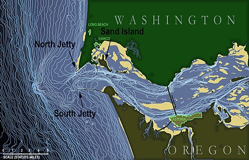
In 1884, after decades of shipwrecks, the United States Corps of Engineers built the south jetty to keep the channel navigable. In 1914, the north jetty was added.[7]
The nearby United States Coast Guard Station Cape Disappointment, Washington, is renowned for operating in some of the roughest sea conditions in the world, and is home to the National Motor Lifeboat School. It is the only school for rough weather and surf rescue operation in the US, and is respected internationally as a center of excellence for heavy boat operations.[8]
Approximately 16 bar pilots, earning about $180,000 per year, guide ships across the bar, often boarding ships by helicopter.[9] They generally consider "the bar" to be the area between the north and south jetties and Sand Island (see detail of bathymetric map for locations of these).
The Columbia Bar is part of a set of major marine coastal hazards along the Pacific Northwest coast, including Cape Flattery at the northwest tip of the Olympic Peninsula and Cape Scott, which is at the north tip of Vancouver Island. Historically, the region's mariner's nickname was the Graveyard of the Pacific, and it is studded with thousands of shipwrecks. The "Graveyard" also includes the rocky, rugged shoreline of the west coast of Vancouver Island, the shores of the Olympic Peninsula, and the Strait of Juan de Fuca.[10][11]
Viewing[]
The most accessible place to watch ships cross the bar is at the South Jetty viewing platform at Fort Stevens State Park located near Warrenton, Oregon. This is also the north end of the Oregon Coast Trail. A more dramatic view can be found by hiking the steep 0.75-mile (1.21 km) trail to the Cape Disappointment Lighthouse at the Cape Disappointment State Park located in Ilwaco, Washington.

See also[]
- King & Winge (bar pilot boat from 1924 to 1958).
- U.S. lightship Columbia, historic navigational aid into the Columbia River.
- Rabboni, first regular steam tug to bring a ship across the Columbia bar.
- SS Iowa, wrecked on Columbia Bar in 1936.
- Rosecrans, wrecked on Columbia Bar in 1913.
References[]
- ^ Jump up to: a b "Pilotage Grounds". Columbia River Bar Pilots. Retrieved 2010-04-18.
- ^ "Graveyard of the Pacific". Long Beach Peninsula Visitors Bureau. Archived from the original on 2007-09-28. Retrieved 2010-04-18.
- ^ Fisherman interviewed in Pacific Graveyard television documentary on The Travel Channel [1][permanent dead link]
- ^ David Wilma (September 12, 2006). "Graveyard of the Pacific: Shipwrecks on the Washington Coast". Retrieved 2010-04-18.
- ^ "Boating in Oregon Coastal Waters—Columbia River" (PDF). Oregon State Marine Board. p. 2. Archived from the original (PDF) on 2010-05-28. Retrieved 2010-04-18.
- ^ "Guarding the Graveyard of Ships." Popular Mechanics, May 1954, p. 128.
- ^ Jump up to: a b McNair-Huff, Rob & Natalie. Washington Disasters. Rowman & Littlefield. pp. 7–10. ISBN 978-1-4930-1322-7.
- ^ Coast Guard station Cape Disappointment website
- ^ Jacklet, Ben (2004-10-19). "Columbia pilot pay attracts port's eye". Portland Tribune. Archived from the original on 2012-02-06. Retrieved 2007-06-14.
- ^ Russell Saddler (January 29, 2006). "Graveyard of the Pacific; Gateway to the Northwest". Blue Oregon. Retrieved 2007-06-28.
- ^ Fred Rogers (1992). More Shipwrecks of British Columbia. Heritage House—Douglas & McIntyre. ISBN 1-55054-020-3. Archived from the original on 2007-06-26. Retrieved 2007-06-29.
External links[]
- "Rough Bar" photos at Columbia River Bar Pilots website
- Columbia River Bar Pilots Video produced by Oregon Field Guide
| Authority control: National libraries |
|---|

- Columbia River
- Landforms of Pacific County, Washington
- United States Coast Guard bases
- Landforms of Clatsop County, Oregon
- Shoals of the United States