Cons-Sainte-Colombe
Cons-Sainte-Colombe | |
|---|---|
Part of Val-de-Chaise | |
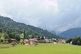 A general view of Cons-Sainte-Colombe | |
show Location of Cons-Sainte-Colombe | |
 Cons-Sainte-Colombe | |
| Coordinates: 45°44′59″N 6°19′36″E / 45.7497°N 6.3267°ECoordinates: 45°44′59″N 6°19′36″E / 45.7497°N 6.3267°E | |
| Country | France |
| Region | Auvergne-Rhône-Alpes |
| Department | Haute-Savoie |
| Arrondissement | Annecy |
| Canton | Faverges |
| Commune | Val-de-Chaise |
| Area 1 | 3.47 km2 (1.34 sq mi) |
| Population (2017)[1] | 387 |
| • Density | 110/km2 (290/sq mi) |
| Demonym(s) | Colombins / Colombines |
| Time zone | UTC+01:00 (CET) |
| • Summer (DST) | UTC+02:00 (CEST) |
| Postal code | 74210 |
| Elevation | 479–2,063 m (1,572–6,768 ft) |
| 1 French Land Register data, which excludes lakes, ponds, glaciers > 1 km2 (0.386 sq mi or 247 acres) and river estuaries. | |


Cons-Sainte-Colombe was a commune in the Haute-Savoie department in the Rhône-Alpes region in south-eastern France. On 1 January 2016 it was merged with Marlens to create the new commune Val-de-Chaise.[2] Its population was 387 in 2017.[1]
See also[]
References[]
- ^ Jump up to: a b Téléchargement du fichier d'ensemble des populations légales en 2017, INSEE
- ^ "Archived copy". Archived from the original on 2016-12-21. Retrieved 2016-01-23.CS1 maint: archived copy as title (link)
| Wikimedia Commons has media related to Cons-Sainte-Colombe. |
This Haute-Savoie geographical article is a stub. You can help Wikipedia by . |
Categories:
- Former communes of Haute-Savoie
- Populated places disestablished in 2016
- Haute-Savoie geography stubs