Cortlandt Street station (IRT Sixth Avenue Line)
Cortlandt St. | ||||||||||||||||
|---|---|---|---|---|---|---|---|---|---|---|---|---|---|---|---|---|
| Former Manhattan Railway elevated station | ||||||||||||||||
 The station platform ca. 1893 | ||||||||||||||||
| Location | Cortlandt Street and Church Street New York, NY Lower Manhattan, Manhattan | |||||||||||||||
| Coordinates | 40°42′37.3″N 74°0′40.46″W / 40.710361°N 74.0112389°WCoordinates: 40°42′37.3″N 74°0′40.46″W / 40.710361°N 74.0112389°W | |||||||||||||||
| Operated by | Interborough Rapid Transit Company | |||||||||||||||
| Line(s) | Sixth Avenue Line | |||||||||||||||
| Platforms | 2 side platforms | |||||||||||||||
| Tracks | 3 | |||||||||||||||
| Construction | ||||||||||||||||
| Structure type | Elevated | |||||||||||||||
| History | ||||||||||||||||
| Opened | June 5, 1878 | |||||||||||||||
| Closed | December 4, 1938[1] | |||||||||||||||
| Former services | ||||||||||||||||
| ||||||||||||||||

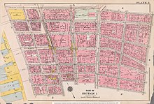
Cortlandt Street station on a map published in 1916
Cortlandt Street was a station at Church Street on the demolished IRT Sixth Avenue Line in Manhattan, New York City. It had 3 tracks and two side platforms. It was served by trains from the IRT Sixth Avenue Line and opened on June 5, 1878. It closed on December 4, 1938. The next southbound stop was Rector Street. The next northbound stop was Park Place.
References[]
- ^ "Days of Yore Recalled as 'L' Line Goes". Rochester Democrat and Chronicle. December 5, 1938. p. 9. Retrieved June 30, 2019 – via Newspapers.com.

This Manhattan train station–related article is a stub. You can help Wikipedia by . |
Categories:
- IRT Sixth Avenue Line stations
- Railway stations in the United States opened in 1878
- Railway stations closed in 1938
- Former elevated and subway stations in Manhattan
- Defunct New York City Subway stations located aboveground
- 1878 establishments in New York (state)
- 1938 disestablishments in New York (state)
- Manhattan railway station stubs