From Wikipedia, the free encyclopedia
Cadastral in Queensland, Australia
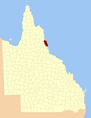
The county of Nares is a cadastral division of Queensland which contains the city of Cairns , Innisfail and most of the Atherton Tableland .[1] George Nares (1831–1915), a naval officer and commander of HMS Salamander .[2] 1911 Britannica .[3] Daintree River in the north.[4]
Parishes [ ] Nares is subdivided into parishes, listed as follows:
Barron
Tablelands 17°15′S 145°29′E / 17.250°S 145.483°E / -17.250; 145.483 (Barron Parish ) Atherton , Tolga
Bartle Frere
Tablelands 17°25′S 145°45′E / 17.417°S 145.750°E / -17.417; 145.750 (Bartle Frere Parish )
Bellenden Ker
Cairns 17°20′S 145°53′E / 17.333°S 145.883°E / -17.333; 145.883 (Bellenden Ker Parish ) Babinda , Bellenden Ker , Miriwinni
Cairns
Cairns 16°53′S 145°40′E / 16.883°S 145.667°E / -16.883; 145.667 (Cairns Parish ) Cairns , Kuranda
Danbulla Tablelands 17°07′S 145°36′E / 17.117°S 145.600°E / -17.117; 145.600 (Danbulla Parish )
Dinden
Mareeba 17°00′S 145°34′E / 17.000°S 145.567°E / -17.000; 145.567 (Dinden Parish )
Dirran
Tablelands 17°30′S 145°37′E / 17.500°S 145.617°E / -17.500; 145.617 (Dirran Parish ) Tarzali , Millaa Millaa
Dulanban
Cairns 16°40′S 145°33′E / 16.667°S 145.550°E / -16.667; 145.550 (Dulanban Parish )
East Barron
Tablelands 17°19′S 145°33′E / 17.317°S 145.550°E / -17.317; 145.550 (East Barron Parish ) Yungaburra
Formartine
Mareeba 16°52′S 145°29′E / 16.867°S 145.483°E / -16.867; 145.483 (Formartine Parish )
Gadgarra
Tablelands 17°15′S 145°44′E / 17.250°S 145.733°E / -17.250; 145.733 (Gadgarra Parish )
Glady
Cassowary Coast 17°28′S 145°56′E / 17.467°S 145.933°E / -17.467; 145.933 (Glady Parish ) Flying Fish Point
Grafton
Cairns 17°05′S 145°44′E / 17.083°S 145.733°E / -17.083; 145.733 (Grafton Parish ) Edmonton , Gordonvale
Hull
Cassowary Coast 17°47′S 146°00′E / 17.783°S 146.000°E / -17.783; 146.000 (Hull Parish ) Silkwood , South Mission Beach , El Arish
Japoon
Cassowary Coast 17°44′S 145°55′E / 17.733°S 145.917°E / -17.733; 145.917 (Japoon Parish ) Japoon
Johnstone
Cassowary Coast 17°36′S 145°55′E / 17.600°S 145.917°E / -17.600; 145.917 (Johnstone Parish ) Innisfail , South Johnstone
Jordan
Cassowary Coast 17°39′S 145°45′E / 17.650°S 145.750°E / -17.650; 145.750 (Jordan Parish )
Malanda
Tablelands 17°22′S 145°37′E / 17.367°S 145.617°E / -17.367; 145.617 (Malanda Parish ) Malanda
Monamona
Mareeba 16°46′S 145°30′E / 16.767°S 145.500°E / -16.767; 145.500 (Monamona Parish )
Mourilyan
Cassowary Coast 17°37′S 146°03′E / 17.617°S 146.050°E / -17.617; 146.050 (Mourilyan Parish ) Mourilyan , parts of Innisfail
Palmerston
Cassowary Coast 17°34′S 145°45′E / 17.567°S 145.750°E / -17.567; 145.750 (Palmerston Parish )
Russell
Cairns 17°19′S 145°59′E / 17.317°S 145.983°E / -17.317; 145.983 (Russell Parish ) Bramston Beach
Smithfield
Tablelands 16°46′S 145°38′E / 16.767°S 145.633°E / -16.767; 145.633 (Smithfield Parish ) Northern Beaches
Sophia
Cairns 17°07′S 145°52′E / 17.117°S 145.867°E / -17.117; 145.867 (Sophia Parish ) Aloomba
Tinaroo
Mareeba 17°04′S 145°25′E / 17.067°S 145.417°E / -17.067; 145.417 (Tinaroo Parish ) Mareeba , Walkamin
Trinity
Cairns 16°58′S 145°49′E / 16.967°S 145.817°E / -16.967; 145.817 (Trinity Parish ) Yarrabah
References [ ] External links [ ] Coordinates : 16°55′S 145°47′E / 16.917°S 145.783°E / -16.917; 145.783
Hidden categories:
Wikipedia articles incorporating a citation from the 1911 Encyclopaedia Britannica with Wikisource reference Webarchive template wayback links Use Australian English from August 2019 All Wikipedia articles written in Australian English Use dmy dates from August 2019 Lists of coordinates Geographic coordinate lists Articles with Geo Articles with short description Short description matches Wikidata Coordinates on Wikidata

![[1]](https://gisservices.information.qld.gov.au/arcgis/rest/directories/historicalscans/cad_scans/cad-map-2mile-county-nares-1919.jpg)