Coyote Lake (San Bernardino County, California)
| Coyote Dry Lake | |
|---|---|
 | |
 Coyote Dry Lake | |
| Location | Mojave Desert San Bernardino County, California |
| Coordinates | 35°04′13″N 116°45′17″W / 35.0702°N 116.7547°WCoordinates: 35°04′13″N 116°45′17″W / 35.0702°N 116.7547°W |
| Lake type | Endorheic basin |
| Primary outflows | Terminal |
| Basin countries | United States |
| Max. length | 10 km (6.2 mi) |
| Max. width | 6 km (3.7 mi) |
| Shore length1 | 30 km (19 mi) |
| Surface elevation | 515 m (1,690 ft) |
| References | U.S. Geological Survey Geographic Names Information System: Coyote Lake |
| 1 Shore length is not a well-defined measure. | |


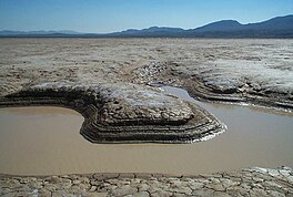
Coyote Dry Lake is a dry lake bed in the Mojave Desert of San Bernardino County, California, 15 mi (24 km) northeast of Barstow. The lake is approximately 10 km (6.2 mi) by 6 km (3.7 mi) at its widest point.
Coyote Dry Lake lies to the south of Fort Irwin Military Reservation and southwest of the Tiefort Mountains. St. Antony's Monastery is located about 4 mi (6.4 km) to the southeast.
Numerous meteorites have been found on the lake bed.[1]
In media[]
This article contains a list of miscellaneous information. (September 2020) |
- In 1975, the cult classic science fiction film A Boy and His Dog was made near this lake.
- In 2000, the Chilean rock band La Ley shot the music video for the hit single "Aquí", which is included in their album Uno. The album's cover art features the band members at the location.
- It is believed that in 2006, Daft Punk shot scenes at this location for their 2006 Movie, “Electroma”
- In 2016, the a cappella group Pentatonix shot the music video for their cover of "Hallelujah", originally performed by Leonard Cohen.
- In 2017, reggaetón performer Yandel shot the music video for his single "Mi Religión" at the location.
- In 2020, global pop group Now United shot their music video for their single "Come Together" at the location.
See also[]
- List of lakes in California
Notes[]
References[]
- Allan, Stuart (2005). California Road and Recreation Atlas. Benchmark Maps. p. 96. ISBN 0-929591-80-1.
External links[]
- U.S. Geological Survey Geographic Names Information System: Coyote Lake (San Bernardino County, California)
- Satellite Photo (Google Maps)
This San Bernardino County, California–related article is a stub. You can help Wikipedia by . |
Categories:
- Lakes of the Mojave Desert
- Endorheic lakes of California
- Salt flats of California
- Lakes of San Bernardino County, California
- Natural history of the Mojave Desert
- Lakes of California
- Landforms of San Bernardino County, California
- Lakes of Southern California
- San Bernardino County, California geography stubs