Creux du Van
This article needs additional citations for verification. (December 2015) |
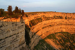

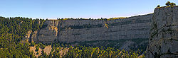
The Creux du Van is a natural rocky cirque approximately 1,400 metres wide and 150 metres deep, on the north side of Le Soliat.[1] It is located in the Val de Travers district, in the Swiss canton of Neuchâtel. A very well known, amphitheatre-shaped natural attraction of the area, it is located at the heart of a nature reservation area of 15.5 km².
Geology[]
The rock arch of Creux du Van was created in 3 phases:
Phase 1: A glacier was covering the area of todays Val de Travers around 140 million years ago (Würm Ice Age). The river stream of the melt water eroded material, making a V-shaped valley.
Phase 2: During new ice ages, other glaciers were created and hollowed out the valley. In warmer periods, the material was eroded by the meltwater.
Phase 3: After the removal of the rocks from the geological fault, another stronger layer from a different age makes the erosion much slower.[2]
See cirque for a description of the process forming features like this.
Attraction[]
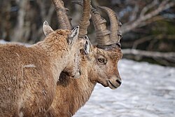
Ibex were introduced in the area in 1965. As of 2009, there are 17.[citation needed]
Access[]
The summit area can be reached on foot or by car. A paved road from Saint-Aubin-Sauges (on Lake Neuchâtel) or Couvet (Val-de-Travers) climbs to la ferme du Soliat (1,382 m), which is located a few minutes walk away from the summit of the rocky cirque. Some hiking paths are indicated, via les petites Fauconnières.
Notable trails in the areas include:
- Le sentier des quatorze contours (the path of the 14 bends) is a reputed itinerary that starts in Noiraigue (Val-de-Travers).
- Le sentier du Single leads to the summit directly from the area called La ferme Robert.
- Other paths, however unmarked, allow the access to the summit via la crête du Dos d'Ane or also from la Fontaine Froide via le Pertuis de Bise (a breach into the wall of rocks).
Panorama[]

References[]
- Creux du Van (Canton of Neuchâtel Tourist Office)
Notes[]
- ^ Creux du Van (1:25,000) (Map). Swisstopo. Retrieved 2015-02-08.
- ^ Switzerland by Locals: Three Top Excursions To The Creux Du Van You Don’t Want To Miss
Coordinates: 46°55′57″N 6°43′25″E / 46.93250°N 6.72361°E
| Authority control |
|---|
- Tourist attractions in Switzerland
- Mountains of the canton of Neuchâtel
- Cirques of Europe
- Mountains of Switzerland