Crikvenica
Crikvenica | |
|---|---|
| Grad Crikvenica Town of Crikvenica | |
 Crikvenica | |
 Crikvenica Location of Crikvenica within Croatia | |
| Coordinates: 45°10′N 14°41′E / 45.167°N 14.683°E | |
| Country | |
| County | |
| Government | |
| • Mayor | Damir Rukavina (HDZ) |
| • City Council | |
| Elevation | 0 m (0 ft) |
| Population (2011) | |
| • Total | 11,122 |
| Time zone | UTC+1 (CET) |
| • Summer (DST) | UTC+2 (CEST) |
| Postal code | 51 260 |
| Area code(s) | 051 |
| Website | www |

Crikvenica (Croatian pronunciation: [ˈtsrikvɛnitsa]) is a city in Croatia, located on the Adriatic in the Primorje-Gorski Kotar County.
Names[]
The names of the town in various languages include:[2]
- Latin: Ad Turres
- Italian: Cirquenizza
- Hungarian: Cirkvenica, Cirkvenicza, Czirkvenicza, Czirkwenicza
- German: Cirknenz
Geography[]
Crikvenica is located southeast of Rijeka and is the largest settlement on the coast of the Vinodol coastal area.
Towns near Crikvenica include Kraljevica, Selce and Novi Vinodolski.
In the last twenty years, due to urban expansion of Crikvenica itself and expansion of the nearby town of Selce, the two were merged into a mini-conglomerate.
Population[]
In the 2011 census, Crikvenica had a total municipal population of 11,122, in the following settlements:[3][4]
- Crikvenica, population 6,860
- Dramalj, population 1,485
- Jadranovo, population 1,224
- Selce, population 1,553
History[]
Crikvenica was developed on the site of a Roman era settlement and military base called Ad Turres.
Old Crikvenica was originally an offshoot of the village of Kotor, which is located on a nearby hill and shares its name with that of the village.
The name of the town derives from the word for 'church' (Croatian: crkva, in dialect crikva), referring to the monastery church of the Pauline Fathers, which was built by Nikola IV Frankopan nearby in 1412. Beside the church and the monastery at the mouth of the , the nearby port of Grižane grew up. In 1760 the local worthy moved from Bribir to Crikvenica and thus it became the centre of the whole Vinodol coast. A great fire of 1776, in which nearly entire Kotor was burnt down, accelerated the migration from the hills towards the coastal areas.[5]
In the 19th century Crikvenica began to attract many tourists, which brought about a turning point in its history. In 1877 a harbour was built in Crikvenica, in 1888 a bathing beach and as early as 1891 the first hotel had opened. In 1895 the Hotel Therapia was opened with 120 beds and a Hydrotherapy Institute. In 1902 the Hotel Crikvenica was built, in 1903 the Bellevue and in 1905 the Miramare. In 1906 Crikvenica became officially a health resort and due to its favourable climate, in the space of just 16 years Crikvenica became the most important resort on the riviera.[6] Today, together with Selce, it is one of the most attractive parts of the Kvarner coast, as well as of the North Adriatic coast of Croatia in general.
In the late 19th and early 20th century, Crikvenica was a district capital in the Modruš-Rijeka County of the Kingdom of Croatia-Slavonia.
Notable people[]
- Josif Pančić (1814–1888), botanist
- Ljerko Spiller (1908–2008), Croatian and Argentine violinist
- The family of Argentine Cardinal Estanislao Esteban Karlic (born 1926) came from Karlići, a small village approximately 5 kilometers (3.1 mi) outside Crikvenica[7]
Photo gallery[]

Viaduct passing through the town
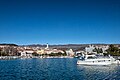
Port of Crikvenica

Town park

Dramalj

Nighttime view of the town

Crikvenica Town Hall
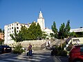
Monastery (today Kaštel Hotel) and Church of the Assumption of the Blessed Virgin Mary
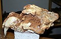
Cave lion skull found in Vrtare Male cave


See also[]
References[]
This article needs additional citations for verification. (December 2014) |
- ^ "Konačni rezultati izbora" (in Croatian). Retrieved 31 May 2017.
- ^ Richard Talbert, Barrington Atlas of the Greek and Roman World, (ISBN 0-691-03169-X), Map 20, notes.
- ^ "Population by Age and Sex, by Settlements, 2011 Census: Crikvenica". Census of Population, Households and Dwellings 2011. Zagreb: Croatian Bureau of Statistics. December 2012.
- ^ "Population by Ethnicity, by Towns/Municipalities, 2011 Census: County of Primorje-Gorski kotar". Census of Population, Households and Dwellings 2011. Zagreb: Croatian Bureau of Statistics. December 2012.
- ^ Bašić 2009, p. 5.
- ^ Naklada Naprijed, The Croatian Adriatic Tourist Guide, pg. 27, Zagreb (1999), ISBN 953-178-097-8
- ^ "Karlić: Nikada nemojte zaboraviti svoje podrijetlo i svoje običaje". Jutarnji list (in Croatian). 2008-02-17. Archived from the original on 2010-03-01. Retrieved 2011-01-18.
Bibliography[]
- Bašić, Martina (2009). "Crikvenička toponimija" [The toponymy of Crikvenica] (PDF). Folia onomastica Croatica (in Croatian) (18): 1–52. Retrieved 10 September 2020.
External links[]
| Wikimedia Commons has media related to Crikvenica. |
| show Subdivisions of Primorje-Gorski Kotar County |
|---|

Coordinates: 45°11′N 14°42′E / 45.183°N 14.700°E
| show Authority control |
|---|
- Cities and towns in Croatia
- Populated coastal places in Croatia
- Roman towns and cities in Croatia
- Populated places in Primorje-Gorski Kotar County
- Modruš-Rijeka County
- 1412 establishments in Europe
- 15th-century establishments in Croatia