Crusheen
Crusheen
Croisín | |
|---|---|
Village | |
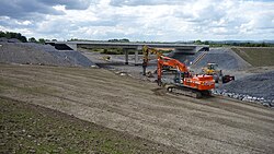 Work on the M18, that took much of the non-local traffic away from the village after completion | |
 Crusheen Location in Ireland | |
| Coordinates: 52°56′23″N 8°53′50″W / 52.939703°N 8.897194°W | |
| Country | Ireland |
| Province | Munster |
| County | County Clare |
| Population (2011) | |
| • Village | 865 [1] |
| • Urban | 467 |
| • Rural | 398 |
| Time zone | UTC+0 (WET) |
| • Summer (DST) | UTC-1 (IST (WEST)) |

Crusheen (Irish: Croisín, meaning "the little cross") is a small village in County Clare, Ireland, in the Catholic parish of Crusheen (Inchicronan).
Location[]
The village is 10 kilometres northeast of Ennis on the R458 road to Gort. It is in the parish of Crusheen (Inchicronan) in the Roman Catholic Diocese of Killaloe. The parish church of St Cronan is in Crusheen.[2] The village consists of the church, Garda station, two public houses, post office, a supermarket, petrol station, funeral home. There is also a primary school [3] and a community centre. The local GAA club is Crusheen GAA.
The main RTÉ Television and Radio Transmitter at Maghera mountain is located east-northeast of the village.
Bordering villages to Crusheen are Barefield, Ballinruan, and Ruan.
According to the latest Census results, Crusheen had a population growth of 20% in the period 2006-2011. In numbers, the population went up from 720 to 864.[4]
Transport[]
- Iarnród Éireann is in talks with a developer to provide a railway station in the village along the Galway - Ennis - Limerick Railway Line - Western Rail Corridor.[citation needed]
- The M18 Motorway passes west of the village and provides a connection with Galway, Ennis, Limerick and Shannon Airport.
- Bus Éireann provides an hourly service with line 51.
Notable people[]
- Kieren Fallon - jockey
- Eddie Lenihan - author and storyteller
References[]
- ^ Population and Actual and Percentage Change 2006 and 2011 by Electoral Division, Statistical Indicator and Year Last visited 23 April 2012.
- ^ "Crusheen (Inchicronan)". Diocese of Killaloe. Archived from the original on 4 March 2016. Retrieved 31 March 2014.
- ^ http://www.crusheenns.com/[bare URL]
- ^ Population and Actual and Percentage Change 2006 and 2011 by Electoral Division, Statistical Indicator and Year Last visited 23 April 2012.
| hide Places in County Clare | ||
|---|---|---|
| Towns |  | |
| Villages |
| |
| Regions | ||
| Islands | ||
| ||
Coordinates: 52°56′22.93″N 8°53′49.9″W / 52.9397028°N 8.897194°W
- Towns and villages in County Clare