Cucalón, Aragon
Cucalón | |
|---|---|
 Flag  Coat of arms | |
 Cucalón | |
| Coordinates: 41°5′N 1°13′W / 41.083°N 1.217°WCoordinates: 41°5′N 1°13′W / 41.083°N 1.217°W | |
| Country | Spain |
| Autonomous community | Aragon |
| Province | Teruel |
| Comarca | Jiloca |
| Area | |
| • Total | 31.87 km2 (12.31 sq mi) |
| Elevation | 1,036 m (3,399 ft) |
| Population (2018)[1] | |
| • Total | 80 |
| Time zone | UTC+1 (CET) |
| • Summer (DST) | UTC+2 (CEST) |

Cucalón is a municipality located in the province of Teruel, Aragon, Spain. According to the 2010 census the municipality has a population of 102 inhabitants.[2] This town gives its name to the Sierra de Cucalón system of mountain ranges.
There are ruins of an ancient Iberian settlement, known as Peña el Castillo, located within Cucalón's municipal term.[3]
Gallery[]

Street in Cucalón with the remains of Santiago church
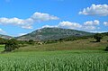
La Modorra, highest point in the Sierra de Cucalón system


See also[]
- Jiloca Comarca
- List of municipalities in Teruel
References[]
- ^ Municipal Register of Spain 2018. National Statistics Institute.
- ^ Instituto Nacional de Estadística (Spain)
- ^ GEA - Huerva, valle de la
External links[]
| Wikimedia Commons has media related to Cucalón. |
- Cucalón, Jiloca[permanent dead link]
- Cucalón
- Sierra de Cucalón
- Guía general de las sierras de Cucalón, Oriche y Fonfría
This article about a location in the Province of Teruel is a stub. You can help Wikipedia by . |
Categories:
- Municipalities in the Province of Teruel
- Province of Teruel geography stubs