Dąbie, Greater Poland Voivodeship
Dąbie | |
|---|---|
 Town hall | |
 Coat of arms | |
 Dąbie | |
| Coordinates: 52°5′19″N 18°49′32″E / 52.08861°N 18.82556°ECoordinates: 52°5′19″N 18°49′32″E / 52.08861°N 18.82556°E | |
| Country | |
| Voivodeship | Greater Poland |
| County | Koło |
| Gmina | Dąbie |
| Area | |
| • Total | 8.86 km2 (3.42 sq mi) |
| Population (2006) | |
| • Total | 2,087 |
| • Density | 240/km2 (610/sq mi) |
| Postal code | 62-660 |
| Website | http://www.gminadabie.pl/ |

Dąbie [ˈdɔmbʲɛ] (German: Eichstädt) is a town on the Ner River in central Poland with 2200 inhabitants, situated in Koło County in Greater Poland Voivodeship.
The town was first mentioned in 1232. Municipal status was granted in 1423.
Before World War II, about 1,000 Jews lived in Dąbie.[1] After the German occupation, they were confined to a ghetto in summer, 1940. Some were sent to labor camps, but most were sent directly to Chełmno extermination camp in December 1941 where they were gassed in specially adapted vans.[2][3] Only a few Dabie Jews survived the war.

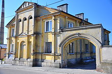
The May 1st Street, historic building

Evangelical church


Football stadium during tournament
Historic synagogue converted to small apartments


References[]
- ^ Alan Heath Synagogue at Dąbie
- ^ 'The Holocaust', Martin Gilbert, (1986), p.241.
- ^ Megargee, Geoffrey (2012). Encyclopedia of Camps and Ghettos. Bloomington, Indiana: University of Indiana Press. p. Volume II, 50-51. ISBN 978-0-253-35599-7.
| hide | ||
|---|---|---|
| Town and seat |  | |
| Villages | ||
| Authority control |
|
|---|
This Koło County location article is a stub. You can help Wikipedia by . |
- Cities and towns in Greater Poland Voivodeship
- Koło County
- Kalisz Governorate
- Poznań Voivodeship (1921–1939)
- Holocaust locations in Poland
- Koło County geography stubs