Dafni, Attica
Dafni
Δάφνη | |
|---|---|
 Dafni Location within Athens 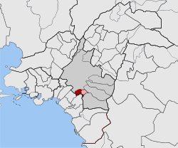 | |
| Coordinates: 37°57′N 23°44′E / 37.950°N 23.733°ECoordinates: 37°57′N 23°44′E / 37.950°N 23.733°E | |
| Country | Greece |
| Administrative region | Attica |
| Regional unit | Central Athens |
| Municipality | Dafni-Ymittos |
| • Municipal unit | 1.375 km2 (0.531 sq mi) |
| Elevation | 80 m (260 ft) |
| Population (2011)[1] | |
| • Municipal unit | 22,913 |
| • Municipal unit density | 17,000/km2 (43,000/sq mi) |
| Time zone | UTC+2 (EET) |
| • Summer (DST) | UTC+3 (EEST) |
| Postal code | 172 xx |
| Area code(s) | 210 |
| Website | www.dimosdafnis.gr[permanent dead link] |

Dafni (Greek: Δάφνη) is a suburb of Athens, Greece. Since the 2011 local government reform it is part of the municipality Dafni-Ymittos, of which it is the seat and a municipal unit.[2]
Geography[]
Dafni is an inner suburb of Athens, 2 km south of the Acropolis of Athens. Its built-up area is continuous with that of municipality of Athens and the surrounding suburbs Nea Smyrni, Agios Dimitrios and Ymittos. Dafni metro station is served by Line 2 of the Athens Metro. The main thoroughfare is Vouliagmenis Avenue, which connects Dafni with Athens city centre. At 1.375 km²[3] it is one of the smallest municipal units in the Athens metropolitan area.
Sports[]
The Amyntas Dafnis HEBA basketball club (A2 Division) competes at the Dafni Indoor Hall.

References[]
- ^ a b "Απογραφή Πληθυσμού - Κατοικιών 2011. ΜΟΝΙΜΟΣ Πληθυσμός" (in Greek). Hellenic Statistical Authority.
- ^ "ΦΕΚ B 1292/2010, Kallikratis reform municipalities" (in Greek). Government Gazette.
- ^ "Population & housing census 2001 (incl. area and average elevation)" (PDF) (in Greek). National Statistical Service of Greece. Archived from the original (PDF) on 2015-09-21.
External links[]
| Wikimedia Commons has media related to Dafni. |
- Official website[permanent dead link] (in Greek)
This Attica location article is a stub. You can help Wikipedia by . |
- Populated places in Central Athens (regional unit)
- Attica geography stubs