Dalat District
Dalat District | |
|---|---|
 The aerial view of Dalat town. The great river seen here is the Batang Oya. | |
 Districts of Sarawak | |
| Motto(s): Berakar Rumbia, Berinti Budaya[1] | |
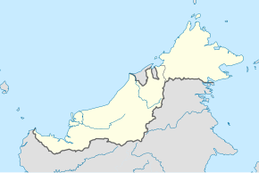 Dalat District Location of Dalat in Malaysian Borneo | |
| Coordinates: 2°44′20″N 111°56′19″E / 2.73889°N 111.93861°E | |
| District Office location | Dalat |
| Local area government | Majlis Daerah Dalat dan Mukah (MDDM) |
| Area | |
| • Total | 905.29 km2 (349.53 sq mi) |
| Population (2017[3]) | |
| • Total | 22,100 (projection) |
| District Officer | Kueh Lei Poh |
| Sub-district | Oya |
| Pekans | Dalat, Oya & Sungai Kut |
| Postcode | 96300 |


The Dalat District is located in Mukah Division, Sarawak, Malaysia. It is situated by the Oya river. The district covers areas from Kg. Penat to Oya, and from Muara Sg. Kut to Ulu Baoh.[2] The district has an area of 905.29 km2, while the Oya sub-district has an area of 147.47 km2.
History[]
Brief history of the district.[2]
- 2 April 1974 - Dalat was announced as a district, with Dalat town as the administrative centre. The district was under the Sibu Division and covers Oya, Dalat Proper, Nanga Baoh, Nanga Tamin, Stapang, Skim Sekuau and Nanga Pakoh. The district has 4 small towns, 23 villages and 115 longhouses.
- 1 March 2002 - Mukah was elevated to Mukah Division and Dalat district area was "revised" to area that covers Kg. Penat to Oya, and from Muara Sg. Kut to Ulu Baoh. There are 3 small towns, 23 villages and 22 longhouses in the district.
Demographics[]
According to the Department of Statistics Malaysia, Dalat has a population of 22,100. [3]
Economy[]
Main agricultural produce of the district is sago flour. 28,765 ha of agricultural land is used for sago plantation. 4 sago flour factories in the district are capable of producing 75 tonnes of sago flour per day.[5]
Languages[]
Most of the people use the Melanau language to communicate here. There is a slight difference of the language between each villages, yet they can understand each other very well. Other languages such as Malay, Sarawak Malay, Iban, Mandarin, Hokkien and English are also widely spoken.
Politics[]
Dalat is represented at the State Legislative Assembly by Datuk Hajah Fatimah Abdullah @ Ting Sai Ming, from Parti Pesaka Bumiputera Bersatu. She won the seat in the 18th State Election 2016 for the fourth time. For Parliament, Dalat is under Parliament 213: Mukah.
The current district officer is Kueh Lei Poh.
Education[]
There are two secondary schools in the district namely SMK Dalat (established in 1977) and SMK Oya (established in 2004). There are 25 primary schools which falls under the district jurisdiction.[6]
References[]
- ^ "Dalat waiting to be explored by culture, history buffs". The Borneo Post. Retrieved 2 August 2013.
- ^ a b c "Visi, Misi dan Latar Belakang". Pejabat Daerah Dalat. Retrieved 28 January 2011.
- ^ a b "Population Demography by Districts". Jabatan Perangkaan Malaysia. Retrieved 4 July 2018.
- ^ "Visi, Misi dan Latar Belakang" (in Malay). Pejabat Daerah Dalat. Archived from the original on 22 July 2011. Retrieved 2 August 2013.
- ^ "Mukah: Dari Taman Rumbia ke Kota Bestar". Pejabat Residen Mukah. Retrieved 12 September 2014.
- ^ "Daerah Dalat". Federation of Malaysian Consumers Associations. Archived from the original on 8 August 2016. Retrieved 7 June 2016.
External links[]
- Laman Web Rasmi Majlis Daerah Dalat & Mukah
- Laman Web Rasmi Pejabat Daerah Dalat
- Pictures of Dalat on Flickr
- Dalat Town Sharing Channel
- N.50 Dalat
- Notes on Dalat can be found in Robert Blust's collection in Kaipuleohone.
This Sarawak location article is a stub. You can help Wikipedia by . |
- Districts of Sarawak
- Sarawak geography stubs