Dalhart Municipal Airport
Dalhart Municipal Airport | |||||||||||||||
|---|---|---|---|---|---|---|---|---|---|---|---|---|---|---|---|
 1996 USGS Photo | |||||||||||||||
| Summary | |||||||||||||||
| Airport type | Public | ||||||||||||||
| Owner | City of Dalhart | ||||||||||||||
| Location | Hartley County, near Dalhart, Texas | ||||||||||||||
| Elevation AMSL | 3,991 ft / 1,216 m | ||||||||||||||
| Coordinates | 36°01′21″N 102°32′50″W / 36.02250°N 102.54722°WCoordinates: 36°01′21″N 102°32′50″W / 36.02250°N 102.54722°W | ||||||||||||||
| Map | |||||||||||||||
 KDHT | |||||||||||||||
| Runways | |||||||||||||||
| |||||||||||||||
| Statistics (2007) | |||||||||||||||
| |||||||||||||||

Dalhart Municipal Airport (IATA: DHT, ICAO: KDHT, FAA LID: DHT) is three miles (5 km) southwest of Dalhart, Texas,[1] a city straddling the border of Dallam and Hartley counties in the northwest corner of the Texas Panhandle.[2]
The airport sees no airlines.
Facilities[]
The airport covers 1,206 acres (488 ha) and has two asphalt runways: 3/21 is 5,669 x 75 ft (1,728 x 23 m) and 17/35 is 6,400 x 75 ft (1,951 x 23 m).[1]
In the year ending June 25, 2009 the airport had 22,750 aircraft operations, average 62 per day: 75% local general aviation, 25% transient general aviation, and <1% military. 30 aircraft are based at this airport: 80% single-engine, 17% multi-engine and 3% glider.[1]
History[]
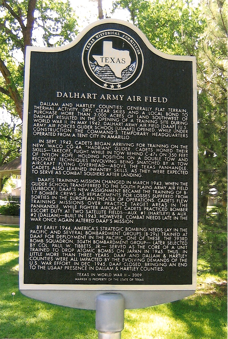
The airport was built by the Army and opened in May 1942 as Dalhart Army Airfield. Initially assigned to Army Air Forces Glider command, while under construction the command's temporary headquarters operated from a tent city in Amarillo.[3]
Dalhart AAF closed in December 1945; the property went to the city. Several remaining buildings have been used as the Dalhart municipal airport.[3]
References[]
- ^ Jump up to: a b c d FAA Airport Form 5010 for DHT PDF, effective 2010-11-18
- ^ "City of Dalhart, Texas". Archived from the original on 2007-10-10. Retrieved 2007-11-07.
- ^ Jump up to: a b Dalhart Army Airfield Historical Marker
External links[]
- Resources for this airport:
- FAA airport information for DHT
- AirNav airport information for KDHT
- ASN accident history for DHT
- FlightAware airport information and live flight tracker
- NOAA/NWS weather observations: current, past three days
- SkyVector aeronautical chart, Terminal Procedures
| hide Authority control | |
|---|---|
| General | |
| National libraries | |
This article about an airport in Texas is a stub. You can help Wikipedia by . |
This article about a building or structure in Texas is a stub. You can help Wikipedia by . |
- 1943 establishments in Texas
- Airports established in 1943
- Airports in Texas
- Buildings and structures in Hartley County, Texas
- Transportation in Hartley County, Texas
- Texas airport stubs
- Texas building and structure stubs