Dalton Highway
 | ||||
|---|---|---|---|---|
| James W. Dalton Highway North Slope Haul Road | ||||
Dalton Highway highlighted in red | ||||
| Route information | ||||
| Maintained by Alaska DOT&PF | ||||
| Length | 414 mi (666 km) | |||
| Existed | 1974–present | |||
| Major junctions | ||||
| South end | ||||
| North end | East Lake Colleen Drive in Deadhorse | |||
| Location | ||||
| Boroughs | Unorganized, North Slope | |||
| Highway system | ||||
| ||||


The James W. Dalton Highway, usually referred to as the Dalton Highway (and signed as Alaska Route 11), is a 414-mile (666 km)[1] road in Alaska. It begins at the Elliott Highway, north of Fairbanks, and ends at Deadhorse (an unincorporated community within the CDP of Prudhoe Bay) near the Arctic Ocean and the Prudhoe Bay Oil Fields. Once called the North Slope Haul Road (a name by which it is still sometimes known), it was built as a supply road to support the Trans-Alaska Pipeline System in 1974. It is named after James Dalton, a lifelong Alaskan and an engineer who supervised construction of the Distant Early Warning Line in Alaska and, as an expert in Arctic engineering, served as a consultant in early oil exploration in northern Alaska.[2] It is also the subject of the second episode of America's Toughest Jobs and the first episode of the BBC's World's Most Dangerous Roads.[3]
Route description[]
The highway, which directly parallels the pipeline, is one of the most isolated roads in the United States. There are only three towns along the route: Coldfoot (pop 10) at Mile 175,[4] Wiseman (pop 22) at Mile 188,[4] and Deadhorse (25 permanent residents, 3,500-5,000 or more seasonal residents depending on oil production) at the end of the highway at Mile 414.[4] Fuel is available at the E. L. Patton Yukon River Bridge (Mile 56), as well as Coldfoot and Deadhorse.[4] Two other settlements, Prospect Creek and Galbraith Lake, are uninhabited except for campers and other short-term residents.
The road itself is mostly gravel, very primitive in places, and small vehicle and motorcycle traffic carries significant risk. The nearest medical facilities are in Fairbanks and Deadhorse. Anyone embarking on a journey on the Dalton is encouraged to bring survival gear.
Despite its remoteness, the Dalton Highway carries a good amount of truck traffic through to Prudhoe Bay: about 160 trucks daily in the summer months and 250 trucks daily in the winter.[4] The highway comes to within a few miles of the Arctic Ocean. Beyond the highway's terminus at Deadhorse are private roads owned by oil companies, which are restricted to authorized vehicles only. There are, however, commercial tours that take people to the Arctic Ocean. All vehicles must take extreme precaution when driving on the road, and drive with headlights on at all times. There are quite a few steep grades (up to 12%) along the route, as well.
As of July 2013, 129 miles (208 km) of the highway are paved, in several sections, between the following mileages: 19 and 24; 37 and 50; 91 and 111; 113 and 197; 257 and 261; 344 and 352; and 356 and 361.
Truckers on the Dalton have given their own names to its various features, including: Taps, The Shelf, Franklin Bluffs, Oil Spill Hill, Beaver Slide, Surprise Rise, Sand Hill, Ice Cut, Gobbler's Knob, Finger Mountain, Oh Shit Corner,[5][6][7] and the Roller Coaster. The road reaches its highest elevation as it crosses the Brooks Range at Atigun Pass, 4,739 feet (1,444 m).
The highway is the featured road on the third, fourth, fifth and sixth seasons of the History reality television series Ice Road Truckers, which aired May 31, 2009 to present. It is also the subject of the second episode of America's Toughest Jobs and the first episode of the BBC's World's Most Dangerous Roads featuring Charley Boorman and Sue Perkins.[3] Polar bears are known to traverse the Arctic region of Alaska and can be seen wandering the outskirts of Deadhorse at the terminus of the Dalton Highway.
Google Street View has coverage of nearly the entire highway, which can now be seen on Google Maps (imaging stops at the security gate leading to the Prudhoe Bay oil field). It is one of the most northerly routes of Google street view in North America.
Recent flooding of the Sagavanirktok River, combined with melting of nearby ice roads under warmer climatic conditions have forced weeks-long closures of the road and the need for significant repairs, costing several million US dollars.[8][9][10][11]
Major intersections and other features[]
| Borough | Location | mi[12] | km | Destinations | Notes |
|---|---|---|---|---|---|
| Yukon-Koyukuk | Livengood | 0 | 0.0 | Southern terminus | |
| 21 | 34 | Overlook & Rest Area | [12] | ||
| Yukon River | 55 | 89 | E. L. Patton Yukon River Bridge | ||
| | 115 | 185 | Arctic Circle Wayside Rest Area | A short side road leads to viewing deck with interpretive displays[12] | |
| | 126 | 203 | Oh Shit Corner[5][6][7] | ||
| Prospect Creek | 135 | 217 | Access road to Prospect Creek Airport | Site of the lowest recorded temperature in the United States | |
| 150 | 240 | Wayside Rest Area | |||
| Coldfoot | 175 | 282 | Coldfoot Road | To Coldfoot Visitor Center | |
| 175 | 282 | Airport Road | To Coldfoot Airport and Coldfoot Post Office | ||
| Wiseman | 189 | 304 | Road to Wiseman | ||
| North Slope | | 248 | 399 | Continental Divide / Atigun Pass | The highest-altitude point on the road (elevation 4,739 ft / 1,422 m); Rivers to the south flow to the Pacific Ocean or Bering Sea and rivers north of here flow into the Arctic Ocean |
| Galbraith Lake | 275 | 443 | Galbraith Airport Road | To Galbraith Lake Airport | |
| Sag River | 348 | 560 | Sag River Overlook | ||
| Deadhorse | 414 | 666 | East Lake Colleen Drive | To Deadhorse Airport and Prudhoe Bay; Northern terminus | |
| 1.000 mi = 1.609 km; 1.000 km = 0.621 mi | |||||
Gallery[]

Dalton Highway south of the Continental Divide in the summer
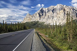
Dalton Highway passing Sukakpak Mountain in the summer
The Brooks Range south of the Continental Divide near Atigun Pass (6 March 2013)
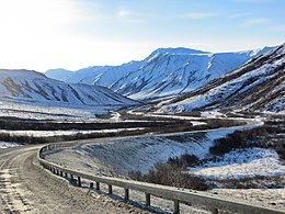
The Brooks Range north of the Continental Divide (Atigun Pass), mile 256

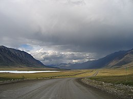
View of tundra in the summer from Dalton Highway, Northern Slope Borough, Alaska
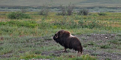
Muskox (Ovibos moschatus), Dalton Highway (Hwy 11) Northern Slope Borough, Alaska (10 August 2010)
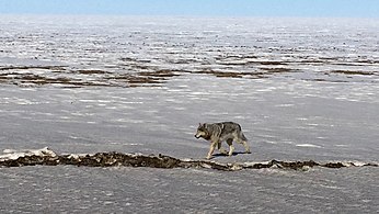
Wolf photographed from the Dalton Highway, Northern Slope Borough, Alaska (10 May 2016)
Aerial view of the highway with the Trans-Alaska Pipeline in the background (14 April 2015)

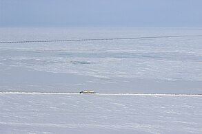
Highway about 10 miles south of Deadhourse, Northern Slope Borough, Alaska (5 April 2015)
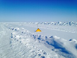
Highway sign in the snow, Northern Slope Borough, Alaska (17 April 2015)

Winter conditions on the Dalton Highway (April 2016)


See also[]
References[]
- ^ "Dalton Highway". United States Department of the Interior, Bureau of Land Management. Archived from the original on 2009-05-09. Retrieved 2009-09-04.
- ^ "The Dalton Highway Visitor Guide" (PDF). Bureau of Land Management. Summer 2009. Archived from the original (PDF) on 1 March 2012. Retrieved 6 December 2009.
- ^ Jump up to: a b "BBC Two — World's Most Dangerous Roads, Series 1, Alaska". Bbc.co.uk. 2012-07-07. Retrieved 2013-05-21.
- ^ Jump up to: a b c d e 2008 edition of The Milepost, pp. 517-529 (Morris Communications Company)
- ^ Jump up to: a b "Oh Shit Corner". 3 November 2010.
- ^ Jump up to: a b "Day 8 - The Dalton Highway". Alaskapade.com. June 26, 2011. Retrieved September 5, 2011.
- ^ Jump up to: a b Google (February 10, 2014). "Oh Shit Corner on Google Street View" (Map). Google Maps. Google. Retrieved February 10, 2014.
- ^ Wood, Rovin (May 18, 2015). "'Extreme' flooding again closes Dalton Highway". News Miner — the voice of interior Alaska. Retrieved 12 August 2016.
- ^ Bross, Dan (March 25, 2016). "Flooding still a large concern on Dalton Highway". Alaska Public Media. Fairbanks, AK. Retrieved 12 August 2016.
- ^ DOT&PF, Alaska (May 20, 2016). "Dalton Highway Update 5/20/2016: the road remains in good condition". Alaska Business Monthly. Retrieved 12 August 2016.
- ^ News, AD (August 11, 2016). "Feds give $2 million to repair Dalton Highway; state hopes to reopen in a week". Alaska Dispatch News. The Washington Post. Retrieved 12 August 2016.
- ^ Jump up to: a b c "The Dalton Highway: Visitor Guide" (PDF). U.S. Bureau of Land Management. Summer 2009. Archived from the original (PDF) on 2012-03-01. Retrieved 2009-12-06.
External links[]
| Wikimedia Commons has media related to Dalton Highway. |
Route map:

| ( • help)
|
| Wikivoyage has a travel guide for Dalton Highway. |
- BLM Alaska: Dalton Highway
- Bureau of Land Management 2011 Dalton Visitor Guide (24 pages)
- History Channel's "Ice Road Truckers" (Season Three)
| Authority control: National libraries |
|---|
- State highways in Alaska
- Transportation in North Slope Borough, Alaska
- Transportation in Unorganized Borough, Alaska
- Brooks Range
- Roads within the Arctic Circle