Danestown Fort
Ráth Bhaile an Dainigh | |
 | |
 Shown within Ireland | |
| Location | , County Meath, Ireland |
|---|---|
| Coordinates | 53°37′27″N 6°31′24″W / 53.624134°N 6.523275°WCoordinates: 53°37′27″N 6°31′24″W / 53.624134°N 6.523275°W |
| Type | Ringfort |
| Area | 1,661 square metres (0.410 acres) |
| Diameter | 46 metres (151 ft) |
| History | |
| Material | earth |
| Founded | AD 500–1000 |
| Periods | Middle Ages |
| Designation | National Monument |

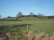
Danestown Fort is a ringfort (rath) and National Monument located in County Meath, Ireland.[1]
Location[]
Danestown ringfort is located about 700 metres (770 yd) southeast of Kentstown and on the south bank of the , a Boyne tributary.
Description[]
The inner raised circular platform is over 4 metres (13 ft) high with a deep fosse (ditch) and outer bank; the outer bank is over 2 metres (6.6 ft) high in places.[2]
References[]
- ^ "ME00500 - ROBERTSTOWN - Ringfort - rath". 6 December 2012.
- ^ [1]
Categories:
- Archaeological sites in County Meath
- National Monuments in County Meath