Daru Airport
Daru Airport | |||||||||||
|---|---|---|---|---|---|---|---|---|---|---|---|
 | |||||||||||
| Summary | |||||||||||
| Airport type | Public | ||||||||||
| Operator | Government | ||||||||||
| Serves | Daru, Western Province, Papua New Guinea | ||||||||||
| Elevation AMSL | 6 m / 20 ft | ||||||||||
| Coordinates | 09°05′12″S 143°12′28″E / 9.08667°S 143.20778°ECoordinates: 09°05′12″S 143°12′28″E / 9.08667°S 143.20778°E | ||||||||||
| Map | |||||||||||
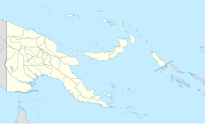 DAU Location of the airport in Papua New Guinea | |||||||||||
| Runways | |||||||||||
| |||||||||||

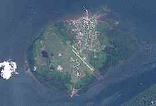
Daru Airport (IATA: DAU, ICAO: AYDU) is an airport serving Daru, the capital of the Western Province in Papua New Guinea.
The airfield was constructed before or during World War II. During the war it was used as a refuelling stop by Allied fighter aircraft. The Australian Army rebuilt the airport in 1965.[4]
Airlines and destinations[]
| Airlines | Destinations |
|---|---|
| Air Niugini | Port Moresby |
| PNG Air | Awaba, Balimo, Kiunga, Port Moresby, Sasereme, Suki |
References[]
- ^ Airport information for AYDU at World Aero Data. Data current as of October 2006.Source: DAFIF.
- ^ Airport information for DAU at Great Circle Mapper. Source: DAFIF (effective October 2006).
- ^ Airport information for Daru Airport at Transport Search website.
- ^ "Daru Airfield Western Province (Fly) Papua New Guinea (PNG)". Pacific Wrecks. Retrieved 5 February 2021.
External links[]
This article about an Oceanian airport is a stub. You can help Wikipedia by . |
This article about a Papua New Guinean building or structure related topic is a stub. You can help Wikipedia by . |
Categories:
- Airports in Papua New Guinea
- Western Province (Papua New Guinea)
- Oceanian airport stubs
- Papua New Guinean building and structure stubs