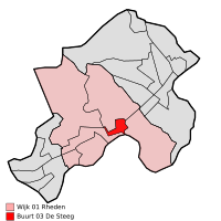
De Steeg
De Steeg | |
|---|---|
 | |
| Coordinates: 52°01′N 6°04′E / 52.017°N 6.067°ECoordinates: 52°01′N 6°04′E / 52.017°N 6.067°E | |
| Country | Netherlands |
| Province | Gelderland |
| Municipality | Rheden |
| Population (1 January 2013) | circa 1,122 |

De Steeg is a Dutch village within the municipality of Rheden. It has an area of 0.77 km²[1] and a population of 1,122 (2013)[2] Due to its central location within the municipality, it houses the town hall.
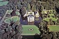
Middachten Castle is located near the village. Several De Steeg buildings once belonged to the Middachten estate. These buildings, including the Post office in De Steeg, can be recognized by the red and white color scheme.
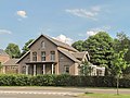
Gallery[]

Catholic church
Former town hall
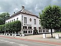
Monumental hotel building at the Hoofdstraat

Huize Rhederpark

Monumental building at the Oversteeg 14
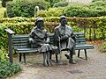
Statue Simon Carmiggelt and his wife Tiny


References[]
- ^ "Archived copy". Archived from the original on 2006-07-24. Retrieved 2006-07-24.CS1 maint: archived copy as title (link) Statistics on statline.cbs.nl
- ^ [1] Archived 2013-12-15 at the Wayback Machine Statistics on Rheden.nl
| hide Authority control | |
|---|---|
| General |
|
| National libraries | |
Categories:
- Populated places in Gelderland
- Rheden