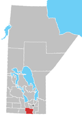
Deerwood, Manitoba
Deerwood | |
|---|---|
 Monument Commemorating Deerwood School District Number 926 | |
 Deerwood Location of Deerwood in Manitoba | |
| Coordinates: 49°23′52″N 98°23′11″W / 49.39778°N 98.38639°WCoordinates: 49°23′52″N 98°23′11″W / 49.39778°N 98.38639°W | |
| Country | |
| Province | |
| Region | Pembina Valley |
| Census Division | No. 3 |
| Government | |
| • Governing Body | Rural Municipality of Thompson Council |
| • MP | Candice Bergen |
| • MLA | Blaine Pedersen |
| Time zone | UTC−6 (CST) |
| • Summer (DST) | UTC−5 (CDT) |
| Area code(s) | 204 |
| NTS Map | 062G08 |
| GNBC Code | GAGJL |
Deerwood is a locality in south central Manitoba, Canada. It is located approximately 31 kilometers (19 miles) northwest of Morden, Manitoba[2] in the Rural Municipality of Thompson.
The Post Office was established on 2-21-5W in 1895 and closed in 1968. It was a railway point on the Northern Pacific Railway and was named by a railway official for the number of deer in a heavily wooded area while railway construction was taking place. It was also a School District from 1908 to 1951.
Climate[]
According to the Köppen Climate Classification system, Deerwood has a humid continental climate, abbreviated "Dfb" on climate maps.[3]
References[]
- ^ "Population and dwelling counts, for Canada and census subdivisions (municipalities), 2006 and 2001 censuses - 100% data". Statistics Canada, 2006 Census of Population. 2008-11-05. Retrieved 2009-01-30.
- ^ "Querying Canadian Geographical Names". Archived from the original on 2013-12-27. Retrieved 2012-09-05.
- ^ Climate Summary for Deerwood, Manitoba
- Geographic Names of Manitoba (pg. 62) - Deerwood - the Millennium Bureau of Canada
Categories:
- Localities in Manitoba

