Deißlingen
Deißlingen | |
|---|---|
 The Deißlinger Hagenstall | |
 Coat of arms | |
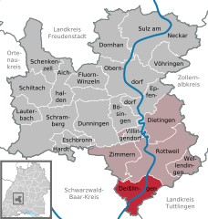
show Location of Deißlingen within Rottweil district | |
 Deißlingen | |
| Coordinates: 48°06′48″N 08°36′22″E / 48.11333°N 8.60611°ECoordinates: 48°06′48″N 08°36′22″E / 48.11333°N 8.60611°E | |
| Country | Germany |
| State | Baden-Württemberg |
| Admin. region | Freiburg |
| District | Rottweil |
| Area | |
| • Total | 32.16 km2 (12.42 sq mi) |
| Elevation | 611 m (2,005 ft) |
| Population (2020-12-31)[1] | |
| • Total | 6,235 |
| • Density | 190/km2 (500/sq mi) |
| Time zone | UTC+01:00 (CET) |
| • Summer (DST) | UTC+02:00 (CEST) |
| Postal codes | 78652 |
| Dialling codes | 07420 |
| Vehicle registration | RW |
| Website | www |


Deißlingen is a municipality of the district of Rottweil of Baden-Württemberg, Germany.
History[]
In 1802-03, Deißlingen, a possession of the Free Imperial City of Rottweil, and Lauffen ob Rottweil, a property of Rottenmünster Abbey, were mediatized to the Electorate, later Kingdom, of Württemberg. Deißlingen was assigned to a newly organized Oberamt , and Lauffen to . Lauffen joined Deißlingen in Rottweil's jurisdiction on 27 October 1810. The district was reorganized on 1 October 1938 as Landkreis Rottweil, to which the two towns were still assigned. On 1 January 1974, Lauffen was incorporated into Deißlingen and a new municipality formed.[2]
Geography[]
The municipality (Gemeinde) of Deißlingen covers 32.15 square kilometers (12.41 sq mi) of the Rottweil district of Baden-Württemberg, which assigns Deißlingen to the metropolitan area of Villingen-Schwenningen, Tuttlingen, and Rottweil. Deißlingen is physically located in a transitional landscape between the muschelkalk-keuper plateaus of the to the north, the Swabian Jura to the east, and the Baar to the south. Elevation above sea level in the municipal area ranges from a high of 753 meters (2,470 ft) Normalnull (NN) at the border with Tuttlingen district to a low of 574 meters (1,883 ft) NN on the Neckar as it forms the border with Rottweil.[2]
The forested slopes of the Neckar and Mückenbach river valleys were declared in 1953. They were joined in 1990 by the .[2]
Politics[]
Deißlingen has two boroughs (Ortsteile): Deißlingen and Lauffen.[2]
Coat of arms[]
The municipal coat of arms for Deißlingen shows a blue wolfsangel upon a field of yellow, with a black bar at the top containing a yellow stag antler, a clear reference to Württemberg. The wall anchor is a motif associated with Lauffen ob Rottweil's as early as 1780. This coat of arms is a combination of those of the towns of Deißlingen and Lauffen, with a change made to the chief to comply with the rule of tincture. The Rottweil district office approved the official use of the coat of arms and issued a corresponding municipal flag on 10 December 1981.[2]
References[]
- ^ "Bevölkerung nach Nationalität und Geschlecht am 31. Dezember 2020". Statistisches Landesamt Baden-Württemberg (in German). June 2021.
- ^ Jump up to: a b c d e "Deißlingen". LEO-BW (in German). Baden-Württemberg. Retrieved 24 July 2020.
External links[]
- Official website
 (in German)
| show Towns and municipalities in Rottweil (district) |
|---|
| Authority control |
|---|
- Municipalities in Baden-Württemberg
- Rottweil (district)