Demeljoch
This article does not cite any sources. (February 2016) |
| Demeljoch | |
|---|---|
 Demeljoch from the North (from left to right: Zotenjoch, Demeljoch, and Dürrnbergjoch) | |
| Highest point | |
| Elevation | 1,924 m (6,312 ft) |
| Isolation | 2.8 km (1.7 mi) |
| Geography | |
| Location | Bavaria, Germany and Tyrol, Austria |
The Demeljoch (1,924 m) is a mountain at the border between Bavaria, Germany, and Tyrol, Austria. The summit can be reached through a hiking trail starting near the easternmost point of the Sylvensteinsee.

Boundary marker on the Demeljoch, at the border between Austria and Germany. The "Ö" stands for "Österreich", i.e. Austria in German.

Same boundary marker on the other side. The "D" stands for "Deutschland", i.e. Germany in German.
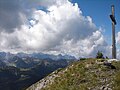
Summit cross on the Demeljoch, with, in the background, the view towards the west.
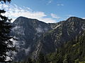
Demeljoch (left) and Dürnbergjoch (right) from the north.


Coordinates: 47°33′N 11°35′E / 47.550°N 11.583°E

This Bavaria location article is a stub. You can help Wikipedia by . |
This Tyrol location article is a stub. You can help Wikipedia by . |
- Mountains of Bavaria
- Mountains of Tyrol (state)
- Mountains of the Alps
- Bavaria geography stubs
- Tyrol geography stubs