Denudation
This article may require copy editing for grammar, style, cohesion, tone, or spelling. (August 2021) |
In geology, denudation involves the processes that cause the wearing away of Earth's surface by moving water, by ice, by wind, and by waves, leading to a reduction in elevation and in relief of landforms and of landscapes. Although the terms have been used interchangeably, erosion is the transport of soil and rocks from one location to another,[1] and denudation is the sum of processes that result in the lowering of Earth's surface, including erosion.[2] Endogenous processes such as volcanoes, earthquakes, and tectonic uplift and expose continental crust to the exogenous processes of weathering, of erosion, and of mass wasting. The effects of denudation have been recorded for millennia; however, the mechanics behind it have been debated for the past 200 years[when?] and have only begun to be understood in the past few decades.[3][when?]
Processes[]
Denudation incorporates the mechanical, biological and chemical processes of erosion, weathering and mass wasting. Denudation can involve the removal of both solid particles and dissolved material. These include sub-processes of cryofracture, insolation weathering, slaking, salt weathering, bioturbation and anthropogenic impacts.[4]
Factors affecting denudation include:
- Anthropogenic (human) activity including agriculture, damming, mining, and deforestation.[5]
- Biosphere via animals, plants, and microorganisms contributing to chemical and physical weathering.[6]
- Climate while most directly through chemical weathering from rain, climate also dictates what kind of weathering occurs.[7]
- Lithology, or the type of rock plays an important role in denudation.
- Surface topography and changes to surface topography such as mass wasting and erosion.[8]
- Tectonic activity such as deformation, the changing of rocks due to stress mainly from tectonic forces,[8] and orogeny, the processes that form mountains.
Rates[]
Denudation is measured in the wearing down of Earth's surface in inches or centimeters per 1000 years.[9] This rate is intended as an estimate and often assumes uniform erosion, among other things, to simplify calculations. Assumptions made are often only valid for the landscapes being studied. Measurements of denudation done over large areas are done by averaging the rates of subdivisions. Often, no adjustments are made for human impact, which causes the measurements to be inflated.[10][ambiguous] Calculations have suggested that soil loss of up to 0.5 m caused by human activity will change previously calculated denudation rates by less than 30%.[11]
Denudation rates are usually much lower than the rates of uplift, and average orogeny rates can be eight times the maximum average denudation.[12] The only areas at which there could be equal rates of denudation and uplift are active plate margins with an extended period of continuous deformation.[13]
Denudation is measured in catchment-scale measurements and can use other erosion measurements, generally split into dating and survey methods. Techniques for measuring erosion and denudation include stream load measurement, cosmogenic exposure and burial dating, erosion tracking, topographic measurements, surveying the deposition in reservoirs, landslide mapping, chemical fingerprinting, thermochronology, and analysis of sedimentary records in deposition areas.[14] The most common way of measuring denudation is from stream load measurements taken at gauging stations.[9] The suspended load, bed load, and dissolved load are included in measurements. The weight of the load is converted to volumetric units and the load volume is divided by the area of the watershed above the gauging station.[9] An issue with this method of measurement is the high variation in fluvial erosion from year to year, which can be as high as a factor of five between successive years.[15] An important equation for denudation is the stream power law: , where E is erosion rate, K is the erodibility constant, A is drainage area, S is channel gradient, and m and n are functions which are usually given beforehand or assumed based on the location.[8] The majority of denudation measurements are done based on stream load measurements and analysis of the sediment or the water chemistry.

A more recent technique is cosmogenic isotope analysis, used in conjunction with stream load measurements and sediment analysis. This measures chemical weathering intensity by calculating chemical alteration in molecular proportions.[11] Preliminary research into using cosmogenic isotopes to measure weathering were done by studying the weathering of feldspar and volcanic glass, as they contain most of the material found in the upper crust. The most common isotopes used are 26Al and 10Be; however, 10Be is used more often in these analysis. 10Be is used due to its abundance and while it is not stable, its half-life of 1.39 million years is relatively stable compared to the thousand or million-year scale that denudation is measured in. 26Al is used because of the low presence of Al in quartz, making it easy to separate, and because there is no risk of contamination of atmospheric 10Be.[16] This technique was developed because previous denudation-rate studies have assumed steady rates of erosion even though such uniformity is difficult to verify in the field and may be invalid for many landscapes, and its use to help measure denudation and geologically date events was recognized.[17] On average, the concentration of undisturbed cosmogenic isotopes in sediment leaving a particular basin is inversely related to the rate at which that basin is eroding. This means in a rapidly-eroding basin, most rock will be exposed to only a small number of cosmic rays before erosion and transport out of the basin; as a result, isotope concentration will be low. In a slowly-eroding basin, integrated cosmic ray exposure is much greater and, consequently, isotope concentration will be much higher.[11] An issue with this technique is that it is difficult to measure isotopic reservoirs in most areas, so uniform erosion is assumed. There is also variation in year-to-year measurements, which can be as high as a factor of three.[18]
There are multiple issues when measuring denudation, including issues both with the technology used and with the environment.[14] Landslides can interfere with denudation measurements in mountainous regions, especially the Himalayas.[19] Dating methods have two primary issues, one being uncertainties in the measurements, both with equipment used and with assumptions made during measurement; the other is errors from the relationship between the measured ages and histories of the markers.[14] This relates to the issue of making assumptions based on the measurements being made, and the area being measured. Environmental factors such as temperature, atmospheric pressure, humidity, elevation, wind, the speed of light at higher elevations if using lasers or time of flight measurements, instrument drift,[14] chemical erosion, and for cosmogenic isotopes climate and snow or glacier coverage have an impact.[19] Additionally, when studying denudation the Stadler effect, which states that measurements over shorter time periods show higher accumulation rates, and measurements over longer time periods show lower accumulation rates should be considered.[20] In a study by James Gilully the presented data suggested that the denudation rate has stayed roughly the same throughout the Cenozoic era based on geological evidence;[21] however, given estimates of denudation rates at the time and the United States' elevation, it would take 11-12 million years to erode North America,[15] well before the 66 million years of the Cenozoic.[22]
The research on denudation is primarily in river basins and in mountainous regions like the Himalayas due to them being very geologically-active regions,[23] which allows for research between uplift and denudation. There is also research on the effects of denudation on karst, as only about 30% of chemical weathering from water occurs on the surface.[24] Denudation has a large impact on karst and landscape evolution, as the most rapid changes to landscapes occur when there are changes to subterranean structures.[24] Other research includes what affects denudation rates, and this research is mostly studying how climate[25] and vegetation[26] impact denudation. There is also research being done to find the relation between denudation and isostasy, since the more denudation occurs, the lighter the crust becomes in an area, which allows for uplift.[27] The work is primarily trying to determine a ratio between denudation and uplift, so better estimates can be made in the future on changes in the landscape. In 2016 and 2019, research was conducted which attempted to apply denudation rates to improve the stream power law so that it can be used more effectively.[28][29]
Proposed processes[]

The effects of denudation have been written about since antiquity, although the terms denudation and erosion have been used interchangeably throughout most of history.[3] It was not until the Age of Enlightenment that scholars began trying to understand how erosion and denudation occurred without mythical or biblical explanations. Throughout the 18th century scientists theorized that valleys are formed by streams running through them, not from floods or other cataclysms.[30] In 1785 a Scottish physician named James Hutton proposed an Earth history based on observable processes over an unlimited amount of time,[31] which marked a shift from assumptions based on faith to reasoning based on logic and observation. In 1802 John Playfair, a friend of Hutton, published a paper clarifying Hutton's ideas and explained the basic process of how water wears down the surface and described erosion and chemical weathering.[32] Between 1830 and 1833 Charles Lyell published three volumes of Principles of Geology which described how the surface of Earth is shaped by ongoing processes and that endorsed and established gradual denudation in the wider scientific community.[33]

As denudation came into the wider conscience, questions began to arise of how denudation occurred and what the result was. As for the result of denudation, Hutton and Playfair suggested that over a period of time the landscape would eventually be worn down to erosional planes at or near sea level which gave the theory the name planation.[30] Charles Lyell proposed that marine planation, or oceans and ancient shallow seas, were the primary driving force behind denudation. While surprising given the centuries of observation of fluvial and pluvial erosion, this is more understandable given that early geomorphology was largely developed in Britain, where the effects of coastal erosion are more evident and plays a larger role in geomorphic processes.[30] There was more evidence against marine planation than there was for it. By the 1860s marine planation had largely fell from favor, led by Andrew Ramsay, a former proponent of marine planation, recognizing that rain and rivers play a more important role in denudation. In North America during the mid-19th century, there were advancements made in identifying fluvial, pluvial, and glacial erosion. The work being done in the Appalachians and American West that formed the basis for W.M. Davis to hypothesize peneplanation, despite that while peneplanation was compatible in the Appalachians, it did not work as well in the more active American West. Peneplanation was a cycle where young landscapes were produced by uplift and were denudated down to sea level, which is the base level. The process would be restarted when the old landscape was uplifted again or when the base level was lowered, producing a new young landscape.[34] Publication of the Davisian cycle of erosion caused many geologists to begin looking for evidence of planation around the world. Unsatisfied with Davis's cycle due to evidence from the Western United States, Grove Karl Gilbert suggested that backwearing of slopes would shape landscapes into pediplains,[35] and W.J. McGee named these landscapes pediments. This later giving the concept the name pediplanation when L.C. King applied it to a global scale.[36] The dominance of the Davisian cycle gave rise to several theories to explain planation such as eolation and glacial planation, although only etchplanation survived time and scrutiny as it was based on observations and measurements done in different climates around the world, and it explained irregularities in landscapes.[37] The majority of these concepts failed, one reason being that Joseph Jukes, a popular geologist and professor, separated denudation and uplift in an 1862 publication which had a lasting impact on geomorphology.[38] Other major reasons are that the cycles, Davis's in particular, were generalizations based on broad observations of the landscape and not detailed measurements, a lot of the concepts were developed based on local or specific processes, not regional processes, and they assumed long periods of continental stability.[30]
While the Davisian Cycle was the main influential theory in geomorphology, there were opponents. Grove Karl Gilbert was one, who over time based on measurements realized that denudation was nonlinear and started developing explanations based on fluid dynamics and equilibrium concepts. Another was Walther Penck, who came up with a more complex theory that stated that denudation and uplift occurred at the same time and landscape formation occurred based on the ratio between denudation and uplift rates and proposed that geomorphology was based on endogenous and exogenous processes.[39] Penck's theory, while ultimately coming to be ignored, did return to denudation and uplift occurring simultaneously and relied on continental mobility, even though Penck rejected continental drift. The Davisian and Pecnkian models were heavily debated for a few decades until Penck's was ignored, and support waned for Davis' cycle after his death as more critiques were made. One critic was John Leighly, who stated that geologists did not know how landforms were developed, so Davis's theory was ultimately built upon a shaky foundation.[40] From 1945 to 1965 there was a change in geomorphology research that saw a shift from mostly deductive work to detailed experimental designs, improved technologies, and techniques, although this led to research over details of established theories, rather than researching new theories. Through the 1950s and 1960s, as improvements were made in ocean geology and geophysics, it became more and more clear that Wegener's theory on continental drift was correct and that there is constant movement of parts (the plates) of Earth's surface. There were also improvements made in geomorphology to quantify slope forms and drainage networks, and to find relations between the form and process and the magnitude and frequency of geomorphic processes.[30] The final blow to peneplanation came in 1964 when a team led by Luna Leopold published Fluvial Processes in Geomorphology by linking landforms to measurable precipitation-infiltration runoff processes and concluded that no peneplains exist over large areas in modern times, and any historical peneplains would have to be proven to exist, rather than inferred from modern geology. They also stated that pediments could form across all rock types and regions, although through different processes.[41] Through these findings and improvements in geophysics, the study of denudation shifted from planation to studying what relationships affect denudation, including uplift, isostasy, lithology, and vegetation, and measuring denudation rates around the world.[30]
Examples[]

B) Chachahén Volcano, Mendoza Province, Argentina, a volcano with strong effect of erosion but no denudation
C) Cardiel Lake, Santa Cruz Province, Argentina, a volcanic area under strong effect of denudation, exposing subvolcanic rock body.[42]
Denudation exposes deep subvolcanic structures on the present surface of the area where volcanic activity once occurred. Sub-volcanic structures such as volcanic plugs and dikes are exposed by denudation.

A mountain road in Ladhk that shows signs of mass wasting and erosion that result in bedrock exposure.
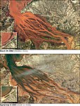
Satellite images that show the extreme erosion in the Betsiboka Estuary in Madagascar due to deforestation, which results in rapid denudation and one of the fastest changing coastlines.[43]

Cliffs of a coastline in Portugal that have denudated due to erosion and weathering primarily from water and salt.


Other examples include:
- Earthquakes causing landslides.
- Haloclasty, the build-up of salt in cracks in rocks leading to erosion and weathering.[4]
- Ice accumulating in the cracks of rocks.
- Microorganisms contributing to weathering through cellular respiration.
References[]
- ^ "Erosion". Encyclopedia Britannica.
- ^ Dixon, John C.; Thorn, Colin E. (2005). "Chemical weathering and landscape development in mid-latitude alpine environments". Geomorphology. 67 (1–2): 127–145. Bibcode:2005Geomo..67..127D. doi:10.1016/j.geomorph.2004.07.009. ISSN 0169-555X.
- ^ Jump up to: a b Shukla, Dericks Praise (2017-10-18), "Introductory Chapter: Geomorphology", Hydro-Geomorphology - Models and Trends, InTech, doi:10.5772/intechopen.70823, ISBN 978-953-51-3573-9
- ^ Jump up to: a b Smithson, P et al (2008) Fundamentals of the Physical Environment (4th ed.)
- ^ Kemp, David B.; Sadler, Peter M.; Vanacker, Veerle (2020-11-26). "The human impact on North American erosion, sediment transfer, and storage in a geologic context". Nature Communications. 11 (1): 6012. doi:10.1038/s41467-020-19744-3. ISSN 2041-1723. PMC 7691505. PMID 33243971.
- ^ Blatt H, Middleton G, Murray R (1980). Origin of sedimentary rocks 2e. pp. 245–250.
- ^ "Weathering and Landforms 5.1". www.radford.edu. Retrieved 2021-04-16.
- ^ Jump up to: a b c K., Lutgens, Frederick (2018). Essentials of geology. ISBN 978-0-13-444662-2. OCLC 958585873.
- ^ Jump up to: a b c Ritter, D.F. 1967. Rates of denudation. Jour. Geol. Educ. 15, C.E.G.S. short rev. 6:154-59
- ^ Judson, S. 1968. Erosion of the land. Am. Scientist 56:356-74
- ^ Jump up to: a b c BIERMAN, PAUL; STEIG, ERIC J. (February 1996). <125::aid-esp511>3.0.co;2-8 "Estimating Rates of Denudation Using Cosmogenic Isotope Abundances in Sediment". Earth Surface Processes and Landforms. 21 (2): 125–139. Bibcode:1996ESPL...21..125B. doi:10.1002/(sici)1096-9837(199602)21:2<125::aid-esp511>3.0.co;2-8. ISSN 0197-9337.
- ^ Schumm, Stanley Alfred (1963). "The disparity between present rates of denudation and orogeny". Shorter Contributions to General Geology. doi:10.3133/pp454h. ISSN 2330-7102.
- ^ Burbank, D.W., and Beck, R.A. 1991. Rapid long-term rates of denudation. Geology 19:1169-72
- ^ Jump up to: a b c d Turowski, Jens M.; Cook, Kristen L. (2016-08-31). "Field techniques for measuring bedrock erosion and denudation". Earth Surface Processes and Landforms. 42 (1): 109–127. doi:10.1002/esp.4007. ISSN 0197-9337.
- ^ Jump up to: a b Judson, Sheldon; Ritter, Dale F. (1964-08-15). "Rates of regional denudation in the United States". Journal of Geophysical Research. 69 (16): 3395–3401. Bibcode:1964JGR....69.3395J. doi:10.1029/jz069i016p03395. ISSN 0148-0227.
- ^ Nishiizumi, K.; Lal, D.; Klein, J.; Middleton, R.; Arnold, J. R. (January 1986). "Production of 10Be and 26Al by cosmic rays in terrestrial quartz in situ and implications for erosion rates". Nature. 319 (6049): 134–136. Bibcode:1986Natur.319..134N. doi:10.1038/319134a0. ISSN 0028-0836. S2CID 4335625.
- ^ Kohl, C.P; Nishiizumi, K (September 1992). "Chemical isolation of quartz for measurement of in-situ -produced cosmogenic nuclides". Geochimica et Cosmochimica Acta. 56 (9): 3583–3587. Bibcode:1992GeCoA..56.3583K. doi:10.1016/0016-7037(92)90401-4. ISSN 0016-7037.
- ^ Lupker, Maarten; et al. (2012). "10Be-derived Himalayan denudation rates and sediment budgets in the Ganga basin". Earth and Planetary Science Letters. 334: 146. Bibcode:2012E&PSL.333..146L. doi:10.1016/j.epsl.2012.04.020.
- ^ Jump up to: a b Ojha, Lujendra; Ferrier, Ken L.; Ojha, Tank (2019-02-26). "Millennial-scale denudation rates in the Himalaya of Far Western Nepal". doi:10.5194/esurf-2019-7. Cite journal requires
|journal=(help) - ^ Sadler, Peter M. (September 1981). "Sediment Accumulation Rates and the Completeness of Stratigraphic Sections". The Journal of Geology. 89 (5): 569–584. Bibcode:1981JG.....89..569S. doi:10.1086/628623. ISSN 0022-1376. S2CID 140202963.
- ^ Gilluly, James (1955-05-01). "Review". Pacific Historical Review. 24 (2): 187–189. doi:10.2307/3634584. ISSN 0030-8684. JSTOR 3634584.
- ^ "Cenozoic". www.usgs.gov. Retrieved 2021-04-19.
- ^ "The Himalayas [This Dynamic Earth, USGS]". pubs.usgs.gov. Retrieved 2021-04-26.
- ^ Jump up to: a b Gabrovšek, Franci (2008). "On concepts and methods for the estimation of dissolutional denudation rates in karst areas". Geomorphology. 106 (1–2): 9–14. doi:10.1016/j.geomorph.2008.09.008.
- ^ Wasak-Sęk, Katarzyna (2021). "Buffering role of soil in chemical denudation in mountainous areas affected by windfall events – In light of experimental research". Geomorphology. 381: 107642. Bibcode:2021Geomo.38107642W. doi:10.1016/j.geomorph.2021.107642. S2CID 234056976.
- ^ Torres Acosta, Veronica; Schildgen, Taylor; Clarke, Brian; Scherler, Dirk; Bookhagen, Bodo; Wittmann, Hella; von Blankenburg, Friedhelm; Strecker, Manfred (2014-05-01). "Effects of vegetation cover on landscape denudation rates". EGU General Assembly 2014, held 27 April - 2 May 2014 in Vienna, Austria. p. 8857. Bibcode:2014EGUGA..16.8857T. 8857.
- ^ Gilchrist, A.R. (1990). "Differential denudation and flexural isostasy in formation of rifted-margin upwarps". Nature. 346 (6286): 739–742. Bibcode:1990Natur.346..739G. doi:10.1038/346739a0. S2CID 42743054.
- ^ Harel, M.-A. (2016). "Global analysis of the stream power law parameters based on worldwide 10Be denudation rates" (PDF). Geomorphology. 268: 184. Bibcode:2016Geomo.268..184H. doi:10.1016/j.geomorph.2016.05.035. hdl:20.500.11820/a17cd979-3d06-461c-9f14-4a6afa545c10.
- ^ Yuan, X. P.; Braun, J.; Guerit, L.; Rouby, D.; Cordonnier, G. (2019). "A New Efficient Method to Solve the Stream Power Law Model Taking Into Account Sediment Deposition". Journal of Geophysical Research: Earth Surface. 124 (6): 1346–1365. Bibcode:2019JGRF..124.1346Y. doi:10.1029/2018JF004867. ISSN 2169-9011.
- ^ Jump up to: a b c d e f Orme, A.R. (2013). "1.12 Denudation, Planation, and Cyclicity: Myths, Models, and Reality". Treatise on Geomorphology. 1: 205–232. doi:10.1016/B978-0-12-374739-6.00012-9. ISBN 9780080885223.
- ^ Hutton, James Geologe (1997). Theory of the Earth with proofs and illustrations: in four parts. The Geological Society. OCLC 889722081.
- ^ Playfair, John (2009). Illustrations of the Huttonian Theory of the Earth. Cambridge: Cambridge University Press. doi:10.1017/cbo9780511973086. ISBN 978-0-511-97308-6.
- ^ Lyell, Charles (1830–1833). Principles of Geology: Being an Attempt to Explain the Former Changes of the Earth's Surface, By Reference to Causes Now in Operation. John Murray.
- ^ Davis, William M. (November 1899). "The Geographical Cycle". The Geographical Journal. 14 (5): 481–504. doi:10.2307/1774538. ISSN 0016-7398. JSTOR 1774538.
- ^ Gilbert, G.K. (1877). "Report on the geology of the Henry Mountains". Monograph. p. 212. doi:10.3133/70039916.
- ^ Charles., King, Lester (1967). The morphology of the earth: a study and synthesis of world scenery. Oliver & Boyd. OCLC 421411.
- ^ Wayland, E.J. (1934). "Rifts, Rivers, Rains and Early Man in Uganda". The Journal of the Royal Anthropological Institute of Great Britain and Ireland. 64: 333–352. doi:10.2307/2843813. JSTOR 2843813.
- ^ Jukes, J. B. (1862-02-01). "On the Mode of Formation of some of the River-valleys in the South of Ireland". Quarterly Journal of the Geological Society. 18 (1–2): 378–403. doi:10.1144/gsl.jgs.1862.018.01-02.53. hdl:2027/uiug.30112068306734. ISSN 0370-291X. S2CID 130701405.
- ^ Oldroyd, D.R. "1.5 Geomorphology in the First Half of the Twentieth Century". Treatise on Geomorphology.
- ^ Leighly, John. "Symposium: Walther Penck's Contribution to Geomorphology: [Introduction]". Annals of the Association of American Geographers.
- ^ Leopold, Luna B. (1964). Fluvial Processes in Geomorphology. ISBN 978-0-486-84552-4. OCLC 1137178795.
- ^ Motoki, Akihisa; Sichel, Susanna. Avaliação de aspectos texturais e estruturais de corpos vulcânicos e subvulcânicos e sua relação com oambiente de cristalização, com base em exemplos do Brasil, Argentina e Chile (PDF) (in Portuguese).
- ^ "Betsiboka Estuary, Madagascar". earthobservatory.nasa.gov. 2004-04-12. Retrieved 2021-04-22.
| hide Authority control | |
|---|---|
| General | |
| National libraries | |
| Other | |
- Geomorphology
- Geological processes