Derwent Edge
| Derwent Edge | |
|---|---|
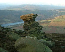 The Salt Cellar with Ladybower Reservoir in the Background | |
| Highest point | |
| Elevation | 538 m (1,765 ft)(Back Tor)[1] |
| Prominence | 67 m (220 ft)[1] |
| Listing | TuMP |
| Coordinates | 53°24′55″N 1°42′15″W / 53.4152°N 1.7041°W (Back Tor) |
| Geography | |
| Location | Derbyshire, England |
| Parent range | Kinder Scout[1] |
| OS grid | SK197909 |
| Topo map | OS Landranger 110 |

Derwent Edge is a Millstone Grit escarpment that lies above the Upper Derwent Valley in the Peak District National Park in the English county of Derbyshire. An Ordnance Survey column marks the highest point of the Edge at Back Tor (538 metres, 1765 feet).[1] North of Back Tor the edge extends into Howden Edge and enters the county of South Yorkshire.
Geography and geology[]
The Millstone Grit forms the edge of the high peat moorland plateau on the eastern side of the valley above Ladybower Reservoir, the edges being the last remains of the gritstone which originally covered all of the Peak District, most of which was scraped off by glaciers in the last ice age.
The Edge itself is notable for its unusual gritstone tors and its views of the Derwent Valley and the Dark Peak landscape; these features along with its proximity to Sheffield have made it a popular venue for walkers. Its popularity has led to substantial path erosion and the most affected parts of the edge between The Salt Cellar and Lost Lad Hillend have been paved with natural stone slabs to reduce further damage as part of the Lottery Paths Project.
Tors[]
Derwent Edge has several examples of unusually shaped gritstone tors which have been formed by the actions of wind, rain and frost over many centuries. These tors have been named over the years by local residents and have now been officially titled on Ordnance Survey maps. These include the Cakes of Bread, the Coach and Horses and the Salt Cellar. The Coach and Horses (also known as the Wheel Stones and thus named on Ordnance Survey maps) resembles a coach and horses on the horizon when viewed from the A57 road to the south. Lost Lad Hillend is worth visiting as it has a stone built topographic indicator to aid identifying landmarks in the extensive view.
Walking[]
Derwent Edge is popular with walkers and is described in many walking guides. Mark Richards describes a 10.5 mile walk in his book “High Peak Walks” (ISBN 0-902363-43-3), starting at the Fairholmes car park in the Upper Derwent Valley (Grid Reference SK172893) at the northern end of Ladybower Reservoir; it is also possible to access the edge from Cutthroat Bridge (lay by parking) on the A57 (SK216873) or from Strines Reservoir car park (SK220909) near the Strines public house. The outcrops along Derwent Edge are popular with rock climbers , particularly the largest, Dovestone Tor, which has about 50 different routes ranging from difficult to Extremely Severe; however, it is not as well used as the nearby Stanage Edge.
Conservation[]
Much of the moorland around Derwent Edge has been declared a Site of Special Scientific Interest (SSSI) because of its special vegetation and rare birds and animals, such as the Eurasian golden plover, red grouse, ring ouzel and mountain hare. Rare species of plants such as common cottongrass, mountain strawberry, and crowberry grow in the area. It has been proposed as a Special Protection Area for birds under a European Directive. The edge is part of the National Trust's High Peak Estate and visitors are free to roam at will but are urged to keep to established routes to avoid disturbing breeding birds. There are occasional times that the moors are closed for management purposes and for grouse shooting – signs are posted at these times.
Gallery[]
The Cakes of Bread, approximately 15 feet (4.6 m) high

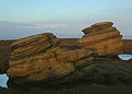
The Coach and Horse or Wheel Stones, approximately 25 feet (7.6 m) high
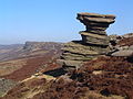
Salt Cellar with the edge visible in the background


References[]
- ^ a b c d "Back Tor". www.hill-bagging.co.uk. Retrieved 10 March 2016.
Bibliography[]
- Richards, Mark (1985). High Peak Walks. Cicerone Press. ISBN 0-902363-43-3.
External links[]
Coordinates: 53°24′00″N 1°42′25″W / 53.400°N 1.707°W
Peaks of the Peak District of England | ||
|---|---|---|
| Marilyns |  | |
| Other peaks |
| |
List of peaks of the Peak District | ||
- Hills and edges of South Yorkshire
- Mountains and hills of the Peak District
- Mountains and hills of Derbyshire
- Climbing areas of England
- Escarpments of England