Deverall Island
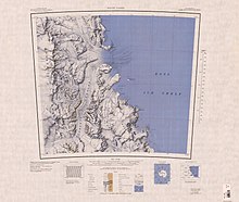
Map sheet showing Deverall Island
Deverall Island (81°28′S 161°54′E / 81.467°S 161.900°ECoordinates: 81°28′S 161°54′E / 81.467°S 161.900°E) is a small ice-covered island, rising above the Ross Ice Shelf just northeast of Beaumont Bay. It was named by the New Zealand Geological Survey Antarctic Expedition (1960–61) for , a radio operator at Scott Base, 1961.[1] It is considered to be the southernmost island in the world.
 WikiMiniAtlas
See also[]
- List of antarctic and sub-antarctic islands
References[]
- ^ "Deverall Island". Geographic Names Information System. United States Geological Survey. Retrieved 2012-01-16.
![]() This article incorporates public domain material from the United States Geological Survey document: "Deverall Island". (content from the Geographic Names Information System)
This article incorporates public domain material from the United States Geological Survey document: "Deverall Island". (content from the Geographic Names Information System)
This Shackleton Coast location article is a stub. You can help Wikipedia by . |
Categories:
- Islands of the Ross Dependency
- Shackleton Coast
- Shackleton Coast geography stubs