Devil Canyon Creek
| Devil Canyon Creek[1] Devil Canyon | |
|---|---|
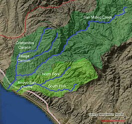 Map of San Mateo Creek and Arroyo San Onofre drainage
basins. San Mateo Creek basin is in dark green. | |
| Location | |
| Country | United States |
| State | California |
| Region | San Diego County |
| Physical characteristics | |
| Source | a flat in the Santa Margarita Mountains |
| • coordinates | 33°27′38″N 117°22′28″W / 33.46056°N 117.37444°W |
| • elevation | 2,440 ft (740 m) |
| Mouth | confluence with San Mateo Creek |
• coordinates | 33°28′24″N 117°27′57″W / 33.47333°N 117.46583°WCoordinates: 33°28′24″N 117°27′57″W / 33.47333°N 117.46583°W |
• elevation | 453 ft (138 m) |
| Length | 8 mi (13 km) |
| Discharge | |
| • location | Pacific Ocean |
| Basin features | |
| Tributaries | |
| • right | |

Devil Canyon Creek, a stream or arroyo, tributary to San Mateo Creek, in the Santa Margarita Mountains, all but its first and last part within the Cleveland National Forest in San Diego County, California. Its source is at an altitude of 2440 feet on a flat private land in the Santa Margarita Mountains.[2] and it flows southwestward then turns down into the canyon and the and northward 2 miles before turning westward toward its confluence in with San Mateo Creek at an elevation of 453 feet. The last half mile of the creek before this confluence is outside the National Forest boundary, and within the Camp Pendleton Marine Corps Base.[3] Devil Canyon has one named tributary, , draining the Santa Margarita Mountains north of the Devil Canyon watershed that enters it from the right about a mile and half above the confluence of Devil Canyon Creek with San Mateo Creek.[4][5]
References[]
- ^ U.S. Geological Survey Geographic Names Information System: Devil Canyon Creek
- ^ Devil Canyon Creek (source), USGS Map Name: Fallbrook, CA, Map Center: N33° 27' 38" W117° 22' 28" from topoquest.com accessed on 5/13/2013
- ^ Devil Canyon, California (mouth), USGS Map Name: Margarita Peak, CA Map Center: N33° 28' 24" W117° 27' 57", from topoquest.com accessed on 5/13/2013
- ^ Devil Canyon, California (mouth), USGS Map Name: Margarita Peak, CA Map Center: N33° 28' 44" W117° 26' 30", from topoquest.com accessed on 5/13/2013
- ^ Beatrice Dawson Wood, Gazetteer of Surface Waters of California, Pacific Coast Basins and Great Basin, U.S. Government Printing Office, Washington, 1913, p.67
- Rivers of San Diego County, California
- Santa Ana Mountains
- Cleveland National Forest
- Rivers of Southern California