Dewaitha
Some of this article's listed sources may not be reliable. (July 2021) |
This article may require copy editing for grammar, style, cohesion, tone, or spelling. (July 2021) |
Dewaitha
Daudpur | |
|---|---|
Village | |
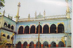 Purani Masjid of Dewaitha built in 1605 by Raja Daud Khan, founder of Dewaitha, | |
 Dewaitha Location in Uttar Pradesh, India | |
| Coordinates: 25°21′50″N 83°38′38″E / 25.364°N 83.644°ECoordinates: 25°21′50″N 83°38′38″E / 25.364°N 83.644°E | |
| Country | |
| State | Uttar Pradesh |
| District | Ghazipur |
| Established | 1605 |
| Founded by | Zamindar Daud khan |
| Government | |
| • Type | Panchayati Raj (India) |
| • Body | Gram Pradhan |
| Area | |
| • Total | 442.22 ha (1,092.75 acres) |
| Elevation | 70 m (230 ft) |
| Population (2011) | |
| • Total | 7,104 |
| • Density | 1,600/km2 (4,200/sq mi) |
| Demonym(s) | Kamsaari |
| Languages | |
| • Official | Bhojpuri, Hindi |
| Time zone | UTC+5:30 (IST) |
| PIN | 232326[1] |
| Telephone code | 05497 |
| Vehicle registration | UP 61 |

Dewaitha (also spelt as Devaitha) is a village in Dildarnagar Kamsar, Ghazipur, India, on the banks of the Karmanasa River. The village has a population of 7104, as of the 2011 census, and an area of 1043 acres. Most of the people living in the village are Hindu. The then-Muslim Dewaitha village was the capital of the Daudpur estate.[2][3][4][5]
History[]
Early history (1605–1764)[]
Dewaitha was established in the year 1605 AD by Diwan Jagirdar Taluka Daudpur Zamindar Raja Daud Khan (b.1582), a great-grandson of Narhar Khan (the founder of Dildarnagar Kamsar). Daud Khan also built a mosque in the village which is currently recognized as the Purani Masjid. Daud Khan walled off the area and fortified it. Some of the parts of Daud Khan's fort still exist. The eldest son of Daud Khan was Mammud Khan, who established Rasulpur Newada. Later, Mahmmud Khan's descendants also established . When the village was founded, it was also known as Daudpur in honor of Raja Daud Khan. He became a major Zamindar and Jagirdar of the region.[clarification needed]
Daud was made Jagirdar of Kamsaar which spread from Ghazipur to Kudra. He was also made the Dewan of Bihar Subah in the year 1605 by the Mughal emperor Jahangir after the death of his cousin Raja Quttul Khan (b.1581), who handled the post during Akbar. While Allauddin Islam Khan, a grandson of Salim Christi R.A was appointed as the Subahdar of Bihar but, after one year the post of Subahdar was given to Abdur Rahman, son of Abul Fazal in 1606. Daud Khan established a jagir or a zamindari estate named Daudpur jagir and talukdari in the year 1605. On which Daud's descendants ruled for 347 years. During the period of Daud, Daudpur estate extended from the city of Bhabua to Chandauli and from Buxar to Chandauli.[clarification needed]
Shahjahan succeeded Jahangir as the Mughal emperor in 1628. Daud Khan was again made the Dewan of Bihar while, Shajahan appointed Mirza Barkhuwlar as the Subahdar of Bihar. However, after 4 years, Mirza Barkhuwalar was removed from the post and Abdullah Khan Bahadur Firoz jang succeeded as the Subahdar in 1632. It is said[weasel words] that it was Daud's influence because of which Abdullah Khan made Ikhlash Khan a commandent of Rohtas, Kiladar of Rohtas fort and faujdar of territories extending from sri and Katarba to Banaras and a jagirdar of Khawand in 1634. Akhlash Khan nominated Malik Wishal Khan as the daroga of Rohats fort in 1634. Later, Ikhlash Khan also became the Subahdar of Bihar in 1656. Ikhlash Khan later established Ikhlashpur near Bhabua. It is said[weasel words] that Daud Khan's family later, had good relationships with Ikhlash Khan and his family and one of Daud's descendants established Sikhati village near Ikhlashpur. [6][7][8][verification needed][clarification needed]
Following the battle of Buxar (1764–1837)[]
After the battle of Buxar, Raja Kadir Khan became the next Raja-zamindar in 1765 succeeding his grandfather. He had three younger brothers, named Haider Ali Khan, Hamid Ali Khan and Yad Ali Khan. He was succeeded by Yad Ali who was his youngest brother in 1785. They still continued to have their ancestral title of Raja. Yad Ali Khan became a famous man of his time. Yad Ali got a ancestral estate and Talukdari composing of 438 villages but later he increased it to 532 villages. His estate stretched from Dildarnagar to . Yad Ali died at the end of 1837 and was succeeded by his eldest grandson Khuda Bhakhs Khan. [6][7][8][clarification needed]
Zamindarship of Khuda Bhaksh Khan onwards (1837–1952)[]
Khuda Bhaksh Khan renovated the old fort of Dewaitha in 1838. The Raja of Banaras wanted to abolish the zamindari of Daudpur but Khuda Bhakhs Khan went to court. The hearing was at Fort Williams of Calcutta in 1842, and judgment was in the favour of Khuda Bhakhs Khan. Khuda Bhaksh Khan had three younger brothers named Ameer Khan, Fateh Bahadur Khan and Akbar Khan, of whom the youngest named Akbar Khan was martyred in the rebellion of 1857-1859. Khuda Bhaksh also led the Kamsar Pathans during the rebellion. It is said that nearly 1500 Kamsaries participated with Khuda Bhaksh. During the rebellion of 1857, the British destroyed most of the part of the old fort of Daudpur where Khuda Bhaksh family use to live.[clarification needed]
So, Khuda Bhakhs with his two younger brothers shifted outside of the fort and build three large houses and fortified them. later, these houses were further divided among their sons in year 1887 and the place got the name Athoghar. Khuda Bhakhs Khan also built a kot at Ramgarh and Kot and . He also bought 40 acres of land near the town of Dildarnagar and established Karimpura Bazaar in 1870. The bazaar consisted of 300 shops in 1947 and a rice mill which was established by a grandson of Khuda Bhakh in 1898. Khuda Bhaksh Khan was succeeded by his younger brother named Ameer Khan.[clarification needed] Ameer Khan was then succeeded by his elder son Jagirdar Muhammad Alam Shah Khan Raies. Alam Shah was succeeded by his second son named Jagirdar Muhammad Wasil Khan Rais in 1935. He also established the Jalalpur village.[6][7][8][verification needed]
Following the abolition of the zamindari system (1952–present)[]
After the abolition of Zamindari in 1952, he was still the chief or Pradhan of 79 villages, and was known as Raja. He also established a High school at Dewaitha in 1928. Now the high school is intercollege. In 1959, he won the pradhani election and became the first pradhan of Dewaitha. He became pradhan again in 1964. Till 1994, the Dewaitha gram Panchayat had 65 villages and was the largest gram Panchayat by area and population in Ghazipur.[8][6][full citation needed]
Demographics[]
As of the 2011 census, the total area of the village is 442.22 hectares. The village has a total population of 7,104, as well as 917 households.[2][5][4]
Historical population[]
| showPopulation Growth of Dewaitha |
|---|
Pradhans[]
- Muhammad Wasil Khan (1959–1969)
- Afzarul haq Khan (1969–1984)
- Jalaluddin Khan (1984–1989)
- Iqbal Khan (1989–1999)
- Jamaluddin Khan (1999–2004)
- Suraiya Khanum (2004–2009)
- Najrin (2009–2014)
- Aslam Khan Seth (2015–2021)
- Haji Gyasudin khan (2021–2026)[citation needed]
References[]
- ^ "Pin Code: Dewaitha, Ghazipur, Uttar Pradesh, India, Pincode.net.in". PINCode Search, Post Office Details, All India Post Office Data Pincode.net.in. Retrieved 3 September 2018.
- ^ Jump up to: a b "Pincode of Dewaitha village in Zamania tehsil pf Ghazipur District".
- ^ "Bhulekh".
- ^ Jump up to: a b "2011 census of India".
- ^ Jump up to: a b "Panchyati Raj, Ghazipur".
- ^ Jump up to: a b c d Khan, Suhail. Kamsarnama.
- ^ Jump up to: a b c Nevill, H. R. (1909). Ghaziper: A Gazetteer (PDF). Retrieved 14 April 2021.
- ^ Jump up to: a b c d Ansari, Saiyad Hasan (1986). Evolution and Spatial Organization of Clan Settlements: A Case Study of Middle Ganga Valley. Concept Publishing Company.
- ^ "Census of India". mospi.gov.in. Archived from the original on 13 August 2008. Retrieved 23 June 2008.
- ^ "2011 census of India".
- Cities and towns in Ghazipur district
- Towns and villages in Kamsar
- Villages in Ghazipur district