Diablo Dam
| Diablo Dam | |
|---|---|
 | |
| Location | Washington, United States |
| Opening date | 1930 |
| Dam and spillways | |
| Type of dam | Concrete arch-gravity[1] |
| Impounds | Skagit River |
| Height | 389 ft (119 m)[1] |
| Length | 1,180 ft (360 m)[1] |
| Reservoir | |
| Total capacity | 88,500 acre⋅ft (109,200,000 m3)[1] |
| Catchment area | 1,103 sq mi (2,860 km2)[1] |
| Surface area | 990 acres (400 ha)[1] |
| Commission date | 1936 |
| Turbines | 2x 64.5 MW[2] |
| Installed capacity | 129 MW[2] |
| Capacity factor | 61% |
| Annual generation | 689,400,000 KWh[3] |
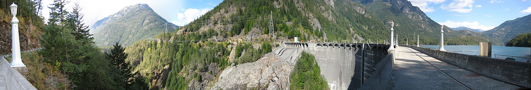
Diablo Dam is one of three dams along the upper Skagit River in Whatcom County, Washington and part of the Skagit River Hydroelectric Project that supplies Seattle with some of its power needs. The dam was built in Diablo Canyon, a gorge of solid granite with vertical walls rising 160 feet (49 m) from the river bed, yet were less than 100 feet (30 m) apart. Construction began in 1927, and was completed in 1930. The dam began generating electricity in 1936.[4]
The result was a power-generating dam that holds a reservoir known as Diablo Lake. At the time it was completed, Diablo Dam, at 389 feet (119 m), was the tallest dam in the world.[5] Water from the dam operates two main generators, each with a capacity of 64.5 MW.[2]Coordinates: 48°42′51″N 121°07′52″W / 48.7143°N 121.1312°W

Climate[]
The Western Regional Climate Center (WRCC) reports weather station 452157 at Diablo Dam since 1948, presently at 48°42′51″N 121°08′35″W / 48.71417°N 121.14306°W with an elevation of 891 feet (272 m).[6]
| hideClimate data for Diablo Dam, Washington | |||||||||||||
|---|---|---|---|---|---|---|---|---|---|---|---|---|---|
| Month | Jan | Feb | Mar | Apr | May | Jun | Jul | Aug | Sep | Oct | Nov | Dec | Year |
| Record high °F (°C) | 62 (17) |
63 (17) |
76 (24) |
90 (32) |
103 (39) |
101 (38) |
106 (41) |
106 (41) |
101 (38) |
87 (31) |
65 (18) |
59 (15) |
106 (41) |
| Average high °F (°C) | 37.3 (2.9) |
42.6 (5.9) |
48.8 (9.3) |
57.1 (13.9) |
65.3 (18.5) |
70.5 (21.4) |
77.5 (25.3) |
77.6 (25.3) |
70.8 (21.6) |
57.8 (14.3) |
44.8 (7.1) |
38.4 (3.6) |
57.4 (14.1) |
| Average low °F (°C) | 27.3 (−2.6) |
29.6 (−1.3) |
32.4 (0.2) |
36.9 (2.7) |
42.8 (6.0) |
48.2 (9.0) |
51.9 (11.1) |
52.5 (11.4) |
47.8 (8.8) |
41.0 (5.0) |
34.0 (1.1) |
29.8 (−1.2) |
39.5 (4.2) |
| Record low °F (°C) | −8 (−22) |
0 (−18) |
9 (−13) |
24 (−4) |
28 (−2) |
33 (1) |
38 (3) |
37 (3) |
31 (−1) |
18 (−8) |
5 (−15) |
−2 (−19) |
−8 (−22) |
| Average precipitation inches (mm) | 11.47 (291) |
8.09 (205) |
7.12 (181) |
4.59 (117) |
2.84 (72) |
2.26 (57) |
1.41 (36) |
1.46 (37) |
3.45 (88) |
8.05 (204) |
11.88 (302) |
12.46 (316) |
75.08 (1,906) |
| Average snowfall inches (cm) | 21.2 (54) |
12.1 (31) |
7.0 (18) |
0.3 (0.76) |
0.0 (0.0) |
0.0 (0.0) |
0.0 (0.0) |
0.0 (0.0) |
0.0 (0.0) |
0.1 (0.25) |
3.8 (9.7) |
16.1 (41) |
60.6 (154.71) |
| Source: [7] | |||||||||||||
Panorama[]
See also[]
References[]
| Wikimedia Commons has media related to Diablo Dam. |
- ^ Jump up to: a b c d e f "Diablo (WA00170)". National Performance of Dams Program (Stanford University). Archived from the original on 2016-03-05. Retrieved 2014-03-04.
- ^ Jump up to: a b c "City Light Projects Harness Powerful Skagit River After Long, Hard Struggle" (PDF). The Concrete Herald. 1951-06-21. Retrieved 2009-09-05.
- ^ "Diablo". Carbon Monitoring for Action (CARMA). Archived from the original on 2016-03-03.
- ^ "Power Generation: Skagit Project - Diablo Dam". City of Seattle. Retrieved 2011-01-06. Includes construction photos.
- ^ "Washington State Tourism Diablo Dam/Lake". Retrieved 2009-09-05.
- ^ "Washington Station Inventory". Western Region Climate Center. Retrieved 2020-05-18.
- ^ "DIABLO DAM, WASHINGTON (452157)". Western Regional Climate Center. Retrieved 2016-06-01.
External links[]
- Diablo Dam, 1929-1932 (Part 1) (Part 2) (Part 3) – silent film clips of construction posted by Seattle Municipal Archives on YouTube
| show Authority control |
|---|
This Whatcom County, Washington state location article is a stub. You can help Wikipedia by . |
- Dams in Washington (state)
- Seattle City Light dams
- Buildings and structures in Whatcom County, Washington
- Hydroelectric power plants in Washington (state)
- United States power company dams
- Dams completed in 1930
- Energy infrastructure completed in 1936
- Arch dams
- Dams on the Skagit River
- National Register of Historic Places in Ross Lake National Recreation Area
- Whatcom County, Washington geography stubs