Dodewaard
Dodewaard | |
|---|---|
 Flag  Coat of arms | |
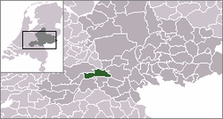 | |
 The town centre (red) and the statistical district (light green) of Dodewaard in the municipality of Neder-Betuwe. | |
| Country | Netherlands |
| Province | Gelderland |
| Municipality | Neder-Betuwe |
| Population | ca. 4,500 |
Dodewaard (51°55′N 5°39′E / 51.917°N 5.650°E) is a town in the Dutch province of Gelderland. It is a part of the municipality of Neder-Betuwe, and lies about 7 km south of Wageningen.
 WikiMiniAtlas
Dodewaard was a separate municipality until 2002, when it became a part of Kesteren. Before 1818, the municipality was called "Hien en Dodewaard".[1]
In 2001, the town of Dodewaard had 3090 inhabitants. The built-up area of the town was 1.1 km², and contained 1166 residences.[2] The statistical area "Dodewaard", which also can include the peripheral parts of the village, as well as the surrounding countryside, has a population of around 4330.[3] It also houses the now defunct Dodewaard Nuclear Power Plant.
References[]
- ^ Ad van der Meer and Onno Boonstra, Repertorium van Nederlandse gemeenten, KNAW, 2011.
- ^ Statistics Netherlands (CBS), Bevolkingskernen in Nederland 2001 Archived 19 March 2006 at the Wayback Machine. (Statistics are for the continuous built-up area).
- ^ Statistics Netherlands (CBS), Statline: Kerncijfers wijken en buurten 2003-2005 Archived 24 July 2006 at WebCite. As of 1 January 2005.
External links[]
- J. Kuyper, Gemeente Atlas van Nederland, 1865-1870, "Dodewaard". Map of the former municipality, around 1868.
| hide Authority control | |
|---|---|
| General | |
| National libraries | |
This Gelderland location article is a stub. You can help Wikipedia by . |
- Populated places in Gelderland
- Former municipalities of Gelderland
- Neder-Betuwe
- Gelderland geography stubs