Donga River
Northwest region of Cameroon. Donga River in the north.
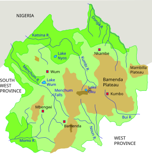
The Donga River is a river in Nigeria and Cameroon. The river arises from the Mambilla Plateau in Eastern Nigeria, forms part of the international border between Nigeria and Cameroon, and flows northwest to eventually merge with the Benue River in Nigeria. The Donga watershed is 20,000 square kilometres (7,700 sq mi) in area. At its peak, near the Benue the river delivers 1,800 cubic metres (64,000 cu ft) of water per second.[1]
In Taraba State, Nigeria, there are three forest reserves, Baissa, Amboi and Bissaula River, in the Donga river basin. They lie on the slopes and at the foot of the Mambilla Plateau, south-west of Gashaka Gumti National Park.[2]
See also[]
References[]
- ^ Inger Andersen; Ousmane Dione; Martha Jarosewich-Holder; Jean-Claude Olivry (2005). "The Niger River Basin: A Vision for Sustainable Management" (PDF). World Bank. Retrieved 2011-02-06.
- ^ "Donga river basin forests". BirdLife International. Retrieved 2011-02-06.
Coordinates: 7°09′44″N 10°34′18″E / 7.162128°N 10.571594°E

Categories:
- Rivers of Nigeria
- Rivers of Cameroon
- International rivers of Africa
- Cameroon–Nigeria border
- Africa river stubs
- Nigeria geography stubs
- Cameroon geography stubs