Doora, County Clare
Doora
Dúire | |
|---|---|
Civil parish | |
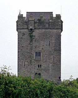 Castlefergus or Ballyhannon Castle | |
 Doora | |
| Coordinates: 52°49′56″N 8°55′09″W / 52.832331°N 8.919067°WCoordinates: 52°49′56″N 8°55′09″W / 52.832331°N 8.919067°W | |
| Country | Ireland |
| Province | Munster |
| County | County Clare |
| Time zone | UTC+0 (WET) |
| • Summer (DST) | UTC-1 (IST (WEST)) |

Doora (Irish: Dúire[1]) is a civil parish and village in County Clare, Ireland, just to the east of the town of Ennis. It is part of the Catholic parish of Doora Barefield. Parts of Doora are contained in the town of Ennis.
Name[]
In Irish the word Dúr means "water", and Dúire means "of water", so the name means the parish of the water or bog.[2]
Location[]
The parish is on the western border of the barony of Bunratty Upper, just east of the town of Ennis. It is 3.75 by 3 miles (6.04 by 4.83 km) and covers 5,927 acres (2,399 ha). The land includes bog, upland pasture and farmland. It is drained by the River Quin, which runs southwest into the River Fergus. The population in 1841 was 2,365 in 370 houses.[3] While the original eponymous hamlet decayed, a new settlement developed around Doora Church.
Antiquities[]
The history of Saint Brecan of Arran says he founded a church in Daclais that is named after him. According to James Frost the townland of Kilbreckan holds the ruined church of Carrantemple, a very old building, which may be this church.[2] In fact Carntemple lies in the adjacent townland of Noughaval.[4] Doora Church may have been founded by Saint Brecan around 500 AD.[5] If Brecan was the founder, as tradition states, it would have been one of the first central mission churches in Clare.[6] An 1842 map notes that the church was in ruins and shows it about 200 metres (660 ft) southwest of what was then the hamlet of Doora, in the west of the townland of Ballaghboy. It was about 300 metres (980 ft) east of the River Fergus, opposite the town of Ennis.[4] There is also a ruined church named Kellavella.[7] Two holy wells in the parish are dedicated to Saint Breccan.[2]
The parish has the remains of two castles. Ballyhannon Castle was the property of William Neylan in 1580. Renamed Castlefergus, it was still well preserved in 1893.[7] The castle has since been restored and may be rented.[8] The other castle, Clonmore, was completely ruined by the end of the 19th century.[7] As of 1845 the principal hamlets were Dowry and Ballaghboy. The parish name at that time was variously spelled Doora, Dowry, or Dowrie.[3]
A notable native of the parish was Michael Considine of Castletown townland, who composed the famous folk song Spancil Hill in the early 1870s.
Sports[]
The Gaelic Athletic Association (GAA) club, St Josephs Doora-Barefield GAA, has its grounds in the parish with three playing pitches in the Gurteen townland (52°50′32″N 8°54′23″W / 52.842086°N 8.906281°W).[9]
Catholic parish[]
In 1837 the parish was united in the Catholic church with the parish of Kilraghtis.[10] Doora today is in the Catholic parish of Doora and Kilraghtis, also called Doora Barefield, in the Roman Catholic Diocese of Killaloe.[11] The parish also covers Barefield in Templemaley and part of Ennis. The church of St Breckan's is in Noughaval townland.[12] Doora National School in Deerpark townland (52°49′12″N 8°54′47″W / 52.819865°N 8.913131°W) is run by the Doora-Barefield parish.[13]
Townlands[]
The parish contains the townlands of Ardsollus, Ballaghboy, Ballyglass, Ballyortla (North), Ballyortla (South), Ballyvonnavaun, Bunnow, Castlefergus, Castletown, Cloonawee, Cloonmore, Corebeg, Creggaun, Deerpark, Dooneen, Drim, Drumdoolaghty, Finanagh, Gaurus, Gortataggart, Gorteen, Kilbreckan, Kilfeilim, Killawinna, Knockanean, Knockaskibbole, Knockhogan, Monanoe, Moyriesk and Noughaval.[14]
The townlands of Castlefergus and Ardsollus are isolated from the rest of the parish, a small distance to the south.[14] The town of Ennis includes the townlands of Ballaghboy, Bunnow, Gaurus, and Knockanean. Ennis also covers parts of the parishes of Drumcliff, Kilraghtis and Templemaley.[15]

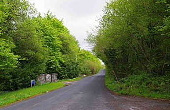
Junction of country road with R469, Ennis

Junction of N85 with M18 - View of the M18 to North from the N85

Reedbed in the townland of Kilbreckan
L4104 road near Finanagh


References[]
- ^ Dúire, Placenames Database of Ireland.
- ^ a b c Frost 1893, p. 49.
- ^ a b Parliamentary Gazetteer of Ireland 1845.
- ^ a b 1842 Ordnance Survey 6-Inch Maps of County Clare.
- ^ Westropp 1900, p. 147.
- ^ Westropp 1894.
- ^ a b c Frost 1893, p. 50.
- ^ Ballyhannon Castle.
- ^ About Us, St Joseph’s Doora Barefield.
- ^ Lewis 1837, p. 37.
- ^ "Our Parish". Doora-Barefield parish. Retrieved 31 March 2014.
- ^ Doora and Kilraghtis, Diocese of Killaloe.
- ^ Schools, Doora-Barefield Parish.
- ^ a b Map of Doora Parish showing Townlands.
- ^ Ennis (Inis), Clare Library.
| Wikimedia Commons has media related to Doora. |
Sources[]
- 1842 Ordnance Survey 6-Inch Maps of County Clare, Clare County Library, retrieved 16 January 2015
- "About Us". St Joseph’s Doora Barefield. Retrieved 12 April 2014.
- "Ballyhannon Castle". Ballyhannon Castle. Retrieved 13 April 2014.
- "Doora and Kilraghtis". Diocese of Killaloe. Retrieved 31 March 2014.
- "Dúire". Placenames Database of Ireland. Retrieved 10 April 2014.
- "Ennis (Inis)". Clare County Library. Retrieved 12 April 2014.
- Frost, James (1893). The History and Topography of the County of Clare: From the Earliest Times to the Beginning of the 18th Century. author. p. 49. Retrieved 8 March 2014.
- Lewis, Samuel (1837). County Clare, A History and Topography. Ennis: CLASP Press. ISBN 1-900545-00-4. Retrieved 12 April 2014.
- "Map of Doora Parish showing Townlands". Clare County Library. Retrieved 8 March 2014.
- "Our Parish". Doora-Barefield parish. Retrieved 8 March 2014.
- "Doora, Dowry, or Dowrie". Parliamentary Gazetteer of Ireland. 1845. Retrieved 8 March 2014.
- "Schools". Doora-Barefield Parish. Retrieved 12 April 2014.
- Westropp, Thomas Johnson (1894). "Churches with Round Towers in Northern Clare". Journal of the Royal Society of Antiquaries of Ireland. IV. Retrieved 16 January 2015.
- Westropp, Thomas Johnson (1900). The Churches of County Clare and the Origin of the Ecclesiastical Divisions in that County. PRIA.
- Civil parishes of County Clare
- Towns and villages in County Clare