Doukkala
Doukkala | |
|---|---|
 The "Green Mountain", the only visible hill, east of the region | |
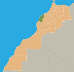 Location of the Doukkala natural region in Morocco | |
| Country | Morocco |
Doukkala (Berber: ⴷⵓⴽⴽⴰⵍⴰ, Arabic: دكالة, romanized: Dukkālah) is a natural region of Morocco made of fertile plains and forests. Nowadays it is part of the Casablanca-Settat administrative region.
It is a plain stretching from the Atlantic Ocean south of Sidi Rahal Chatai up to some 50 km further southward and the same distance eastward.
The main urban centers are Sidi Smail, Sidi Bennour, , . Sidi Bennour is the fastest developing center of the four.
It is mainly an agricultural region, with few tourist attractions.
History[]
Historically, Doukkala referred to a confederation of Berber tribes which occupied the territory between the rivers of Oum Er-Rbia River and Tensift and from the Atlantic Ocean to Jbilate near Marrakesh. They were part of the much larger tribal confederation of Barghawata that stretched from Anfa to Tensift and were an independent state from 744 AD to 1058 AD.
The Doukkalas were a mix of majority Masmuda: the Ragrâga, Hazmîra, Banû Dghûgh, Banû Mâgir, and Mushtarayya (Mouchtaraia), together with the SanHâja.[1] The SanHâja occuping the Atlantic coast between Azemmour and south of El Jadida.
When the Almohads under Abd al-Mu'min captured the town of Marrakesh in 1147, the Doukkals sided against them and in favor of the Almoravid dynasty. They were subsequently defeated by al-Mu'min, and purged, with women and children being sold into slavery.[2] Al-Mu'min brought in less fractious Arab bedouin tribes as immigrantes to settle the area, including the Banu Hilal, a coalition of whom he had defeated earlier in Tunisia.[3] Later immigrants included the al-Ma'qil.[1]
By 1250, of the Doukkala only the Ragrâga had survived intact after their conquest and the subsequent immigration of eastern tribes.[1]
Ever since the first installation of the Banu Hilal, there has been continuous mixing of both populations and it was even as late as the 16th century when it was possible to clearly distinguish the native Berber element from the Arab one. However, the Arabisation is now complete.
It is also worth mentioning that there are two factions: Chiadma who are related to the Chiadma et Chtouka from the Chtouka Ait Baha that were re-located to Doukkala North of the Oum Er-Rbia River.
At the end of the French protectorate (ca 1950), there lived in Doukkala 372,269 Muslims, 2,680 Europeans and 3,933 Jews. [4]
Geography[]
Doukkala is divided in three sub-regions, parallel to the seacoast.
- The "" (Arabic: ), along the beach, with garden-crops.
- The "Sahel" (Arabic: ), some 20 km inside, a stony region, only suiting to sheep breeding.
- The rich plain, with wheat, sugar beets, and intensive cattle breeding.
The only mountain to be seen is at the border with the plain of Rahamna called "Jbel Lakhdar" (Arabic: ) meaning "Green Mountain".
The plain is subject to flooding. A temporary natural lake between Sidi Bennour and called "" (Arabic: ) only fills in rainy years. Its largest surface was noted in 1916, 1966 and 2008.
Features of the Doukkala[]

Sugar beets cultivation at Sidi Smail
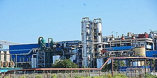
Sugar factory at Sidi Bennour

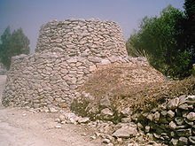
Center of a typical Doukkala village (Mwarid, Oulad Bou Hmam)
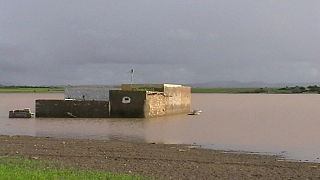
Warar, a natural temporary lake, in 2008, flooding a house built in the 1970s

"Sahel" sub-region, with "anticline climbing" road


References[]
- ^ a b c Park, Thomas K.; Boum, Aomar (2005). "Doukkala (dukkâla)". Historical Dictionary of Morocco (second ed.). Lanham, Maryland: Scarecrow Press. p. 105. ISBN 978-0-8108-5341-6.
- ^ Empey, Heather J. (2017). "The mothers of the caliph's sons: Women as Spoils of War during the Early Almohad Period". In Gordon, Matthew; Hain, Kathryn A. (eds.). Concubines and Courtesans: Women and Slavery in Islamic History. New York: Oxford University Press. pp. 143–162, page 151.
- ^ Fauvel, Jean-Jacques (1978). Le Guide bleu du Maroc (in French). Paris: Hachette Tourisme. p. 302.
- ^ Guide bleu Hachette du Maroc, 7th ed., 1950, p. 178.
External links[]
| Wikimedia Commons has media related to Doukkala. |

- Casablanca-Settat geography stubs
- Geography of Morocco
- Natural regions of Africa