Douma, Lebanon
Douma
دوما Duma | |
|---|---|
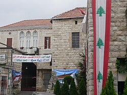 Center of Douma, 2009 | |
| Nickname(s): Douma al-Hadid (the Iron Douma) | |
 Douma Location in Lebanon | |
| Coordinates: Coordinates: 34°12′N 35°50′E / 34.200°N 35.833°E | |
| Country | Lebanon |
| Governorate | Mount Lebanon |
| District | Batroun |
| Founded by | Maalouf clan |
| Government | |
| Elevation | 1,150 m (3,770 ft) |

Douma (Arabic: دوما, romanized: Dūma) is a village in Lebanon located 80 km from Beirut, 30 km from Byblos and 43 km from Tripoli. Douma is a administratively part of Batroun District and is known for its location in a valley surrounded by mountains. It stands at an altitude of 1150 m. Almost all of its houses are covered in red tiles. It has a temperate climate and an abundance of vineyards and olive and apple groves.
History[]
Douma was populated since ancient times. In the town square sits a sarcophagus, bearing a Greek inscription recording that this was the burial place of Castor, who died in 317 AD.[citation needed] The village was almost abandoned until the 16th century, during Ottoman rule, when the modern village was founded by the Greek Orthodox Christian clan of the Maalouf, who migrated to the Byblos and Kisrawan areas from the Hauran.[1] The family continues to inhabit the village until the present day.[1] In 1880 the Ottoman mutasarrif of Mount Lebanon, Rustum Pasha, appointed a municipal council to administer Douma, the sixth locality to receive a council in Mount Lebanon.[2]

The Great Famine of Mount Lebanon during World War I precipitated a wave of emigrants from Douma to the Americas and their remittances significantly contributed to boosting the village's economy.[3] Most infrastructure and houses in Douma were built between 1881 and 1914, largely financed by emigrants from the village in Brazil, Argentina and the United States of America.[citation needed] In the 1920s, the leaders of Syria who had just rebelled against the French Mandatory rule, were detained and exiled to Douma of Lebanon. One of those leaders was Sa’dallah al-Jabiri who was destined to become Syria’s first Prime Minister after its independence in the 1940s. Another one was a main author of Syria’s constitution: lawyer Safadi.[citation needed]
Name[]

Douma is also named Dūma al-Hadīd (literally "Douma of iron" or "Iron Douma") due to the abundance of iron found in its soil and the superior craftsmanship of its blacksmiths. The arming industry established under Ibrahim Pasha's rule encouraged many people from Choueir to come and settle in Douma since opportunities of work were plentiful at the time.[citation needed]
Climate[]
Douma has a Mediterranean climate. Rainfall is higher in winter than in summer. The Köppen-Geiger climate classification is Csa. The average annual temperature in Douma is 15.2 °C (59.4 °F). About 1,210 mm (47.64 in) of precipitation falls annually.
| hideClimate data for Douma | |||||||||||||
|---|---|---|---|---|---|---|---|---|---|---|---|---|---|
| Month | Jan | Feb | Mar | Apr | May | Jun | Jul | Aug | Sep | Oct | Nov | Dec | Year |
| Average high °C (°F) | 10.7 (51.3) |
11.0 (51.8) |
13.8 (56.8) |
18.9 (66.0) |
23.4 (74.1) |
27.2 (81.0) |
29.5 (85.1) |
30.1 (86.2) |
27.2 (81.0) |
23.6 (74.5) |
17.9 (64.2) |
13.3 (55.9) |
20.6 (69.0) |
| Average low °C (°F) | 2.8 (37.0) |
3.1 (37.6) |
4.7 (40.5) |
8.1 (46.6) |
11.6 (52.9) |
14.7 (58.5) |
16.4 (61.5) |
17.2 (63.0) |
14.7 (58.5) |
12.3 (54.1) |
8.4 (47.1) |
4.9 (40.8) |
9.9 (49.8) |
| Average precipitation mm (inches) | 265 (10.4) |
222 (8.7) |
202 (8.0) |
87 (3.4) |
35 (1.4) |
2 (0.1) |
1 (0.0) |
1 (0.0) |
9 (0.4) |
43 (1.7) |
124 (4.9) |
219 (8.6) |
1,210 (47.6) |
| Source: Climate-Data.org,Climate data | |||||||||||||
Twin towns[]
 Digne-les-Bains, France
References[]
- ^ Jump up to: a b Harris, William (2012). Lebanon: A History, 600–2011. New York: Oxford University Press. p. 90. ISBN 978-0-19-518-111-1.
- ^ "Joseph Khairallah Maalouf - Head of the Municipality of Douma". The Monthly Magazine. 8 March 2014. Retrieved 26 June 2020.
- ^ Kadi, Samar (4 July 2019). "Lebanon's Douma village where Levantine traditions survive". The Arab Weekly. Retrieved 26 June 2020.
External links[]
- Duma, Localiban

- Populated places in the North Governorate