Doux (river)
| Doux | |
|---|---|
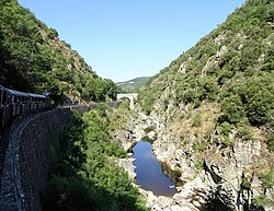 Gorges du Doux | |
 | |
| Location | |
| Country | France |
| Physical characteristics | |
| Source | |
| • location | Massif Central |
| Mouth | Rhône |
• location | Tournon-sur-Rhône |
• coordinates | 45°04′22″N 4°49′45″E / 45.0729°N 4.8292°ECoordinates: 45°04′22″N 4°49′45″E / 45.0729°N 4.8292°E |
| Length | 70 km (43 mi) |
| Basin features | |
| Progression | Rhône→ Mediterranean Sea |

The Doux is a tributary of the Rhône in the Haute-Loire and Ardèche departments, France. It is 70 km (43 mi) long.[1] It begins in the Massif Central and joins the Rhône in Tournon-sur-Rhône. It passes through the town Lamastre. The Chemin de fer du Vivarais heritage railway from Tournon-sur-Rhône to Lamastre runs through the Doux valley.
References[]
| Wikimedia Commons has media related to Doux River. |
This Ardèche geographical article is a stub. You can help Wikipedia by . |
This Haute-Loire geographical article is a stub. You can help Wikipedia by . |
Categories:
- Tributaries of the Rhône
- Massif Central
- Rivers of France
- Rivers of Ardèche
- Rivers of Haute-Loire
- Rivers of Auvergne-Rhône-Alpes
- Ardèche geography stubs
- Haute-Loire geography stubs
- France river stubs