Downtown Connector
  | ||||
|---|---|---|---|---|
| James Wendell George Parkway | ||||
 | ||||
| Route information | ||||
| Maintained by Georgia DOT | ||||
| Length | 7.4 mi[2] (11.9 km) | |||
| Existed | 1952[1]–present | |||
| Component highways | ||||
| Major junctions | ||||
| South end | ||||
| North end | ||||
| Location | ||||
| Counties | Fulton | |||
| Highway system | ||||
| ||||
| ||||
In Downtown Atlanta, the Downtown Connector or 75/85 (pronounced "seventy-five eighty-five") is the concurrent section of Interstate 75 and Interstate 85 through the core of the city. Beginning at the I-85/Langford Parkway interchange, the Downtown Connector runs generally due north, meeting the west–east I-20 in the middle. Just north of this is the Grady Curve around Grady Memorial Hospital. Continuing north, the terminus of the Downtown Connector is the Brookwood Interchange or Brookwood Split in the Brookwood area of the city. The overall length of the Downtown Connector is approximately 7.5 miles (12 km).[2] Since the 2000s, it has been officially named James Wendell George Parkway for most of its length, although it is still designated the Connector in the mainstream. It also has unsigned designations State Route 401 (I-75) and State Route 403 (I-85) along its length, due to I-75 and I-85 having 400-series reference numbers.
History[]
The Downtown Connector had its origins in the city's original system of expressways, construction of which began in the early 1950s with the Northeast Expressway and the South Expressway. Construction of the "connector" between the two, which was numbered State Route 295,[3] and was slated to carry US 19/US 41 at one point, was not completed until the early 1960s.[4]
Initial construction of the highway displaced parts of Techwood Drive and Williams Street in Midtown Atlanta. It also destroyed street grids east and south of downtown, dividing Sweet Auburn in two and the interchange with I-20 leveling the northern part of the Washington-Rawson district. The proposed I-485 was originally planned by the Georgia Department of Transportation to carry some south–north traffic through the eastern side of the city, but most of this was canceled in the 1970s by the then-governor of Georgia, Jimmy Carter (parts of that road are now I-675 and SR 400).[5]
The highway was heavily reconstructed during the 1980s as part of GDOT's Freeing the Freeways program to widen Atlanta-area freeways, with most of the Connector's width being doubled from three to six or seven lanes in each direction. [6] The project included work to increase lanes from six to eight on I-20, I-75, I-85, and I-285 ("The Perimeter"), as well as ten lanes on the downtown connector, involving 126 total miles and was phased over 13 years between 1976 and 1988. The improvement campaign also included elimination of sharp curves and grades, left-hand exits, excessive interchanges, and short acceleration/deceleration lanes.
So as to offer a bypass around construction through the center of the city, the perimeter road (I-285) was completed first. The radiating expressways were then upgraded, and the last phase was reconstruction of the depressed sections through downtown Atlanta. By June 1983, some $252 million in discretionary funds had been used to complete most of the highways save for some major interchanges and the downtown section. The eight miles of the downtown section, which includes the 4.4-mile long downtown connector, was the most complicated section of the entire reconstruction. Work was started on it in 1984, and it included redesigning the massive interchange between I-20 and I-75/85 at Memorial Drive where much of the mileage was on structure. The downtown connector was to be widened to ten lanes, and this required quite a bit of right of way acquisition. Many bridges, including the 55 over the connector portion alone, had to be designed and built. [5] In addition to the general-purpose lanes, provisions for high-occupancy vehicle (HOV) lanes and dedicated on-ramps at Williams Street, Piedmont Avenue, and Memorial Drive were built, and were subsequently converted to HOV usage in 1996.
Between 2000 and 2004, the six-lane wide 17th Street Bridge was constructed over the Brookwood Interchange, connecting Midtown Atlanta with the then-new Atlantic Station development. In 2008, reconstruction of the 14th Street Bridge took place in order to accommodate increased traffic flow and pedestrian amenities. This work also included the construction of two new off-ramps: a southbound ramp to 10th Street, and a northbound ramp to 17th Street. This work was completed on May 28, 2010.
In early January 2010, a section of the highway between 14th and 17th streets developed an unusual problem dubbed "phantom ice" during a prolonged cold wave that kept temperatures below freezing for several days in the Atlanta region. GDOT engineers believe that heavy rain in previous months raised the water table and caused it to seep upward through joints between lanes, where it subsequently froze. Commuter traffic was stopped briefly on at least two days in order to treat it with deicing materials and inspect the freeway to determine the cause.[7]
In January 2016, GDOT started a study of the Downtown Connector. Citing high levels of congestion that occur outside of peak periods, the purpose of the study is to gather data and explore options for reducing congestion.[8] Data collection took place all year in 2016, and the data is being analyzed and options evaluated throughout 2017 and 2018. The study is expected to be completed in 2019.[9] The study has already released their data on their website, including nine "Hot Spots", or dangerous and congested points that could most benefit from design improvements,[10] and a detailed analysis of traffic in the whole metro area and how it relates to traffic on the Downtown Connector.[11]
The Stitch[]
In August 2016, Central Atlanta Progress announced plans to cover the Downtown Connector, converting it to a subterranean roadway and building a series of greenspaces on top of the road, similar to Klyde Warren Park in Dallas. This project was drafted by Jacobs Engineering Group and is called "The Stitch", as one of the intents of the project would be to "stitch" together roads that had been divided with the creation of the Downtown Connector.[12] As of 2019, the project was still in the pre-construction phase, with an estimated timeline and budget of ten years and $452 million, respectively.[13]
Features[]
The Downtown Connector carries more than 437,000 vehicles per day at its busiest point — just south of 10th Street in Midtown, while the least traveled portion carries 243,000 vehicles per day — just south of Fulton Street, near the interchange with Interstate 20.[14] The area around the connector and associated interchanges are considered one of the ten-most congested stretches of interstate in the U.S.[15] Due to this fact, many motorists often compare Atlanta to Los Angeles, which is also known for its notoriously-congested freeway system.
The highway is fully instrumented with Intelligent transportation system (ITS) devices. There are more than 25 closed-circuit television cameras between the Langford Parkway interchange (south end) and the Brookwood Interchange (north end). Additionally, the Downtown Connector has three large overhead electronic message signs, and four smaller HOV-dedicated message signs on the median barrier wall. Traffic flow data is gathered through a video detection system, using pole-mounted black-and-white cameras spaced every 1⁄3 mile (0.54 km) on both sides of the roadway. All video and data is fed into the GDOT's Transportation Management Center (TMC), via fiber optic cable located under the shoulders of the roadway. Virtually all entrance ramps are metered, with the exception of the freeway-to-freeway connection ramps from I-20. As with every other freeway inside the Perimeter, the Downtown Connector is lined with streetlights mounted in the center median, with high-mast lighting at major interchanges.
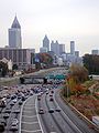
Atlanta's skyline, both Downtown and Midtown, can be seen from the highway, especially at the northern and southern ends.
Gallery[]

Southern end of the Downtown Connector where I-75 and I-85 diverge
North end of the Downtown Connector where I-75 and I-85 converge in Midtown

Downtown Connector view of the downtown skyline

Downtown Connector facing south from Fifth Street bridge; nighttime view
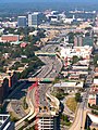
Aerial view of the Downtown Connector facing north from downtown

Aerial view of the Downtown Connector facing south from downtown

Atlanta Downtown Connector at night


Exit list[]
Exit numbers follow the mileposts along I-75. The entire route is in Atlanta, Fulton County.
| mi | km | Old exit | New exit | Destinations | Notes | ||
|---|---|---|---|---|---|---|---|
| 0.0 | 0.0 | 87 | 242 | Southern end of I-75/I-85 concurrency; southbound exit and northbound entrance; freeway continues with HOV lanes to and from I-75 to the south (no HOV ramps to or from I-85 to the south). | |||
| 0.6 | 0.97 | 88 | 243 | ||||
| 1.7 | 2.7 | 89 | 244 | University Avenue / Pryor Street | |||
| 2.5 | 4.0 | 90 | 245 | Abernathy Boulevard / Capitol Avenue – Georgia State Stadium (formerly Turner Field) | Northbound exit and southbound entrance | ||
| 2.7 | 4.3 | 91 | 246 | Fulton Street / Central Avenue – Downtown | Southbound has no exit to Central Avenue; entrance is from Pulliam Street. | ||
| 3.2 | 5.1 | 92 | 247 | ||||
| 3.1 | 5.0 | — | — | Memorial Drive | HOV ramps for northbound exit and southbound entrance | ||
| 3.9 | 6.3 | 93 | 248A | Martin Luther King Jr. Drive – State Capitol | Southbound exit and northbound entrance | ||
| 4.4 | 7.1 | 94 | 248B | Edgewood Avenue / Auburn Avenue / J.W. Dobbs Avenue | Northbound exit and southbound entrance | ||
| 4.6 | 7.4 | 96 | 248C | Western terminus of SR 10 and Freedom Parkway | |||
| 5.0 | 8.0 | 95 | 248D | J.W. Dobbs Avenue / Edgewood Avenue | Southbound exit and northbound entrance | ||
| 4.6 | 7.4 | 95A | — | Piedmont Avenue | HOV ramps for northbound exit and southbound entrance | ||
| 5.5 | 8.9 | 97 | 249A | Courtland Street – Georgia State University | Southbound exit only | ||
| 5.7 | 9.2 | 98 | 249B | Pine Street / Peachtree Street – Civic Center | Northbound exit only | ||
| 5.8 | 9.3 | 99 | 249C | Williams Street – Georgia World Congress Center, Philips Arena, Mercedes-Benz Stadium | No northbound exit | ||
| 6.0 | 9.7 | 99 | — | Willams Street | HOV ramps for southbound exit and northbound entrance | ||
| 5.9 | 9.5 | 100 | 249D | Spring Street / West Peachtree Street | Northbound exit and southbound entrance | ||
| 6.2 | 10.0 | 100 | 249D | Southbound exit and northbound entrance | |||
| 6.9 | 11.1 | 101 | 250 | 10th Street / 14th Street – Georgia Tech | Northbound exit and southbound entrance | ||
| 6.7 | 10.8 | 102 | 250 | 16th Street / 14th Street / 10th Street | Southbound exit from and northbound entrance to I-75 only; I-85 has a southbound exit to 17th-14th-10th streets (exit 84) but no northbound entrance. | ||
| 7.0 | 11.3 | — | 251A | 17th Street – Midtown | Northbound exit only | ||
| 7.4 | 11.9 | 103 | 251B | Left exits in both directions; northern end of I-75/I-85 concurrency; main HOV lanes on Downtown Connector continue to and from I-85 to the north; freeway continues as I-75 beyond I-85 north with direct HOV ramps provided to and from I-75 to the north. | |||
1.000 mi = 1.609 km; 1.000 km = 0.621 mi
| |||||||
References[]
- ^ State Highway Department of Georgia (1952). System of State Roads (PDF) (Map). Scale not given. Atlanta: State Highway Department of Georgia. OCLC 5673161. Retrieved July 15, 2016. (Corrected to January 1, 1952.)
- ^ a b Google (July 30, 2016). "Route of Downtown Connector (I-75/85)" (Map). Google Maps. Google. Retrieved July 30, 2016.
- ^ [1] Accessed January 23, 2007
- ^ [2][dead link] Accessed January 23, 2007
- ^ a b "History" (PDF). www.dot.ga.gov.
- ^ "Clearing Those Clogged Arteries: ATLANTA". September 12, 1988 – via content.time.com.
- ^ [3][permanent dead link]
- ^ "Downtown Connector Study". GDOT. Georgia Department of Transportation. Archived from the original on 25 June 2018. Retrieved 25 June 2018.
- ^ "Downtown Connector Study Fact Sheet" (PDF). GDOT. Georgia Department of Transportation. Retrieved 25 June 2018.
- ^ "Downtown Connector Impacts Hot Spot Map" (PDF). GDOT. Georgia Department of Transportation. Retrieved 25 June 2018.
- ^ "EXISTING VOLUME DEVELOPMENT AND ORIGIN-DESTINATION DATA" (PDF). GDOT. Georgia Department of Transportation. Retrieved 25 June 2018.
- ^ Trubey, J. Scott (August 17, 2016). "Could capping the Downtown Connector rejuvenate Downtown Atlanta?". The Atlanta Journal-Constitution. Cox Enterprises. Retrieved May 22, 2020.
- ^ Keenan, Sean Richard (March 1, 2019). "Advisory panel says highway-capping 'Stitch' project could cost $452M". Curbed Atlanta. Vox Media. Retrieved May 22, 2020.
- ^ "Downtown Connector Study Fact Sheet" (PDF). Downtown Connector Study. Georgia Department of Transportation. Retrieved 25 June 2018.
- ^ "Worst City Choke Points". Forbes. 6 February 2006.
External links[]
Route map:
| ( • help)
|
- Near real-time traffic image of I-75/85 near Tenth St
- Near real-time traffic image of I-75/85 near North Ave/Georgia Tech
- Near real-time traffic image of I-75/85 near Grady Hosp
- Near real-time traffic image of I-75/85 south of University Ave[dead link]
- Jack Etheridge Photographs, 1961-1962 of the downtown connector from the Atlanta History Center
- Roads in Atlanta
- Interstate 75
- Interstate 85
- Transportation in Fulton County, Georgia
- Freeways in the United States
- 1952 establishments in Georgia (U.S. state)