Drayton, Worcestershire
| Drayton | |
|---|---|
 | |
 Drayton Location within Worcestershire | |
| OS grid reference | SO906760 |
| District |
|
| Shire county | |
| Region | |
| Country | England |
| Sovereign state | United Kingdom |
| Post town | Stourbridge |
| Postcode district | DY9 |
| Police | West Mercia |
| Fire | Hereford and Worcester |
| Ambulance | West Midlands |

Drayton is a hamlet in Worcestershire, England which remains part of the ecclesiastical parish of Chaddesley Corbett, which from its select vestry formed a civil parish and which also continues.[1]
Belne Brook, which originates in the Clent Hills and is a tributary of the River Stour, flows equally through Belbroughton immediately upstream and through Drayton.
History[]
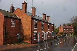
Charcoal and water-powered forges were a major feature in the area, the water used to turn sharpening wheels for scythe-making.[2] There was once a water-mill here: there is still a mill-pond,[2] a mill building (which now houses local businesses) and 19th century terraced housing, all of which is evidence of the former industry.
Notes[]
- ^ https://www.achurchnearyou.com/church/18768/
- ^ a b Local Walks: Chaddesley Corbett, Worcester News, retrieved 6 August 2013
| Wikimedia Commons has media related to Drayton, Worcestershire. |
This Worcestershire location article is a stub. You can help Wikipedia by . |
- Villages in Worcestershire
- Worcestershire geography stubs