Dubrovnik-Neretva County
Dubrovnik-Neretva County
Dubrovačko-neretvanska županija | |
|---|---|
         | |
 Flag  Coat of arms | |
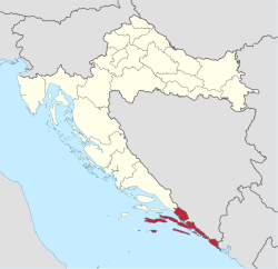 Dubrovnik-Neretva County within Croatia | |
| Country | Croatia |
| County seat | Dubrovnik |
| Government | |
| • Župan | (HDZ) |
| • Assembly | show
41 members |
| Area | |
| • Total | 1,781 km2 (688 sq mi) |
| Population (2011)[2] | |
| • Total | 122,568 |
| • Density | 69/km2 (180/sq mi) |
| Area code | 020 |
| ISO 3166 code | HR-19 |
| HDI (2019) | 0.859[3] very high · 4th |
| Website | edubrovnik.org |
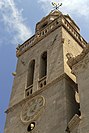
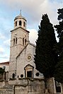
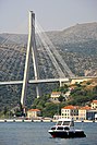
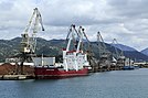
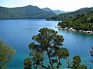
The Dubrovnik-Neretva County (pronounced [dǔbroːʋniːk-něreːtʋa]; Croatian: Dubrovačko-neretvanska županija, pronounced [dǔbroʋat͡ʃko-nerěːtʋanskaː ʒupǎnija]) is the southernmost county of Croatia, located in south Dalmatia. The county seat is Dubrovnik and other large towns are Korčula, Metković, Opuzen and Ploče. The Municipality of Neum, which belongs to neighbouring Bosnia and Herzegovina, divides the county in two parts which are connected only by the Pelješac Bridge. The southern part of the county consists of Dubrovnik and the surrounding area, including the Pelješac peninsula, and the islands of Korčula, Lastovo, Mljet, Šipan, Lopud and Koločep. The northern part of the county includes the Neretva Delta, the Baćina lakes north of Ploče, and a swath of hinterland near the southernmost slopes of Biokovo and around the hill of Rujnica. The northern part of the Mljet island is a national park. The Lastovo archipelago is a designated nature park. The southernmost tip of the county is the Prevlaka peninsula at the border with Montenegro. It is the only Croatian county that borders Montenegro.
Although the 9 kilometres-long stretch of coast belonging to Neum effectively makes the southern part of the county an exclave (disconnecting it from mainland Croatia) it is still connected with the rest of the country via territorial waters. Road traffic going to and from Dubrovnik through Neum is usually less subject to customs controls in order to reduce the traffic congestion. The road connecting Dubrovnik to the rest of the country via Neum has one lane per direction and bus lines passing through Neum often make rest stops there so that passengers can take advantage of lower Bosnian taxes and purchase tobacco and alcoholic beverages as they tend to be cheaper there.
Administrative division[]
On the local level, the Dubrovnik–Neretva county is further subdivided into 5 cities (grad, pl. gradovi) and 17 municipalities (općina, pl. općine):
- City of Dubrovnik (county seat)
- Town of Korčula
- Town of Metković
- Town of Opuzen
- Town of Ploče
- Municipality of Blato
- Municipality of Dubrovačko Primorje
- Municipality of Janjina
- Municipality of Konavle
- Municipality of Kula Norinska
- Municipality of Lastovo
- Municipality of Lumbarda
- Municipality of Mljet
- Municipality of Orebić
- Municipality of Pojezerje
- Municipality of Slivno
- Municipality of Smokvica
- Municipality of Ston
- Municipality of Trpanj
- Municipality of Vela Luka
- Municipality of Zažablje
- Municipality of Župa Dubrovačka
Demographics[]

|
| ||||||||||||||||||||||||||||||||||||||||||||||||||||||
| Source: Naselja i stanovništvo Republike Hrvatske 1857–2001, Croatian Bureau of Statistics, Zagreb, 2005 | |||||||||||||||||||||||||||||||||||||||||||||||||||||||
As of the 2011 census, the county had 122,568 residents. The population density is 69 people per km2.
Ethnic Croats form the majority with 94.4% of the population, followed by Serbs at 1.7%.[4]
Protected areas[]
- Mljet National Park
- Lastovo archipelago nature park
References[]
- ^ Ostroški, Ljiljana, ed. (December 2015). Statistički ljetopis Republike Hrvatske 2015 [Statistical Yearbook of the Republic of Croatia 2015] (PDF). Statistical Yearbook of the Republic of Croatia (in Croatian and English). 47. Zagreb: Croatian Bureau of Statistics. p. 62. ISSN 1333-3305. Retrieved 27 December 2015.
- ^ "Population by Age and Sex, by Settlements, 2011 Census: County of Dubrovnik-Neretva". Census of Population, Households and Dwellings 2011. Zagreb: Croatian Bureau of Statistics. December 2012.
- ^ "Sub-national HDI - Area Database - Global Data Lab". hdi.globaldatalab.org. Retrieved 2021-07-19.
- ^ "Population by Ethnicity, by Towns/Municipalities, 2011 Census: County of Dubrovnik-Neretva". Census of Population, Households and Dwellings 2011. Zagreb: Croatian Bureau of Statistics. December 2012.
External links[]
| Wikimedia Commons has media related to Dubrovnik-Neretva County. |
- Official website
 (in Croatian)
| show Subdivisions of Dubrovnik-Neretva County |
|---|

| Authority control |
|
|---|
Coordinates: 42°39′13″N 18°05′41″E / 42.65361°N 18.09472°E

- Dubrovnik-Neretva County
- Enclaves and exclaves
- Counties of Croatia